
Introduction:
What? : This is one of
the park more popular hikes, 2.5 miles long out and back will take you through
a meadows, canyon cliff viewing point, and waterfalls. The lower section of this
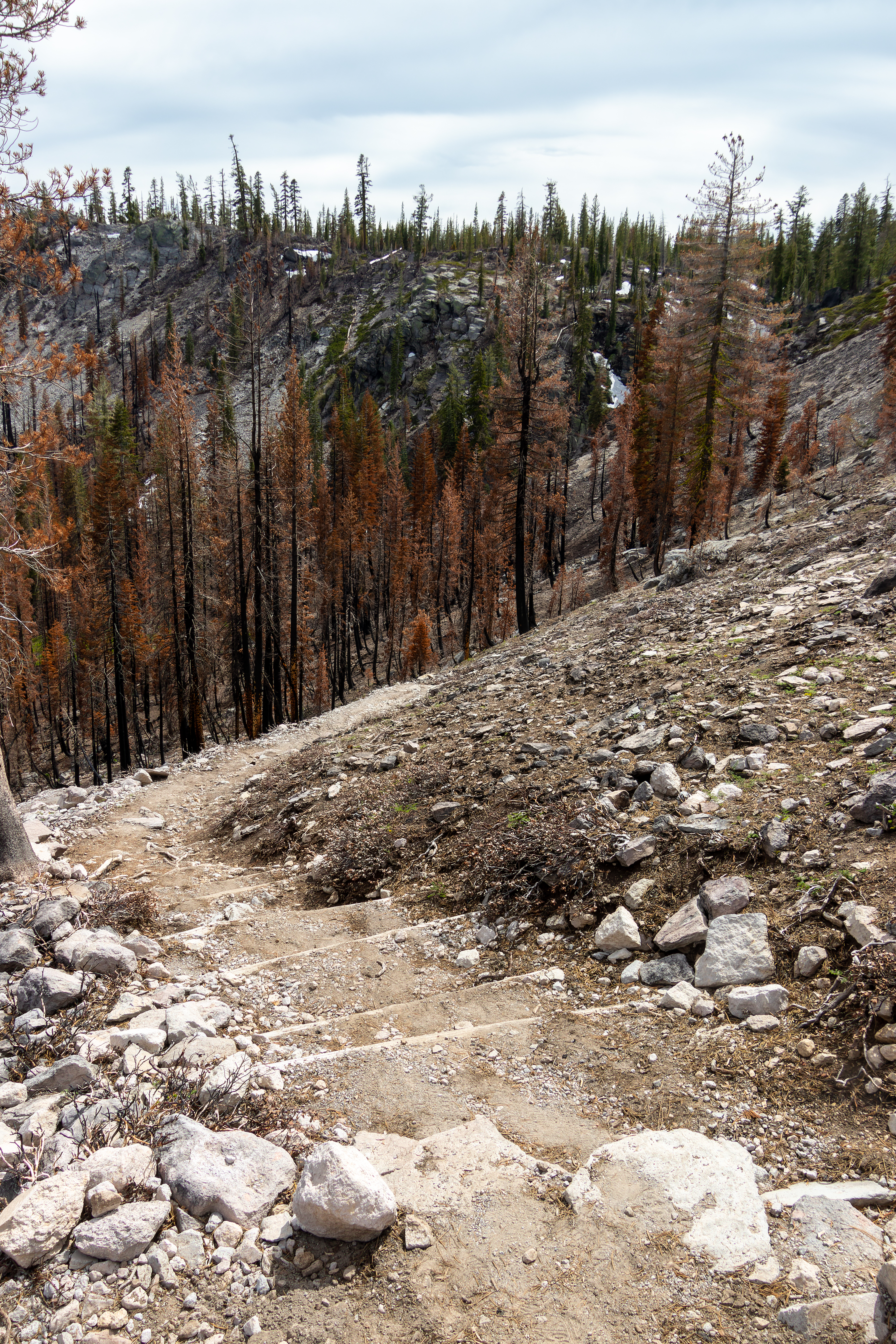
hike to the waterfall was damage by Dixie fire.
If you want to
hike longer you can combine this into a 4.6 miles loop trail that pass through
a lake and few landscapes viewing points.
This loop trail
section was also damaged by the Dixie fire, but when I hiked here in June 2022 the
trail was already cleared up by the park trail maintenance crew.


For a Beautiful Nature Prints - Visit my Etsy Store
Where? : The Kings
Creek trailhead is located on the main park road, 13 miles from Kohm
Yah-mah-nee Visitor Center (south park entrance) and 14 miles from Loomis
Ranger Station (north park entrance).
The roadside
parking is on the wide road pull-outs at both side of the park main road.
Google Map Link
When? : Summer and
early fall. At winter the road and the trail are covered with deep snow.
Additional Lassen Volcanic Park Blogs and Related Posts:
Lassen Volcanic NP – Trip Planning
Lassen Volcanic NP – Echo Lake and Cluster Lakes loop hikes
Lassen Volcanic NP – Kings Creek Waterfall Hike
Lassen Volcanic NP – Sulphur Works and Ridge Lakes Hike
Lassen Volcanic NP – Cinder Cone and Painted Dunes
North California - Waterfalls Loop Road-Trip (Redding – Shasta)
McArthur Burney Falls State Park
Potem Creek Falls, Shasta-Trinity National Forest
Hatchet Creek Falls, Shasta County
McCloud River Falls, Shasta-Trinity National Forest
Lake Siskiyou and Faery falls, Shasta County
Heart and Castle Lakes Hike, Shasta County
Hedge Creek Falls, Shasta County
Castle Crags State Park
Due note 1: This is one of
the most popular trails in the park, so arrive early if you want to avoid
crowds. Parking spots are available along both sides of the road by the
trailhead.
Due note 2: There are no
restrooms at the trailhead.
Due note 3: When I visit
here, June 2022, sections of the trails were hit by the Dixie fire and the
small viewing platform above the waterfall was destroyed and was closed for access.
You can still see the waterfall if you will walk to the cliff section just behind
the close viewing platform.
Due note 4: Pets are not
allowed on any hiking trails in Lassen Volcanic National Park.
Due note 5: Due to its
elevation and wind protected from the ridge above the Kings Creek Falls trail
can be covered in 15 feet or more of snow in the winter so check for trail
opening if you are coming early summer.
Due note 6: As Always bring
plenty of water to your hike, it can be hot out here and when crossing burned
forest areas there is no shade, and you are fully expose to sun.
Due note 7: Lassen is home
to an estimated 50 black bears. As in the rest of California there are only
Black Bears even if their color is brown. I saw that Kink Creek is a place you
may spot bears.
When hiking Cluster
Lakes loop hike, I saw a Bear, he was relatively far and running away from me,
but I still manage to take some pictures.
When Hiking be Bear
aware and stay safe, for more information:
https://www.nps.gov/lavo/planyourvisit/bear_safety.htm#storage

My thoughts: This is a
popular trail, I hiked here late in the afternoon but there were still 15 cars
at the roadside trail head.
Near the road
the trail was covered with melting snow packs but as I head down it cleared up completely.
Hiking to the
waterfall is all the way downhill so hiking back up to the road can be challenging,
just walk it slow and it will be over.
I must admit
that reaching to the waterfall was a little bit disappointing, it is not the
most impressive waterfall I saw, even at early summer where the river flowing
with melting snow water, probably late summer and fall it has less water and even
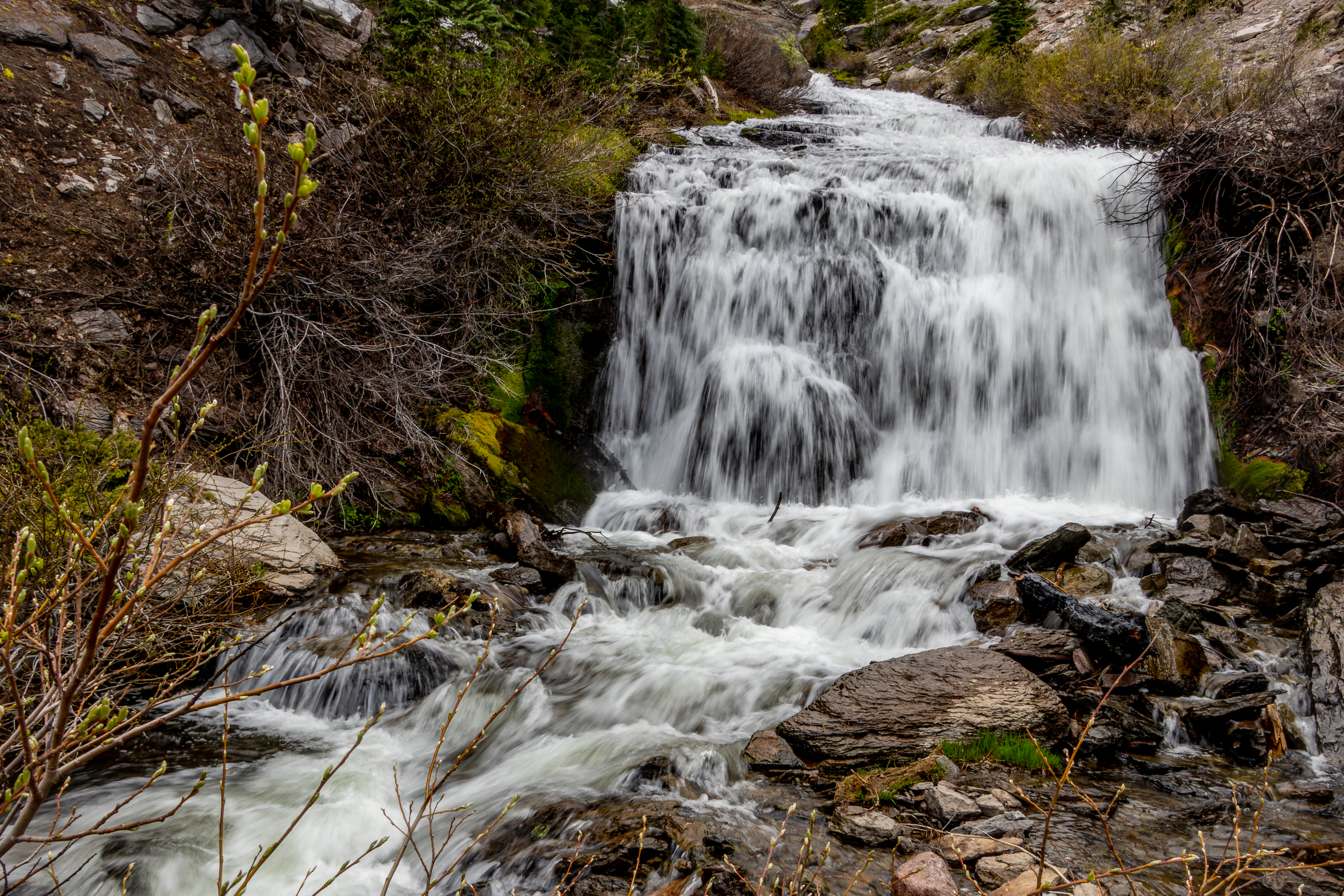
less impressive. I did like the view of the hundred feet long cascade section
of the gorge that is located before the waterfall (one way trail).


The visit:
Most people are
here for the 2.5 miles round trip to the waterfalls, this hike include 500 feet
elevation climbing on your way back so plan accordingly.
I will describe
below both the short out and back 2.5 miles waterfall hike and the 4.6 miles Bench
Lake Loop Trail.

Kings Creek Waterfall Hike:
The trail
descends from the road into a flat land at the edge of Lower Meadow, after 0.5
mile from the road you will reach a trail junction on your right, from here you
will come back if you decide to take the Bench Lake loop.

The route stays
relatively level where it stays to the left and Kings Creek turn right and drops
200 feet over the next quarter of a mile via dozens of small falls and cascades.
On your way you
will pass a clearly marked “Do Not Enter” trail, this one-way trail is used
only by people coming back from the cascade below, keep hiking straight.
At this section
the forest clears up and you will hike right to cliff edge viewing point
looking over the gorge below you and to the far park east section.


The Left fork trail
makes a longer gradual descent down, it leads away from the creek, and with a series
of switchbacks the trail descends all the way to the gorge below. After 1.1 miles
from the trailhead, you will reach a trail junction.

Here you need
to turn left and hike additional 0.3 miles to the waterfall.
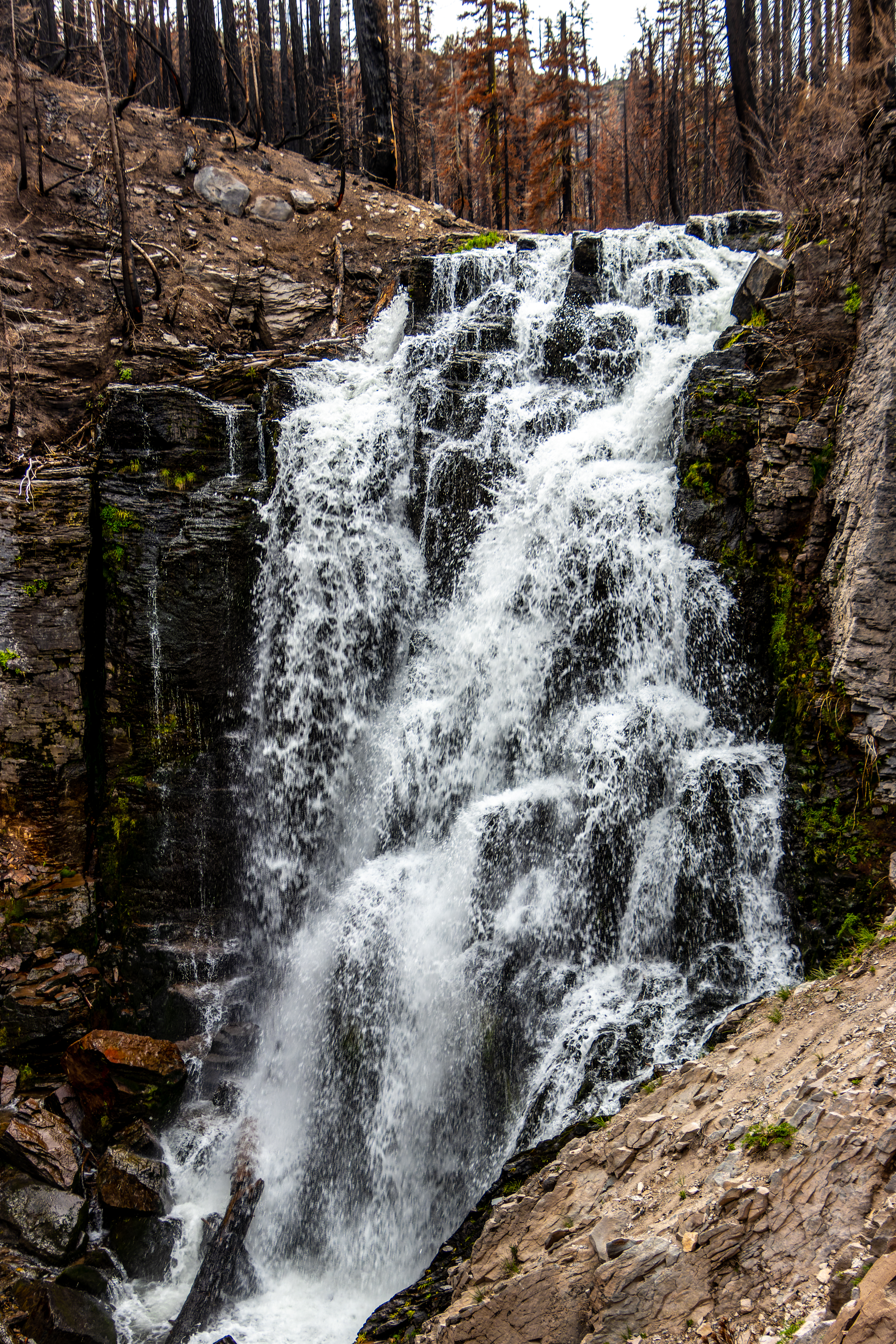
When I visit
here, during June 2022, the waterfall viewing platform was close to any access
because the fire destroyed the protecting fence.

I went behind
the viewing platform where you can have a view of the waterfall and hike down
to the base of it.

This 40-foot
waterfall is nice, but I must admit it was less impressive than I anticipated.
After visiting
the waterfall, and taking few pictures, you will hike back up to the parking
lot, this time walk into the creek and get into the one-way cascade section of
the trail.

Here the creek water
is running over long rockslide creating a narrow rushing cascade. The trail climbs
along the creek with series of steps and after short but steep climb you will
reach back the main trail.
Here you will turn
left and hike back to the starting point.

Bench Lake Loop Trail:
The entire loop
trail including visiting the cascade and the waterfall was 4.6 miles with 700
ft accent and it took me total of 2.5 hours to complete.
After visiting
the waterfall, I saw that I have time and decide to hike the Bench Lake loop.
Just before
reaching the waterfall there is a trail junction, here you will head into Bench
Lake Trail, you will cross the river to the other side.
From this creek
crossing the trail climbs alongside the lower section of expose rocky cliff. After
0.6 mile of hiking along the cliff line you will get into a small valley and
reach the small Bench Lake.
All the forest
section from Bench Lake to the meadows near our starting point was burned out; Here
you will witness firsthand how the fire change the landscape for many years to
come, the shallow small lake water was filled to black ash mud.


After the passing
the lake, the trail keeps heading east and descend for additional 0.35 mile,
there you will reach a trail junction. Here you need to turn right and start to
climb west.
After 0.3 mile
of climbing, you will see a trail to you left, Sifford Lakes Spur Trail that led
to few lakes, this looks like a fun hike to do but it was already getting late,
and I want to do another hike that day.
Keep hiking up
on Sifford Lakes Spur Trail for another 1.1 mile where it reaches back the
Kings Creek meadows.

I cross the meadows to the other side, reconnect to the main waterfall trail, turn left, and headed back to the trailhead.

Although not
long the loop is fun hike to do.
If this is a
must hike to do?
The answer is probably:
no, but this extend and diversify the waterfall hike.
I did this hike
clockwise, first visit the Waterfalls and only then went to the loop, I do
recommend doing it counterclockwise, start at the high section first, visit the
waterfall and from there take the one-way trail near the cascades on your way
up.
www:
https://www.nps.gov/thingstodo/hikekingscreekfalls.htm
Map:
https://www.nps.gov/carto/hfc/carto/media/LAVOmap1.pdf
Pictures:


Comments
Post a Comment