
Introduction:
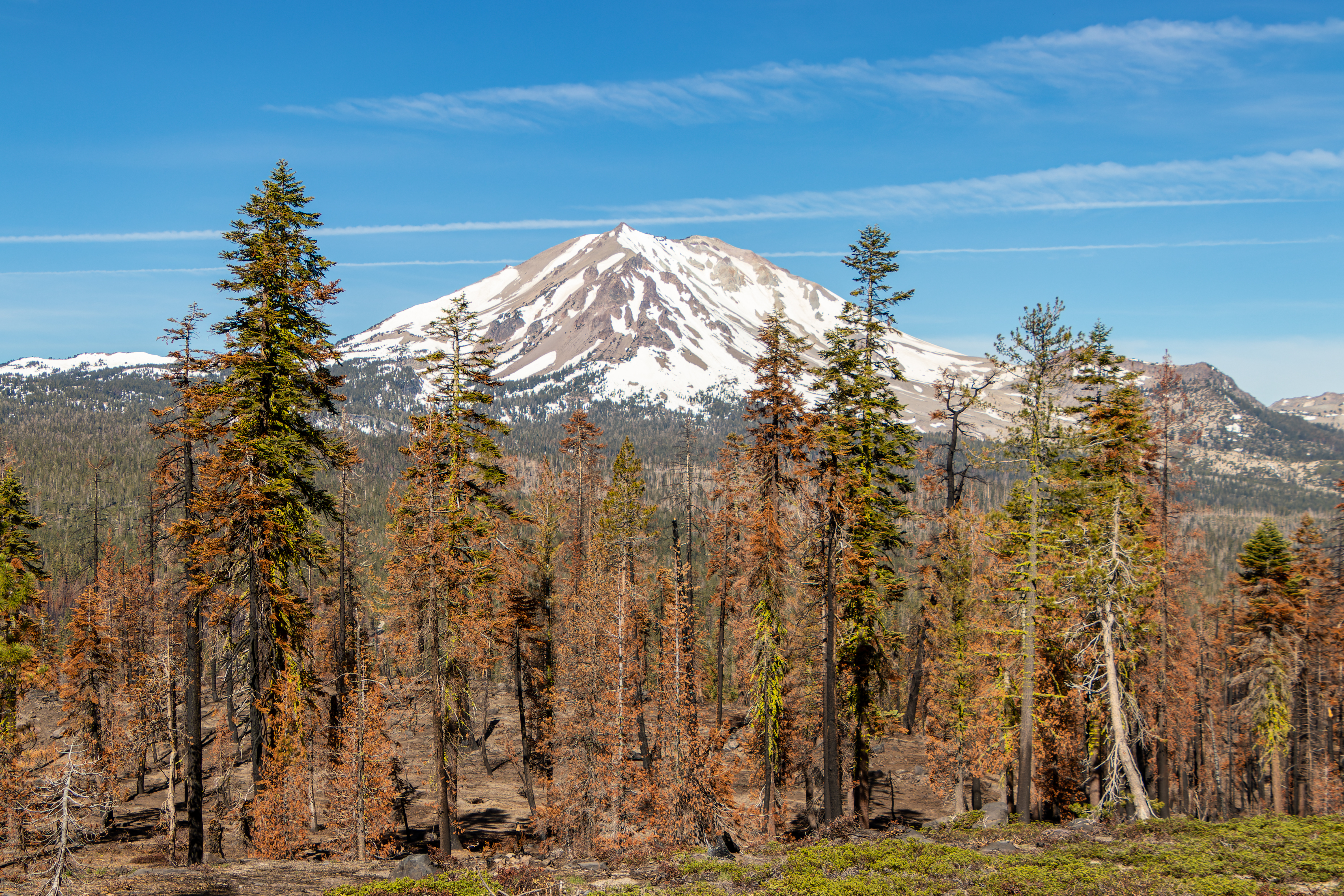
What? : Lassen
Volcanic National Park Located in northern California Sierra Mountains. It's
rich in hydrothermal sites, steaming fumaroles, forest, Alpine mountains, and clear
lakes. The summit of the 10,457-foot Lassen Peak Volcano dominates the
landscape and can be visible from many miles away.


Where? : Lassen
Volcanic National Park Located in northern California Sierra mountains, 50
miles east of the city of Redding. Highway 89 is the main park road that cross the
park western section from south to north, from highway 36 at the south to
highway 44 at the north. Other forest roads are leading to the east and north
sections of this large park.
Google Map Link

When? : The park
open year round but I highly recommend visiting here late summer and early
spring when all park locations are open and accessible. At winter and up to early
summer months (June and some years even July) the main park road can be still close,
and some hiking trails are not open to the public. The park lower sections can
be open at springtime so even if the park road is still not open to cross you
can still visit the north or south sections of the park.
At Winter, Kohm
Yah-mah-nee Visitor Center at the south park road is open but with almost no access
to internal park roads.


Additional Lassen Volcanic Park Blogs and Related Posts:
Lassen Volcanic NP – Trip Planning
Lassen Volcanic NP – Echo Lake and Cluster Lakes loop hikes
Lassen Volcanic NP – Kings Creek Waterfall Hike
Lassen Volcanic NP – Sulphur Works and Ridge Lakes Hike
Lassen Volcanic NP – Cinder Cone and Painted Dunes
North California - Waterfalls Loop Road-Trip (Redding – Shasta)
McArthur Burney Falls State Park
Potem Creek Falls, Shasta-Trinity National Forest
Hatchet Creek Falls, Shasta County
McCloud River Falls, Shasta-Trinity National Forest
Lake Siskiyou and Faery falls, Shasta County
Heart and Castle Lakes Hike, Shasta County
Hedge Creek Falls, Shasta County
Castle Crags State Park

Due note 1: Before
visiting the park check for road and trails opening, there is major change in
opening times between years, depending on the winter snow accumulation. When I
visit here at 2017, record snow year, they fully open the road crossing the
park only on August 1st and we had to change our visit plan, when
coming in 2022 it was open in June…
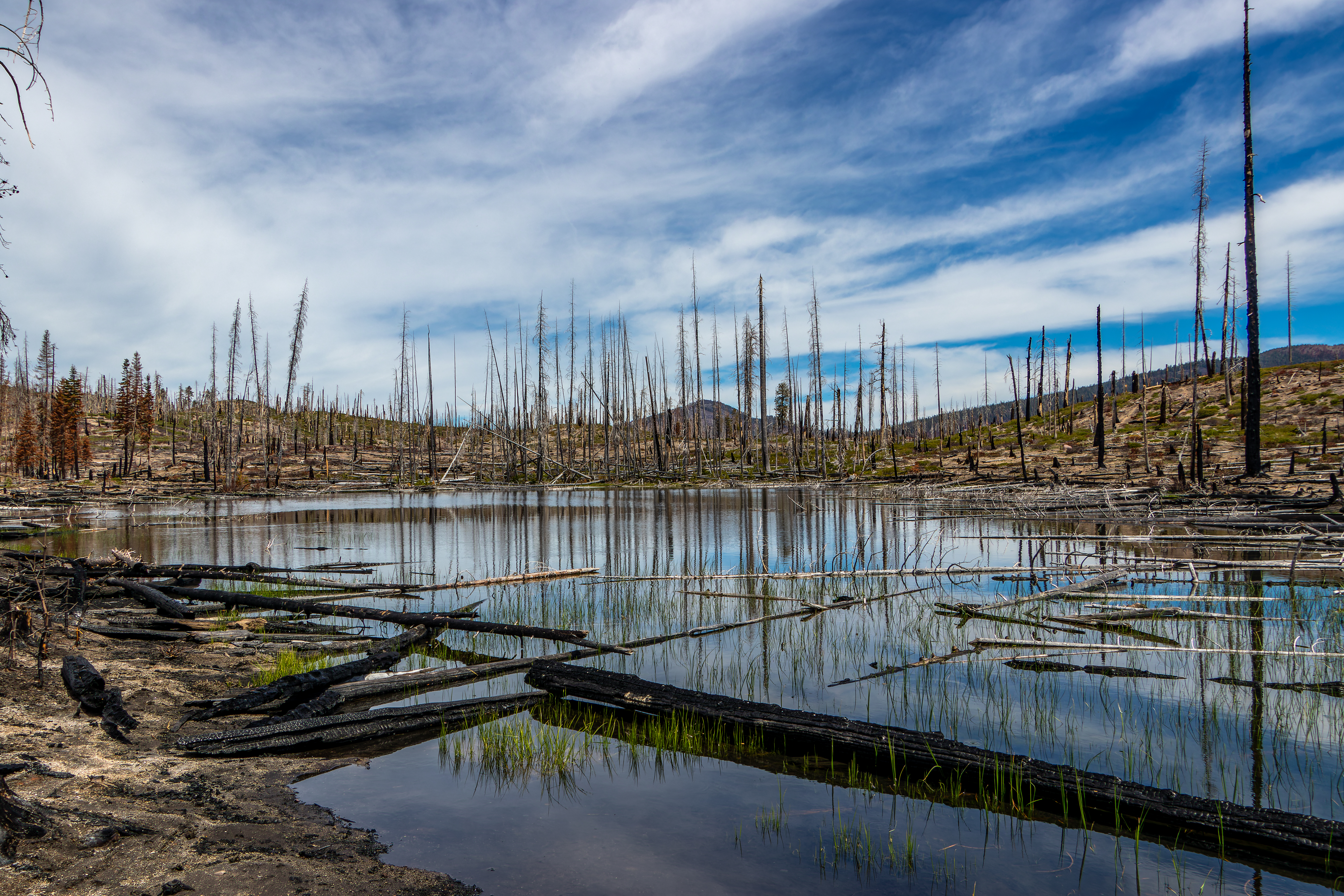
Due note 2: At the summer
of 2021 Dixie Fire impact over 60% of the park forest. There are many places with
dramatic, high intensity, burned impact where there are other areas where the
fire had only partial burned. Most of the east section of the park suffer from
this fire and the damage will be visible and significant for many years. Most
if not all the west park forest was not damaged by Dixie fire. The fire changed
the landscape for many years but the visit here is still rewording.
Due note 3: When I visit
here last time (June 2022) the Loomis Ranger Station and the museum at the
north park entrance was close. The nearby Manzanita Lake Camper Store was open,
and I was able to buy park map, some basic supply and ask informative questions.

Due note 4: The large and
new Kohm Yah-mah-nee Visitor Center at the south park entrance is open year-round.
First time I saw this in national park is that the visitor center parking lot
can be used for car or RV camping overnight (need to pay camping fees).
Due note 5: Pets are not
allowed on any hiking trails in Lassen Volcanic National Park. I saw that service
animals assisting a person with a disability are permitted on park trails,
check in the visitor center for exact limitations.
Due note 6: As Always bring
plenty of water to your hike, it can be hot out here and when crossing burned
forest areas there is no shade, and you are fully expose to sun.

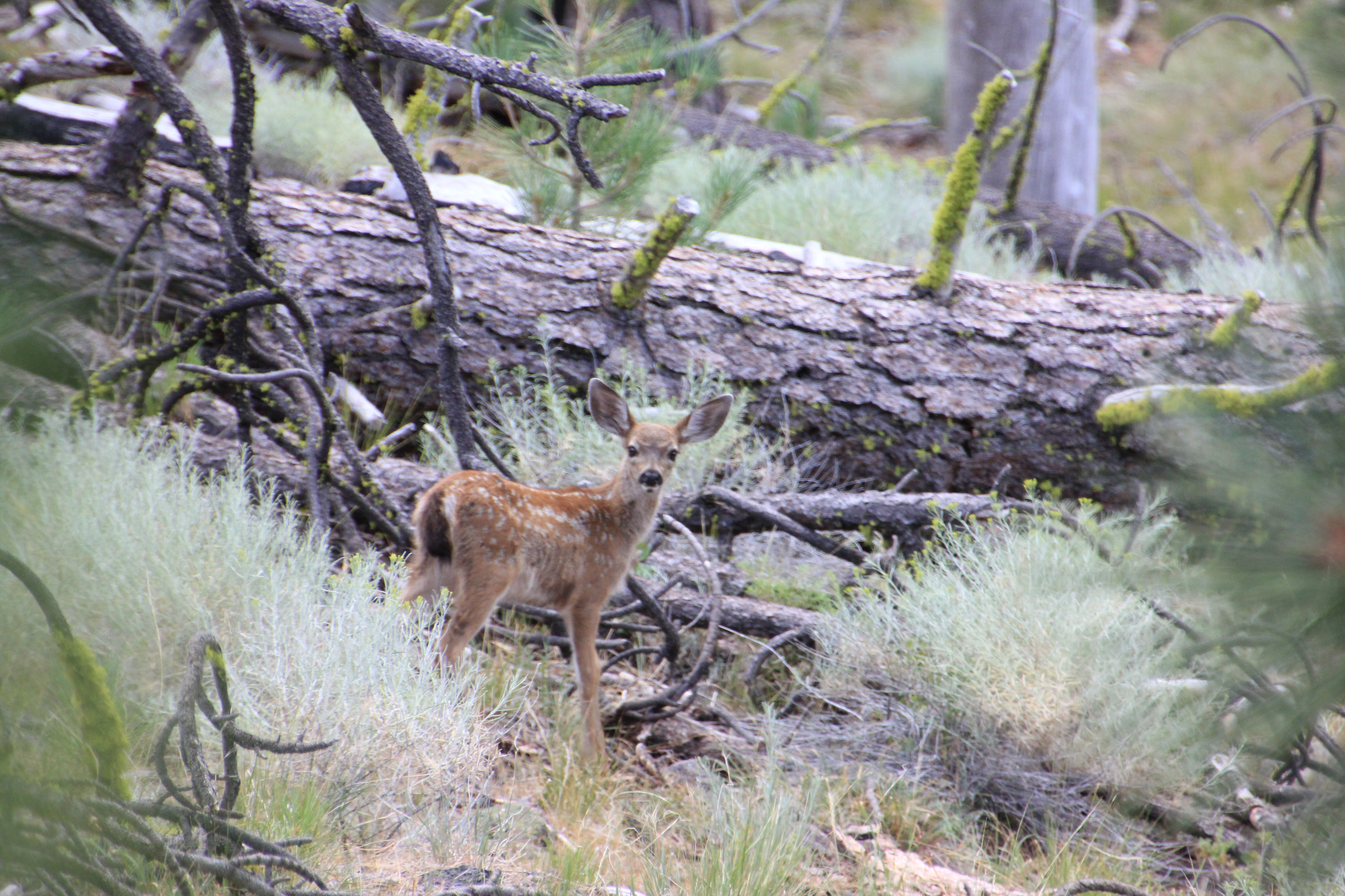
Due note 7: Lassen is home
to an estimated 50 black bears. As in the rest of California there are only
Black Bears even if their color is brown.
When hiking Cluster
Lakes loop hike, I saw a Bear, he was relatively far and running away from me,
but I still manage to take some pictures.
When Hiking be Bear
aware and stay safe, for more information:
https://www.nps.gov/lavo/planyourvisit/bear_safety.htm#storage


My thoughts: I visit this
park several times, last time was at summer 2022 after the 2021 Dixie fire that
impact most of the east side of the park. The large, burned forest area will be
impact for many years to come but you can still enjoy the long hikes into the
wilderness this park has to offer.
On top of the
“usual highlights suspects” you can expect from visiting Sierra Mountain Park
like lakes, forests, mountains peaks and alpine views at Lassen the hydrothermal
activities and the volcanic geology add another dimension and uniqueness to
this park visit.
My only “problem”
when visiting here is that because of the high amount of snow this park is
getting during winter months some park locations/trails can be open only late
in mid-summer, check trail and road opening conditions when you plan your
visit.

The visit:

Established in
1916, Lassen Volcanic National Park is home to 10,457-foot Lassen Peak that is
the largest plug dome volcano in the world and the southernmost volcano in the
Cascade Mountains Range.
Located in the
northeast corner of California, the park is home to all four types of volcanoes
(shield, composite, cinder cone, and plug dome) and you can still witness today
the bubbles, mud poots, steams, and other hydrothermal activity.
The park has
huge wilderness forest area with crystal lakes, meadows, and endless trail to
explore.
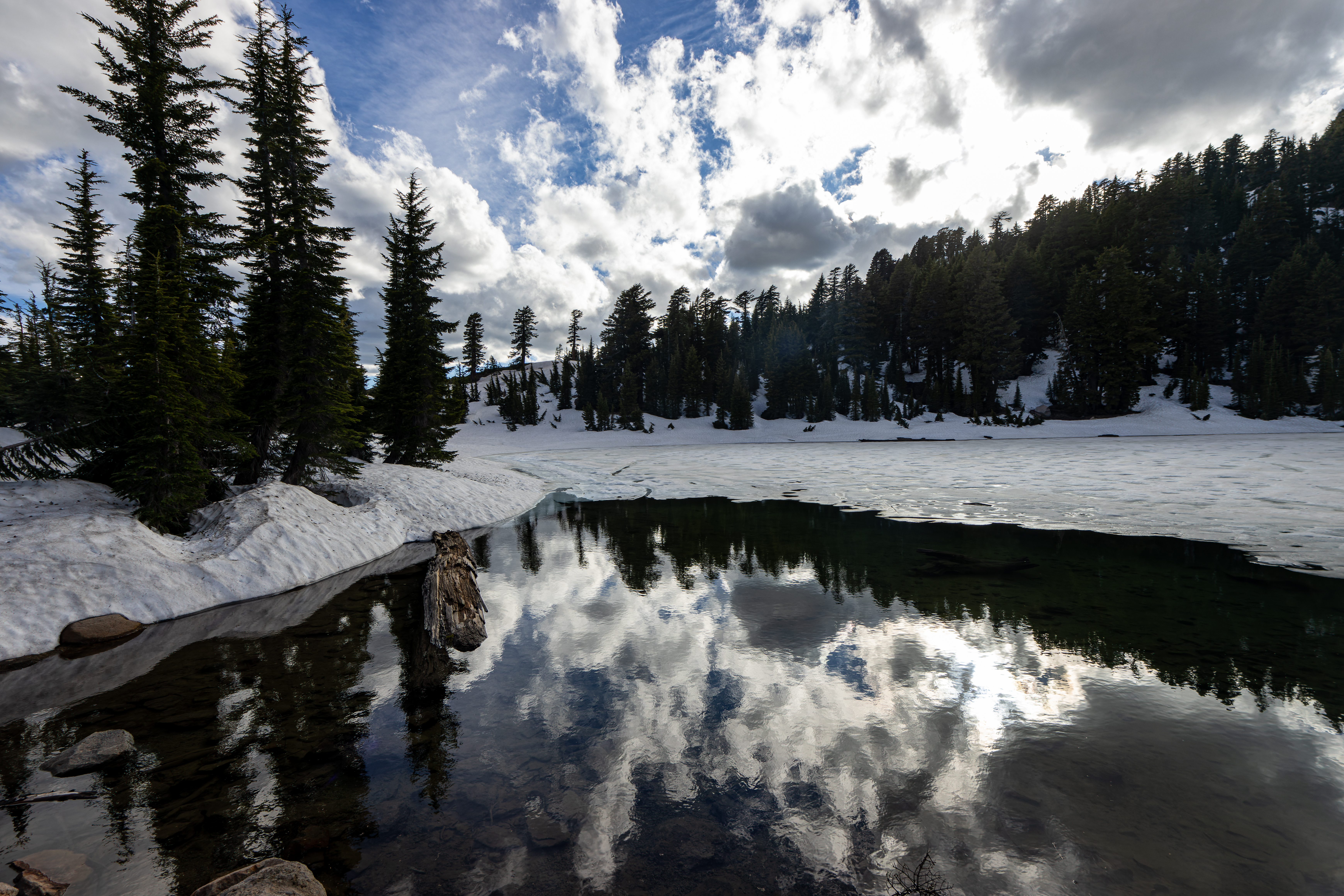
Visiting during winter and spring:
Due to the high
elevation mountain range and it location, the park has harsh and cold winters,
it gets more snowfall than anywhere else in the California Cascades and in specific
high elevation area snowbanks are persistent year-round.
While Lassen is
open year-round, many facilities, locations, roads, and trails are only open
for the relatively short summer and fall season. Road access is limited in the
winter months.
Check before
your visit at the park website on road conditions.

The 2021 Dixie fire:
At the summer
of 2021 Dixie Fire that was the largest ever recorded fire in California reached
its final size of 73,240 acres within the park boundaries, covering most of the
east south of the park area.
The west side
of the main park road there’s very little fire impact and everything looks green
but on the east side you can see the large burn forest devastation with dotted patches
of surviving trees.


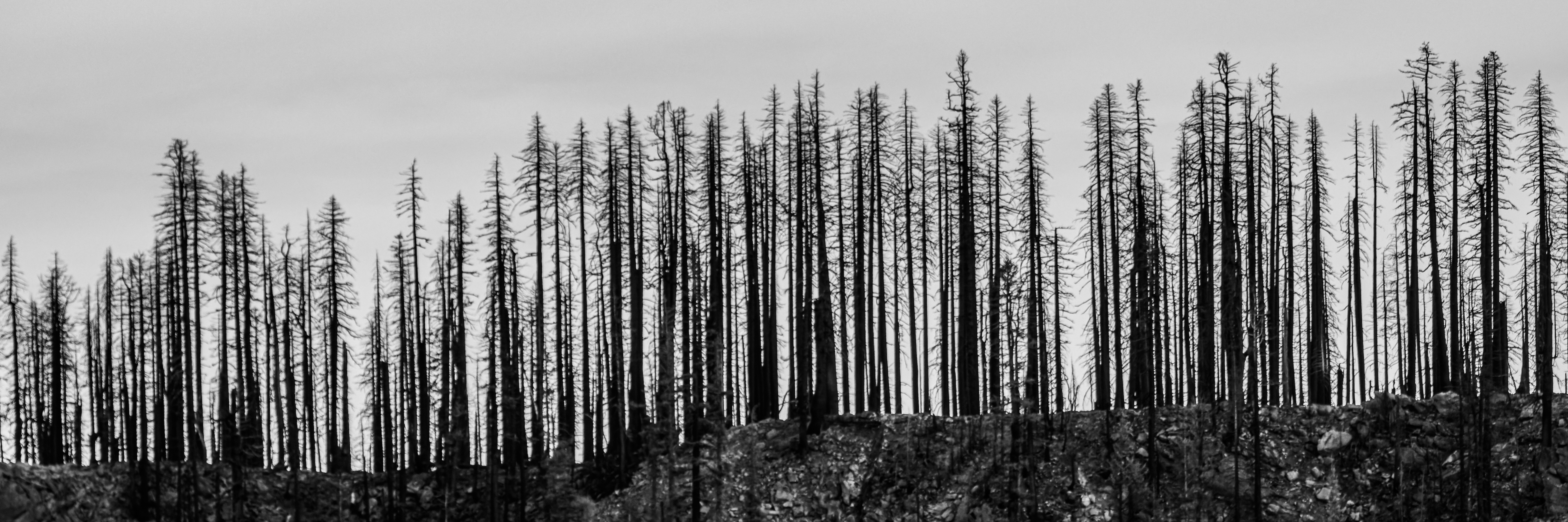
Over 60% of the
park forest has had fire in it. There are places with dramatic high intensity
burned impact where all you can see are black burned naked ded standing trunks where
there are other areas where the fire had only a light touch.
The Dixie Fire hit
all the northeast section of California and reached its final size of 963,309
acres making it the largest single fire in California history. You can see the huge,
burned forests areas when traveling to this region, once it was covered with
endless dense forest and today covered with standing black, burned, tree stamps.


1 day visit planning in the park:
If you are
planning one day visit at the park, I will recommend focusing your visit along the
30-mile park main highway.
You can drive
this road north to south or south to north, this depends mainly on where you
are coming from and what is your destination after the visit.
If this is a one-day
road-trip from the city of Redding than I will recommend starting from the north
entrance and drive south on the park main road.

The park scenic
route passes through dense forest with several alpine lakes and meadow, climb
up to 8,512 feet near Lassen Peak Trailhead, and from there descends the steep mountain
slopes into the southwest hydrothermal area.
Along the road
there are many designated viewpoints turnouts and parking areas near the
trailheads and the main road attractions.
For a day trip
you should probably plan to have at least one hike (2-5 miles long), the most
recommended one is Bumpass Hell (3 miles long) that demonstrate the best the
volcanic and thermal activity in the park. Unfortunately, it was still close
when I visit the park so I can’t provide personal information on this hike.
Another popular hiking option is Kings Creek Waterfall Hike (2 miles long).
An easy and
relax hiking option (1 miles long) that will rewords you with the “classical” Lassen
Peak reflection view can be done at Manzanita and Reflection Lakes near the
park north entrance.

Below I tried to provide high level information about different attraction points in the park.
Attraction and location points
along the main park road (listed from north to south):
Manzanita and Reflection Lake
One of the popular
easy hikes in the park is to walk around Manzanita Lake on an easy flat 1.5-mile
loop trail. From the west side of the lake, you can see the 10,457-foot Lassen
Peak reflected in the lake water (when there is no wind). A preferred time to visit
here is at late afternoon when the low sun lighting the peak slopes from the
west.
You can connect
this trail to another trail on the north side of the road. This addition of 1.2-mile-long
loop trail that circling Reflection Lake and the nearby Lily Pond. The entrance
to this trail is just across the road from ranger station parking lot.


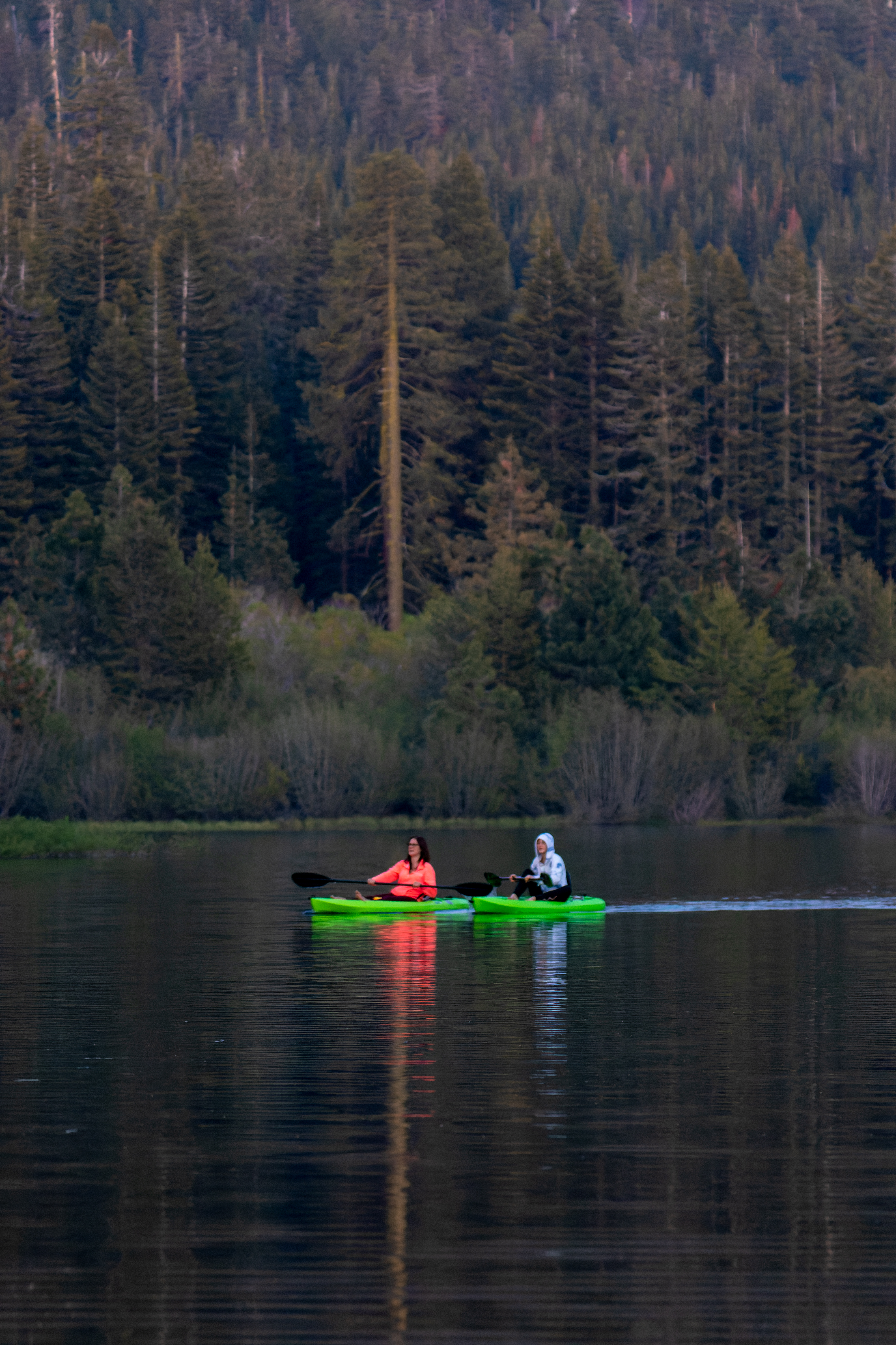
Loomis Ranger Station
Along the Manzanita
Lake you can find the large campground, cabins, Camper Store that also rent paddleboard
or kayak.
When I visit
there (June 2022) the ranger station and museum were close.

Paradise Meadow Hike:
Starting at
Paradise Meadow Trailhead this 2.8-miles hike out and back climb moderately for
1.3-mile 560 ft to the large Paradise Meadows that is surrounded by the
mountain range on it far side, on your way up you can see few waterfalls in the
creek below you.
This hike is
not a “must”, but it is not long and fun to do if you have one and a half hours
to spend here.


Summit Lake and Echo Lake Loop
Hike
Summit lake is
one of the park popular lakes with 2 campground sites (South and North), here
you can walk around the lake shore (0.8-mile-long hike), from the east lake
side you can see the reflection view of the park mountain peaks.
From Summit
Lake Ranger Station and Parking Lot (when driving south on highway 39 this is
just before Summit Lake North Campground) you can hike to Echo Lake, this is
4.3 miles long out and back hike. The hike to Echo Lake crosses a burned forest
section, other areas near Echo Lake were less affected from the fire.
From Summit
Lake Ranger Station I hiked a much longer loop hike of 12 miles long, this hike
went deep into the park wilderness and passes near many lakes, most of the
trail pass through burned forest areas.
I wrote a
detailed blog about this hike.


Kings Creek Waterfall Loop Hike
One of the most
popular short hikes in Lassen Volcanic National Park is the 1.5-mile route to
Kings Creek Falls (out and back with 500 ft elevation gain climbing back to the
car).
Here you can
see the 50 feet waterfall and the whitewater cascade running over the volcanic
rocks. Most people do this hike as out and back trail. The trail starts at the
main park road, going down into a large meadow and from there downhill the
whole way to the waterfall, so it is easy hike on the way down, but remember,
it is uphill the entire way back. On your way up you will take the one-way
trail section that climb parallel to the creek cascade section.
I did here a
longer loop hike (4.7 miles) starting at the same trail that is leading down to
the waterfall but from there I kept going to Bench Lake and came back to the
upper meadow area near the road.
See my detailed
blog about this hike.


Lassen Peak Trail
Lassen Peak
Trail climbs to the summit of the largest plug dome volcanoes in the world. The
trail is out and back 5 miles long that beginning at the Lassen Peak parking
area (8500 ft), the trail climbs additional 1950 ft to the summit top.
Snow Conditions
can persist through the summer months, when I visit here in June 2022 the trail
was still partly covered with snow. Wear proper footwear spikes and consider
using trekking poles to help maintain balance.
Unfortunately, At
my last visit I did not have the time to hike this trail so I can’t provide
more information about this hike, looks like I need to visit here again 😊


Bumpass Hell
Named for the
unfortunate Kendall Bumpass who burned his leg when he broke through a thin
layer of crust and fell into scalding water.
This gentle
3-mile round-trip hike includes a stretch along a boardwalk with close-up views
of boiling mud pots. This is one of the park most visited attraction points, so
I do recommend coming here early in the morning or late at the afternoon when
it is less crowded.
Bumpass Hell large
parking area is located 7 miles from the Southwest Park entrance (if you are
coming from the north this is after Lake Helen). The trail starts with gradual
climb on it first mile then 200-foot descent into the hydrothermal basin.
Stay on
established trails and boardwalks in/around the basin. Ground in hydrothermal
areas can look solid but may be a thin crust hiding pools of acidic boiling
water or mud. Water and mud in hydrothermal areas is acidic.
Because of its
location and high elevation this trail gets a lot of snow during winter and
usually open late in the season, check for trail conditions at the park
website.
When I visit
the park in June 2022 the trail was still covered with snow and close to any
public access so I can’t provide more information about it.


Sulphur Works and hike to Ridge
Lakes
Located on the park
main road you can stop at Sulphur Works Parking, 1.1 mile from Kohm Yah-mah-nee
Visitor Center. Here you can see, and smell, the bubbling sulfur hydrothermal
area on both sides of the road.
I wrote a
detailed blog on this park attraction and the hike I did from here to the
nearby Ridge Lakes.
See my detailed
blog about this hike.


Kohm Yah-mah-nee Visitor Center
This year-round
visitor center is located one mile from the Southwest Entrance. The visitor
center offers an information desk, exhibit hall, auditorium, amphitheater, park
store, dining area with fireplace, patio, and a gift shop and cafe. Free Wi-Fi
is available inside.
This is the
first time I saw in National Park that visitor center parking is allowing car
camping for the night. Camping in self-contained vehicles (i.e., no tents) is open
and permitted in the adjacent parking area year-round with a camping fee.


Other Park attractions that are
not on the main park road:
Cinder Cone and Painted Dunes:
Located in the
north Butte Lake Area of the park the dramatic Cinder Cone volcano display a
perfect cone shape volcano. At the end of your out and back 4 miles hike, you
will climb the steep 200-foot ascent to the summit. From the top rim trail, you
will enjoy views of the dramatic cinder cone and the colorful Painted Dunes
below you.
See my detailed
blog about this hike.


Warner Valley and Juniper Lake
Sections:
Juniper Lake is
a large lake located at the southeast corner of Lassen Volcanic National Park.
This area was severely damaged by Dixie fire. I never visit here so I can’t provide
information what you can do in this area.
www:
https://www.nps.gov/lavo/index.htm
Map:
https://www.nps.gov/carto/hfc/carto/media/LAVOmap1.pdf
Pictures:


Comments
Post a Comment