
Introduction:
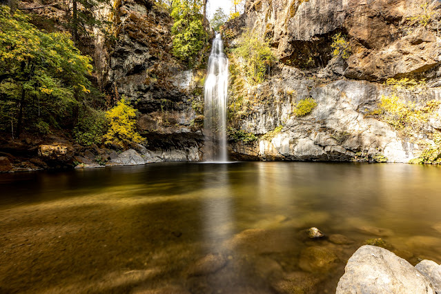
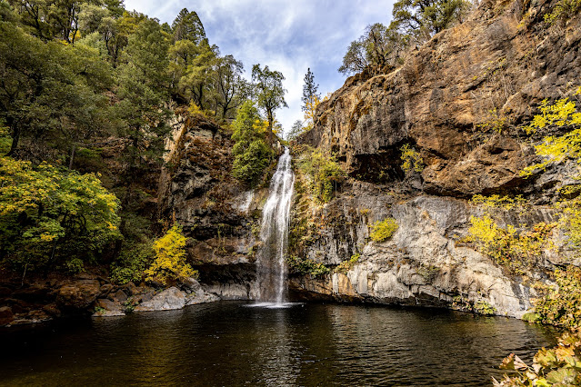
What? : The 70-foot-tall
Potem Creek Falls drop is impressive, and it has a large swimming pool at it
base.
This location is part of my "North California Waterfall Loop" road-trip suggestion.
Where? : Potem Falls is
located east of Redding. From highway 5 drive east on highway 299 for 30.5
miles and then turn left onto Fenders Ferry Road. Additional 9.5 miles drive on
dirt road will bring you to the 0.25-mile hike trailhead.
Google Map Link

When? : Year round, preferred
during summertime.
Due note 1: This area is part
USDA Forest Service, Shasta Lake Ranger Station, no fees needed.
Due note 2: Fenders Ferry
Road is a well-maintained dirt road; this forest road is in good condition and four-wheel
drive, or high clearance vehicle are not mandatory. Allow yourself at list 1/2
hour to reach from highway 299 to the falls trailhead.
Due note 3: This visit can
be combined with other nearby waterfalls visits, including: Hatchet Creek Falls
and McArthur Burney Falls State Park (one of the most beautiful waterfall in
California)
Due note 4: Overall,
including the driving the forest road from highway 299 and the waterfall short
hike this can be 1.5-2 hours visit.
My thoughts: Potem Creek
Falls is one of those hidden places with an amazing waterfall that most people
never heard off. I think that the Potem Creek Falls is something that should be
on your “Pleases to Visit” list.

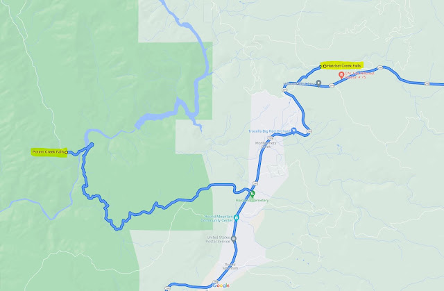
Detailed driving instructions:
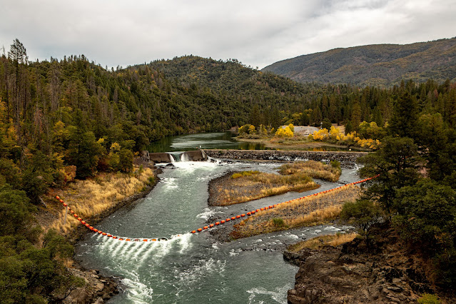
From Redding take highway 299 East Turn a left on Fenders Ferry Rd. (30.5 miles east of highway 5). The paved road turns into a dirt road after 3.5 miles. Keep driving the forest road, after 5.5 miles you will cross the Pit River on the impressive Fenders Ferry bridge, here you’ll see the PG&E dam on the right.


Soon after crossing
the bridge the dirt road start to climb to the right and you will soon see the trailhead
to the falls to your left, park your car on the sideroad.
Watch carefully
for the unsigned trailhead on the left, 0.6 mile beyond the bridge.
Total distance
from 299 E to the falls is 9.4 miles.

Addition North California blog posts:- North California - Waterfalls Loop Road-Trip (Redding – Shasta)
- McArthur Burney Falls State Park
- Hatchet Creek Falls, Shasta County
- McCloud River Falls, Shasta-Trinity National Forest
- Lake Siskiyou and Faery falls, Shasta County
- Heart and Castle Lakes Hike, Shasta County
- Hedge Creek Falls, Shasta County
- Castle Crags State Park
- Redwood Parks at Northern California Coastline – Visit Planning
- Highway 101 Attractions between Leggett to Avenue of the Giants
The visit:
From the roadside
parking, Potem Falls Trail is a short down and up 0.4-mile hike, a series of
three switchbacks will take you all the way down to the creek below. The trail
ends at a small overlook, but you can make your way down another 15 or so feet
to the water.
The 70-foot-tall
waterfall drop is impressive, and it has a large swimming pool.
After enjoying
the view and your swim you need to hike back up the short trail to your car.
Since 2021 has
been such a dry year and I came just before the winter (Oct.) the waterfall was
not so much overflowing but still it was impressive to see.
Pictures:


Comments
Post a Comment