
Introduction:
What? :
This is the
most beautiful and unique section of Highway 1, for it 123 miles length you
will have a breathtaking ocean view with attractions worth stopping along the way.
Although it can
be done by a half a day drive you should plan for this road section a full day.
In this blog I will
describe mainly the north 50 miles section of the road as well as the south
section near Morro Bay.
Important Note:
Before you trip please check in advance highway 1 road conditions:
Big Sur section of the road can be block for traffic in sections as result of landslides. If the road is block there is no way to pass it and you must drive back to your entry point and use highway 101.
As Of May 2023 the road is close in both directions midway between Big Sur and San Simeon, and it is not clear yet when you can drive north <--> south on this road section.


Where? :
Located in the
central coastline of California, south of Monterey and north of Morro Bay.
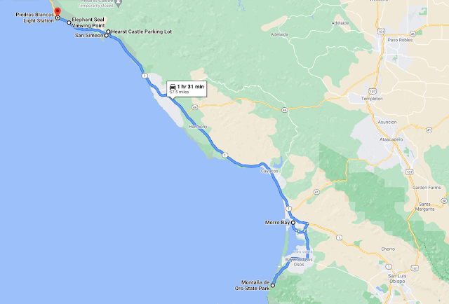
Google Map Link
Few Related Blog Links:
Weather:
You will experience
moderate weather all year long, with temperatures ranging from 57 – 65 degrees.
Fall: Sunny
mornings and warm afternoons.
Winter: Can be
windy with occasional shower.
Spring: Provides
cool, sunny weather.
Summer: Mornings often deliver a foggy marine layer covering the coastline, this create cooling effect. This fog usually clears by the afternoon and the weather get
much warmer.


Due note 1: It is highly recommended to drive highway 1 from north to south, at that driving direction you are on the ocean side, has a better view from the car and can easily and safely find places to stop and enjoy the view.
Just to be clear, Everything can be done also when driving from south
to north. you need to be carful when crossing the incoming traffic.
Due note 2: Summer is the busiest time of the year on the Pacific Coast Highway, the same goes for weekends.
Plan accordingly, everything will take you longer than expected.
Due note 3: This is a one-lane road for all this highway1 segment, in many places it is narrow winding cliff road.
It is not allowed and too dangerous to pass slow moving cars or RVs in many sections.
Expect a slow driving with many short stops at roadside viewing points along the way.
If you are driving slowly, try to find roadside turnouts
and clear the way.

Due note 4: Only few gas stations
are available in this long road section, make sure you have a full tank of gas
before setting out south from Carmel-by-the-Sea or driving north from Morro Bay.
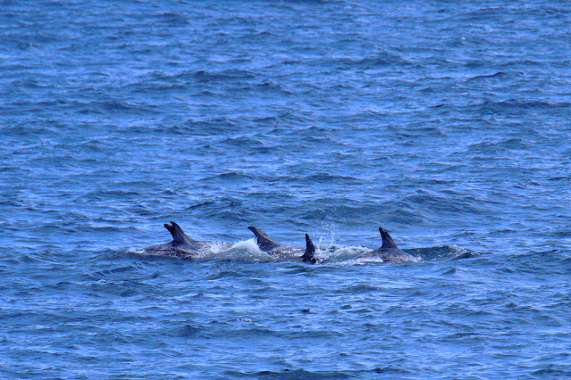
Due note 5: If
you are lucky, you may spot in the ocean migrating gray whales, from December
to May.
My thoughts:
No wonder why
this road section is considered to be one of the must-drive cynic highways in
America. A lot to see from the road and many places to visit along the way.
I drove this road many times, so I manage to visit many of the parks and locations along this road but for someone that doing this for the first time for 1 or 2 days plan in advance what you where you want to stop, do and see.
The visit:
I did section
of this road several times and never got bored, every time I discovered new
things.


The driving planning:
You’re planning
and activities depends on how much time you planned for this road, where and how
early you start your day, where you plan to finish it for the night and what
you want to do or see.
As always,
remember that you cannot see and do it all in one visit.
The section from Monterey to Morro Bay:
This road section
may seem to take 3 hours, after-all it is only 123 miles long, but it will take
you at list half a day to drive it with only few viewing points stops along the
way.
This section of
the road can be done in half a day (5-6 hr), but I recommend to plan for a full
day drive from Monterey to Morro Bay.
Plan to stop
for short picture-taking opportunities along the road at the countless amazing pointes
along the way and also to visit one park.

If driving it from the north you can sleep at Morro Bay, at San Luis Obispo (15 min drive inland from Morro bay) or at the tourist attraction coastal town of Pismo Beach.
Additional 2 hours’ drive south will take all the way to Santa Barbara.
Attractions along the way:
Below I listed the recommended to visit places along the road from north to south (the recommended direction to drive, see due note 1).
I wrote a short description, for some location
I wrote a full blog (follow the link).
My list of must see attraction
along the road:
- Bixby Creek
Bridge (20 min stop)
- Big Sur
Station/Park (30 min stop)
- Julia
Pfeiffer Burns State Park - McWay Falls (30 min stop)
- Elephant Seal
Viewing Point (30 min stop)
- Countless amazing
viewing point along the road
Best nature parks along the road:
- Point Lobos
State Natural Reserve (2-3)
- Pfeiffer Big Sur State Park (1-3, depending on your hike)- Pfeiffer
Beach (1 hr)


Full list of attractions along the
road:
Carmel By the Sea:
A small tourist upscale town located just south of Monterey. The town has a nice center with many art galleries, shops, and restaurants.
A short distance walk down from the main street will lead you to the bay with long stretch of sandy beach.
When entering
the main town road, you will see on your left the Carmel Mission Basilica
Museum. If you stayed and visit Monterey not sure this is a must visit on your
highway 1 road trip.

Point Lobos State Natural Reserve:
A popular park with one of the best California coastal landscapes.
Large rocky cliffs, coves, and ragged ocean coastline as well as many marine animals and birds.
This park is very popular
and may be overcrowded during weekends, when parking are full visitors park
their cars on highway 1 sideways, drive slowly.


Garrapata State Park and Soberanes
Point:
I did not visit
here, short hiking option to Soberanes hill-top Point. You can also hike inland
up into the coast ridges.
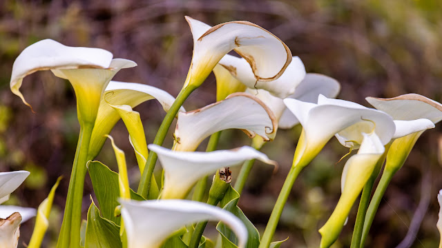
Garrapata Beach:
Sandy beach access below the ocean cliffs, on the south side of the beach you can access the Garrapata Creek with the arch road bridge. At springtime, the cliffs overlooking the ocean are covered with Calla lilies during the blooming season.
Not a must
visit, if you have time and want to explore the beach below this is a good
place to do so.
Notleys Landing viewpoint:
A good viewing
point to stop and see the ragged coastline to the south. There is also a restaurant
nearby (Carmel restaurant), a short stop on your way.


Rocky Creek Bridge:
A large arch
bridge crossing the canyon below, there are only few parking spots just before
the bridge.

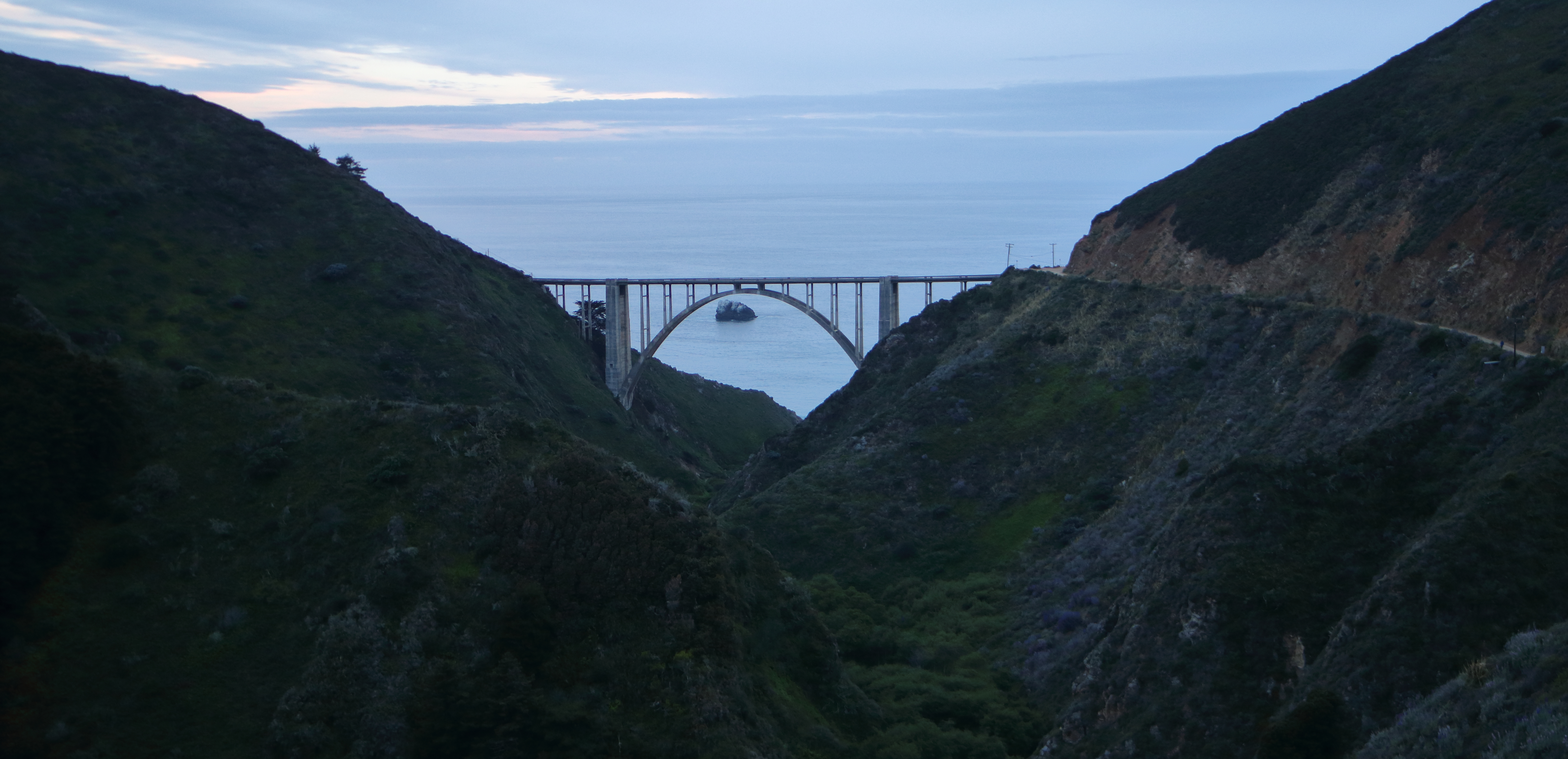
Bixby Creek Bridge:
Probably the most
famous bridge of this section of the road. It was completed in 1932 and hovers
260 feet above the steep canyon below. There is a small parking lot just before
the bridge and on the other side of the road.


Point Sur Lighthouse and Naval Facility Historic Park:
Large dominate bluff
with a lighthouse and research center, near the road you can find the old top-secret
submarine defense system Naval base.


Andrew Molera State Park:
This is a large
nature park with a sandy beach located a mile away from the road. the park is located
where the big sur river is flowing to the ocean. Not a must stop if this is
your first highway 1 exploration and you are short in time.


Located at the
gorge of the Big Sur river where the coastal redwoods forest flourish in the creek
along the Big Sur River.
This is an excellent
place to stop to eat something, there is a visitor center with useful local
information.
This location is the entry point for hikes into the Big Sur mountain ridge and wilderness. you can also do here few shorter hikes to a waterfall or to high viewing point.
Pfeiffer
Big Sur is an extremely popular campground, reservation is a must, even at winter.
https://www.parks.ca.gov/pages/570/files/PfeifferBigSurSPFinalWebLayout012016.pdf

Pfeiffer Beach:
A narrow road
will take you to the secluded small beach. It is famous for its purple sand and
for the few large rock formations in the ocean, at a specific winter day the
sunset light crosses a small tunnel in one of the rooks.


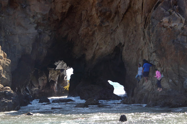

Partington Cove:
A small hidden
cove, a 1-mile round trip trail will take you down from the road level to the
ocean below. You need to park your car on the side of highway 1 and follow the
clear trail, at some point you will cross a small tunnel that will lead you to
the hidden cove.
This is a short,
less than 1 hr, stop and a hike on your road-trip, a good opportunity to starch
your leg and do some hiking.


Julia Pfeiffer Burns State Park -
McWay Falls
One of the most
beautiful waterfalls I ever saw, a highly recommended stop, if you do not have
time it can be very short, just to see the waterfall from the roadside.
The small river
is flowing from the large rocky cliffs directly into the ocean bay below. If you
are coming from north the best is to stop just before the park entrance and
enjoy the view from above, you can also stop later in the park itself on the
left (east) side of the road. From the parking lot there is a short easy hiking
trail that cross underneath the road through a small tunnel to the viewpoint near
the bay, the waterfall is right on the other side cliffs.


Limekiln State Park:
I did not visit
here so I cannot recommend
Sand Dollar Beach:
I did not visit
here so I cannot recommend


Salmon Creek Falls:
I did not visit
here so I cannot recommend
Ragged Point - Scenic View:
I did not visit
here so I cannot recommend
Piedras Blancas Light Station:
Small light house
in the open land, no access to cars, if you want to hike you need to park your
car north of the lighthouse

Elephant Seal Viewing Point:
Probably the
best place to see up-close large herd of Elephant Seal. Park your car and from
the nearby deck you can enjoy the view few feats below you.


San Simeon Pier:
Nice sandy beach
with a large pier.


Hearst Castle:
This National
Historic Landmark is the castle of William Randolph Hearst, it was built
between 1919 and 1947. There are few options for organized tours in the castle.
I did not visit
here so I cannot recommend

Hearst San Simeon State Park:
I did not visit
here so I cannot recommend
Morro Bay:
A tourist small
town located at the protected Morro bay with the iconic huge rock in front of
it. Recommended place to spend the night.


Additional Pictures:


Beautiful pictures and wonderful short comments about it.I have traveled the amazing section of highway 1 from Monterey all the way to Santa Monica and it is amazingly beatuful!
ReplyDeleteThe article you've shared here is fantastic about things to do in Denver because it provides a wealth of information that will be incredibly beneficial to me. Thank you for sharing that. Continue to post.
ReplyDeleteI am full of stuck after see these all the images and at the time I have a plan to visit west coast bus tour, so I think this is the perfect choice to visit this city and see these all the beauty.
ReplyDelete