Introduction:
What? :
Page, Arizona
is one of the most tourist popular small-towns destination in northern Arizona.
The town was only
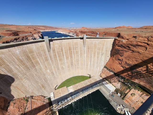
founded in 1957 as a housing site for workers building the Colorado River Glen
Canyon Dam and Bridge (finish construction in 1963), making it one of the youngest
communities in the United States.
Over the years
and with the increase in nature and outdoor tourist activity in the west of USA
the town has become a hub for people visiting this amazing area.
The town proximity
to some of the most amazing natural beauties in western USA increase it
attractivity that lead to flooding of the number of visitors coming here.
Some are tourists
on their southwest road-trip that are just passing through here when traveling between
Utah and Arizona, they might stay for one afternoon/night. Others are visitors
that make Page as their local “basecamp”, they invest few days staying here,
visiting many of the nearby attraction’s and doing variety of outdoor
activities.
Near the town
you can find Glen Canyon Dam, holding the Colorado River, creating behind it Lake
Powell. The lake was declared as Glen Canyon National Recreation Area offers many
lakes related recreational activities, from houseboating, water skin, jet sky,
kayaking, swimming in the local lake beaches, and even hiking in the lake
canyons.
The town is located
right near the land of the Navajo Nation, Indian reservation that govern a vast
section of northeast Arizona. Historically, the Page city land was purchased by
the government from the Navajo Nation reservation to build the dam and create
the town. There are many activities nearby that are on Navajo Nation, respect
the local regulation including the need for local guide for most of the trips,
including Antelope Canyon visits.
Just to mention
few famous locations near the town (many more are listed below):
·
Horseshoe Bend
·
Antelope Canyon
·
Lake Powel
·
North and South Rims of the Grand
Canyon National Park
·
Monument Valley
Where? :
The city is
located at northern central Arizona, right by the border with the state of Utah.
It will take
you 4-hours’ drive from Phoenix, 2 Hours’ Drive from Flagstaff, driving north
on highway 89 to get to Page.
Google Map Link
Distances and driving time from
Page to top tourist locations in South Utah, North Arizona:
Flagstaff,
Arizona 2.15 hours / 129 mi
Sedona, Arizona
3 hours / 158 mi
Glen Canyon
National Recreation Area - Multiple entry points 3 miles from town.
Grand Canyon
National Park South Rim - 2 hours / 119 mi
Marble Canyon,
Arizona 43 min / 39 mi
Grand Canyon
National Park North Rim - 2.5 hours / 123 mi
Kanab, Utah
1.25 hours / 74 mi
Zion National
Park 2.25 hours / 116 mi
Bryce Canyon
National Park 2.5 hours / 151 mi
Monument
Valley, Arizona 2 hours / 120 mi
Moab, Utah 4.5
hours / 273 mi
Arches National
Park 4.5 hours / 286 mi
Canyonland
National Park, Island In the Sky 5 hours / 305 mi
Page, AZ time zone:
All tour times
and confirmations are in ARIZONA TIME
Summertime:
Same time as Pacific Time.
Wintertime Same
time as Mountain Time.
No Daylight-Saving
Time – Not Utah Time – Not Navajo Nation Time.
Because the
Utah State Line is less than 7 miles away, cell phone towers from Utah (and the
surrounding Navajo Nation) often will be the wrong time!
Do yourself a
favor and check local time at your hotel night or ask locals.
Or you can also
manually set your cell phone to PHOENIX, AZ time.
When? :
Summer (May –
September) is peak tourism season in this area as in many other southwest
destinations and as many are coming to enjoy Lake Powell water activities. As a
result, at summer there are less accommodation availability and higher cost,
book your hotel well in advance.
Summer months
temperatures mid-day are 90-100f with clear sky. Plan for hot weather, hiking
is preferred during early morning.
During the fall/spring
season temperatures are comfortable, around mid to low 70s.
November to April is winter months.
At winter page experience low temperatures and even snow. You
can visit here during winter, but you will probably have a different experience
compared to summer visit. At winter there are less tourist, more availability
and prices are generally lower.
I visit here in
many times in all seasons of the year and enjoy it every time.
On time during
winter our Antelope Canyon tour was canceled because of snow fall so you need
to take such situation into account.
When its rain
(also after summer monsoon rains) offroad can be challenging because of deep mud
and slot canyons activities can be delayed/cancel.
Accommodation and restaurants
Although Page
is relatively a small town, about 8,00 people, it is tourist oriented. Here you
can find many nationwide and local Hotels, Motels, Glamping and Airbnb options that
span a large price range, from low-cost roadside motels to luxury resorts.
This is
relatively small town with good, connected roads so the exact location of your
hotel is not so much important, look for the level and price that meet your
needs.
In the nearby
area you can find several Campgrounds & RV Parks.
At the town you
can find a large selection of restaurants to choose from.
Need to note
that there are pick hours where you can wait for very long time for getting a
seat. At sunset all people are coming back from their day trip or from
Horseshow sunset viewing so a flood of people coming at one.
There are large
shops in town to get supplies, gas stations and car repair shops, as well as
companies that provide many different tourist activities exploring the
surrounding area as well as lake activities related.
How many days do you need in Page
AZ?
In my view, and
this is what we did several times, one to three days is the perfect amount of
time to spend in Page, Arizona.
There are many
prime tourist destinations just within a 15–20-minute drive, places like: Glen
Canyon Dam, Horseshoe Bend, and the Antelope Canyon tour.
Other locations
can be covered with a full day trip, ending the day back in Page, this include North/South
Rim of the Grand Canyon, Marble Canyon, Vermilion Cliffs National Monument, or
even Monument Valley and Mexican Hat.
I assume that
Antelope Canyon is high on your “must visit” list and my recommendation is to
plan your stay here around it because it may be challenging to find open tour
slot. You need to book a specific canyon tour and a specific time slot.
Once you booked
Antelope Canyon you will start planning your visit around it.
The town is a
hub for endless outdoor activities, if this is hiking, boating and other lake
activities, golfing, biking, off-roading or sightseeing.
Hiking:
Whether you’re
interested in a very short easy walk (Horseshoe Bend, Antelope Canyon and Glen
Canyon Dam Overlook) or a challenging extra-long day hike (Wire Pass Trailhead
and Buckskin Gulch, Grand Canyon North Rim), Page offers around many hikes for all
skill levels.
Off-roading:
There are many nearby
options for offroad activities, mainly in BLM or federal own lands that are
outside the Navajo Nation area. Usually, in Indian reservation you need a local
guide or proper permits to get into the backcountry for hiking or overlanding.
If you are
coming here with 4x4 high clearance vehicle you can drive and visit Alstrom
Point, White Pockets, Cottonwood Canyon Road and many more amazing places,
located deep in the desert.
Rental:
You can find in
page large variety of rental companies providing offroad vehicle or lake/water
activities.
Page has many tours companies:
Large variety
of companies offer day tour traveling into the desert to nearby locations. If
this is offroad trips, bikes rides, Lake Powell tours, Colorado River
rafting/kayaking and even Air Tours.
The above list is
on top of famous local slot canyon tours (someone say Antelope Canyon) that are
manage under Navajo Nation companies and permits.
One Day Itinerary:
If you are
coming here and plan to stay for only one day I will recommend the following
activities that are right near page without a lot of far driving.
Plan your visit
around Antelope Canyon tour slot, if
you can’t find a tour for your visit day you can skip it or try other companies
for different canyon tours.
I do recommend
visiting the nearby Glen Canyon dam visitor
center.
If you have time,
you can visit one of the following options: Lone Rock Beach, Beehive Trail, or Glen
Canyon Dam Overlook.
Before sunset
drive to Horseshoe Bend, arrive here
well in advance, and watch sunset. From here drive to town find a restaurant
for dinner and go to your hotel.
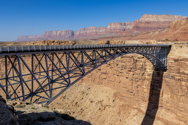
It might be
tight on time, depending on when you start your morning, but if you want to
combine some more remote hikes you can drive to Historic Navajo Bridge or Toadstool
Hoodoos.
3 Days Visit Planning:
Combine the one-day
itinerary above with longer daytrips, coming back afternoon/night back to page.
A day trip
proposals:
·
South Rim of the Grand Canyon
National Park
·
North Rim of the Grand Canyon
National Park
·
Lake Powell – water activity.
·
Wire Pass Trailhead and Buckskin
Gulch
·
White Pocket (need 4x4 car)
·
Driving Cottonwood Canyon Road to
Highway 12 (need 4x4 car)
·
Alstom Point (need 4x4 car)
·
Monument Valley and Mexican Hat
List of locations/destinations
with short description.
I added a link
to my specific blog (if I have such)
Near the city of Page:
Lower Antelope Canyon Tours
Visiting Antelope
Canyon became one of the “mast visit” destination when people are traveling to
the national parks of south Utah and North Arizona.
Lower Antelope
Canyon considered to be one of the most awe-inspiring landscapes there is in
this region. The deep canyon formed in the Navajo sandstone over millions of
years by water has resulted in the narrow twisting slot canyon with its
stunning formations, textures and shapes and palette of colors.
The slot canyon
views is breathtaking, with its smooth layered rock texture, twisting and
changing rock formation and the vibrant deep reds, purples, orange, yellow, pink,
and hues colors.
You just can’t
stop taking pictures.
Link to my blog
When we visit here,
we went to the lower canyon but there are other similar tours options for visiting
amazing slot canyons:
Upper Antelope, Antelope Canyon X,
and Waterhole Canyon Experience LLC
Lake Powell Marinas
Here you can
rent a Boat, jet ski or Kayak and spend a half/full day on the lake or even
rent a houseboat for several days.
The three
marinas at Lake Powel are Wahweap, Antelope Point, and Bullfrog (located far
to the north and not near Page AZ).
From Antelope
Point Marina you can get to the opening of Antelope canyon and walk some
section of the canyon up.
I did not do
any lake activities so can’t provide a lot of personal information.
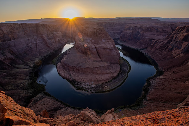
Horseshoe Bend
An iconic
"must see" viewing point of the mighty Colorado River canyon.
From the
viewing point the river is flowing about 1,000ft below you and it is doing a
huge U turn bend loop on its way downstream.
Horseshoe Bend
is considered to be one of the most photographed sites in northern Arizona and
there is a good reason for that.
Plan to spend
here about a 1 hour, if you are waiting for sunset this can be a lot longer
visit.
Link to my blog
Glen Canyon Dam Overlook
Visiting this almost
unknown viewpoint is very simple, short with excellent unique views of the
Colorado River canyon, in Page Arizona.
This can be
just 15-20 extension for your trip here, amazing reword for the short easy side
trip.


Comments
Post a Comment