
Introduction:
What? : The Hawaiʻi
Volcanoes National Park is designated International Biosphere Reserve and
UNESCO World Heritage Site.
In the park you
can see two of the most active volcanoes on earth; At its heart are the Kīlauea
and Mauna Loa active volcanoes.
The Park incorporates
diverse environments including seven ecological zones. From the basaltic ocean
coastline and expose lava flow plains, active volcanoes crater, deep lush rainforest and the high summit of the earth's largest in volume volcano, Mauna Loa.


Where? : The park is
located at the south east section of the Big Island, 45 minute drive south of Hilo.
Plan for 2 hours’ drive if you are coming from the northwest Kona side.
Google Map Link


Link to other Big Islands Blog posts:
- Kauai - Island Visit and Trip Planning
- Maui – Overview, Visit Planning and Tips
- Big Island – Overview, Visit Planning and Tips
- Big Island – Beaches, Northwest Ocean Shore
- Big Island - Waterfalls at Wailuku River State Park
- Big Island – Pepeekeo Maikai Scenic Route
- Big Island – Driving North of Hilo, Northeastern Ocean Shoreline
- Big Island - Akaka Falls State Park
- Big Island - Waipi'o Valley
- Big Island - Pololū Valley
- Big Island – Drive through the island central high section
- Big Island - Hawaiʻi Volcanoes National Park

Due note 1: There are many
different things to do, see and places to hike at this park. We went here for
one day and we did not manage to cover many things, my advice is to dedicate 2
days to this large park.
Due note 2: There are two
drive-in campgrounds within the park, as well as multiple options for
backcountry camping. Reservations and permits are required.
Due note 3: The Park is in
the rainy side of the island, come with rain gear (and even umbrellas) and with
warm cloth.
Due note 4: This Park is manage
by the US National Park so there is a fee station at the entrance, the America
the Beautiful National Parks permit is valid here.

Due note 5: The Park is
open 24 hours, especially popular for watching the glow from the active Halema’uma’u
volcano crater.
Due note 6: This is most
visited attraction in Hawaiʻi and the most visited volcano in the world, be
patient when driving and when waiting for free parking lot.

My thoughts: This large
park deserve more time than the only one full day we spend here, but we enjoy
it very much. Although it was raining throughout the entire day, and some
landscape viewings were completely covered with fog we had fun.
Unlike our low
expectations to be able to see a boiling lava we manage to get some clear
moments with less steams over the boiling melted rock crater.

The visit:
The Big Island
consists in total of five separate volcanoes: Kohala, Mauna Kea, Hualālai,
Mauna Loa and Kilauea.
Hawaii
Volcanoes National Park cover a large area of 505 square miles (1,308 square
km) at southeastern shore of the island of Hawaii, southwest of Hilo.
This is a huge
park that most of it is accessible to hikers only and roads are providing
limited access to the park large area.

Starting at the
sea level with long lava fields flowing into the ocean and ending at the high
alpine largest volcano by volume on earth mount Mauna Loa covers (13677 feet).
Kīlauea and its
Halemaʻumaʻu caldera were traditionally considered the sacred home of the
goddess Pele, the Hawaiian goddess of fire, lightning, wind, and volcanoes, and
Hawaiians visited the crater to offer gifts to the goddess.
As of 2022, most of the park is open to the public, although some road segments, trails, and museum are still close.

Few facts on the park Active Volcanoes:

Mauna Loa
This huge
mountain covers half of the island in the south-central area and visible from
many points in the Big Island. It is the largest volcano by volume on earth. It’s
summit is at 13,677 feet high. Although it is looking like a sleeping giant, Mauna
Loa has been active for nearly 700,000 years, and its most recent eruption was
in 1984.
Its 13,677 feet
high summit caldera is 2 by 3 miles and 600 feet deep. In 1950 a lava flow from
the volcano’s southwestern reached the ocean in less than three hours, covering
the distance at a speed of 5.8 miles (9.3 km) per hour. Mauna Loa’s most recent
eruption was in 1984.
Kilauea:
This mountain stands
east of Mauna Loa and is considered to be the world's most active volcano. This
is also Hawaii's youngest volcano so its summit is not as impressive as other Hawaii
volcanoes (4,090 feet high). The Halema'uma'u Crater, located within the shield
volcano's caldera, is the volcano's most active vent.

In 2018, one
Kilauea erupted for more than a month on it east rift zone. This eruption and
the mass of lava flow destroyed hundreds of homes and residential neighborhoods
at nearby small towns. At the eruption the top of the mountain walls fall into
itself, collapsed 2,000 feet of the crater's summit. This event created huge Caldera
crater, 2.5 miles long and 2 miles wide with a deep Halemaumau active crater,
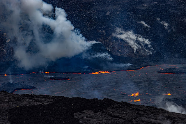
where lava is still boiling today.

Park Weather:
Being on the southeastern
rainy side of the Big Island the park receive a lot of rain, nearly 100 inches
(2,500 mm) of rainfall annually.
Visitors to the
park should come prepared for rain any time of the year.
Because this is
around 4,000 feet elevation the temperature here are much colder than near the
sea level.
Come with rain gear (and even umbrellas) and with warm cloth.


Our visit description:
We spend here
only one full day, but we enjoy it very much. Although it was raining
throughout the entire day, we had fun.
We started our
day late; I took us 2 hours’ drive from our northeast Kona hotel to the park
visitor center. We arrive to the visitor center relatively late (almost near noon).
We had a short
stop at the visitor center (where we parked our cars), checked with a ranger
about recommend trail options and volcano activity.
We went to a short
2-miles easy hike to the nearby Sulphur Banks Trail.


From here we
drove to Kilauea Iki Overlook parking lot. From this point you can look at the 3-mile-wide
Kilauea Iki Crater. From here we hiked along the create rim to the Nahuku Lava
Tube.

After the Lava Tube hike, we drove to Keanakako'i Overlook parking lot (on Crater Rim drive), this is a packed parking lot so you may not find where to park here. You can also park at Puʻupuaʻi overlook parking and hike 0.5 mile to this place. From Keanakako'i Overlook parking lot we hiked 1 mile on the old create rim drive road (close to all traffic) to Hale Ma'uma'u Volcano Crater overlook point.


This is the
closest point you can see the active crater and red boiling lava pool. It was
almost dark when we went back to our car (winter short days).
It was already
6pm when we left the park and, on our way, back, we stop for dinner at nearby
restaurant. Another 2 hours drive at night, in rain and fog, and we were back
at our hotel. Interesting, once we cross the high point of our drive west the
weather changed completely, the rain and fog vanished, and we had a clear sky.
As you can see
you can do a lot and visit many places in one day trip to Volcanoes National
Park.
Trips you can do by Car:
There are
several car-drives you can do in the park:
·
Short Crater Rim Drive all the way to the last viewpoint, the drive passes steam vents (you can stop here and have short hikes) and
a viewpoint overlooking Halema'uma'u Crater.

·
Drive 22 miles on Chine of Craters Road all the way to
the ocean frontline and Hōlei Sea Arch. There are many long hiking options to
nearby volcano craters along this road. We did not have the time to drive this
road so I will not provide more information.
·
Drive along highway 11 outside the
park boundaries, along the way you can visit the famous Punaluʻu Black Sand Beach
or even stop in the remote section of the park at Hawaii Volcanoes National
Park Kahuku Unit. We did not have the time to drive this road so I will not
provide more information.
·
Drive to Kalapana on Highway 130, this is
outside the park but here at the end of the road you can see how the volcano
lava flow cover the small towns in this area. We did not have the time to drive
this road so I will not provide more information.
Recommended short Hikes:
1. Sulphur Banks Trail:
This is family
friendly easy 1.2 mile hike on a paved trail and boardwalks.
The trail starts
right at the park Kilauea Visitor Center. Keep walking west at the same side of
the road and you will find the trailhead just after the parking lot.


This hike will
take you through a nice section of rainforest and after a short hike you will
get into open section where you can see the Sulphur Banks. Hot steam and volcanic
Sulphur fumes going out of the ground, giving this place the smell of rotten
eggs.

This open
section is the most impressive section. The trail getting into another forest
section and out into the open again, after walking 0.7 mile you will reach to
Rim Drive Road. here you can go back the same way or cross the road and go back
on a the parallel to the road Rim hiking trail.
Overall, this
is a fun easy hike with interesting geological things to see.

2. Crater Rim Trail:
There are
several connectors trail along the rim of the craters, this specific hike starts
near the main park Kilauea Visitor Center (across the road and pass the Volcano
House). The trail is following the rim, parallel to the road, a 1-mile
trail is leading to the direction of Kilauea Iki crater in the south.

Nahuku Lava Tube:
There are two
option to hike here, the first one is to park your car just near the cave at Parking
at Nāhuku (Thurston Lava Tube) roadside parking. It is almost impossible to find
parking spot here !
The second one,
and preferred, is to park your car at Kilauea Iki Overlook parking lot.
A 0.5-mile hike
along the Kilauea Iki Crater rim will bring you to the cave parking lot.
The lava tube
is lit 8 a.m. to 8 p.m.

Restrooms near
the lava tube (when coming from the road they are at your left, or at the end
of the hiking loop) are open from 9 a.m. to 5 p.m.
The short,
paved trail start from the road, turn right, and go down into the rainforest jungle
and large ferns vegetation. Soon you will get to the cave entrance. This cave
is 500-year-old lava tube where a river of melted rocks flowed and left behind
the cave space.


Cross the small
bridge and enter the cave, the cave has yellow light from lamps on the walls,
so you do not need to have flashlight.

he
600-foot-long cave has a flat rock floor and a high ceiling, so it is not
challenge at all.
After short
hike you will reach the end of the cave, climb up and out into the jungle. Keep
hiking the short trail back to the road (you will see the restrooms on your
right).
3. Devastation Trail:
The Devastation
Trail start from the parking lot to Puʻupuaʻi Overlook, via a one-mile out and
back walk on a paved path.
The area was covered
by the 1,900-foot-tall lava fountains during the 1959 eruption. The trail
provides views of the new cinder cone, Puʻupuaʻi, that developed during the
five-week eruption.
4. Hale Ma'uma'u Volcano Crater
overlook point:
Park at Devastation
small parking lot, where Crater Rim Road turn left into Chine of Craters Road. The
old Rim Road that in the past kept going straight is close to all traffic.

From here you
will walk 1 mile on the close road. In some places you can see hoe the road was
crack as of result of the 2018 eruption. After a mile you will clearly see a
side marked trail to your right. Here you will leave the road and walk to the cliff
edge viewing point.

Due to safety
restrictions, you are not able to view Halema’uma’u crater and lava lake up
close, it can be viewed from afar.


We visit here
at a rainy day, the rain, low clouds, and steams cover the lake for most of the
time. After 20 minute the view cleared, and we manage to get a good glimpse of
the impressive, melted lava lake.
This was my
first time seeing boiling hot lava and the sight was impressive.
We spend here
almost 40 min and after we had enough, we start to walk back to our cars.
Nighttime is
the best time to visit the crater, when you can see its red glow much better.

5. Kilauea Iki Crater Trail:
This is a 4-miles hike with 400 feet of descending and climbing, at the loop trail the recommended route is counterclockwise.
We did not have
the time to hike here.


In the past, in
1959, this was a boiling lava lake created from 5 weeks eruption. After time
the melted lava get colder. The trail descending into the crater and cross it
from one side to the other.
https://www.nps.gov/havo/planyourvisit/upload/kilauea-iki-trail-guide-2013.pdf

We had a lot of
fun at this one-day visit in this amazing park.
There are many
more places and things to do in the park, one day is just to taste what this
park can offer. We will probably do them at our next visit to this amazing
park...
www:
https://www.nps.gov/havo/index.htm
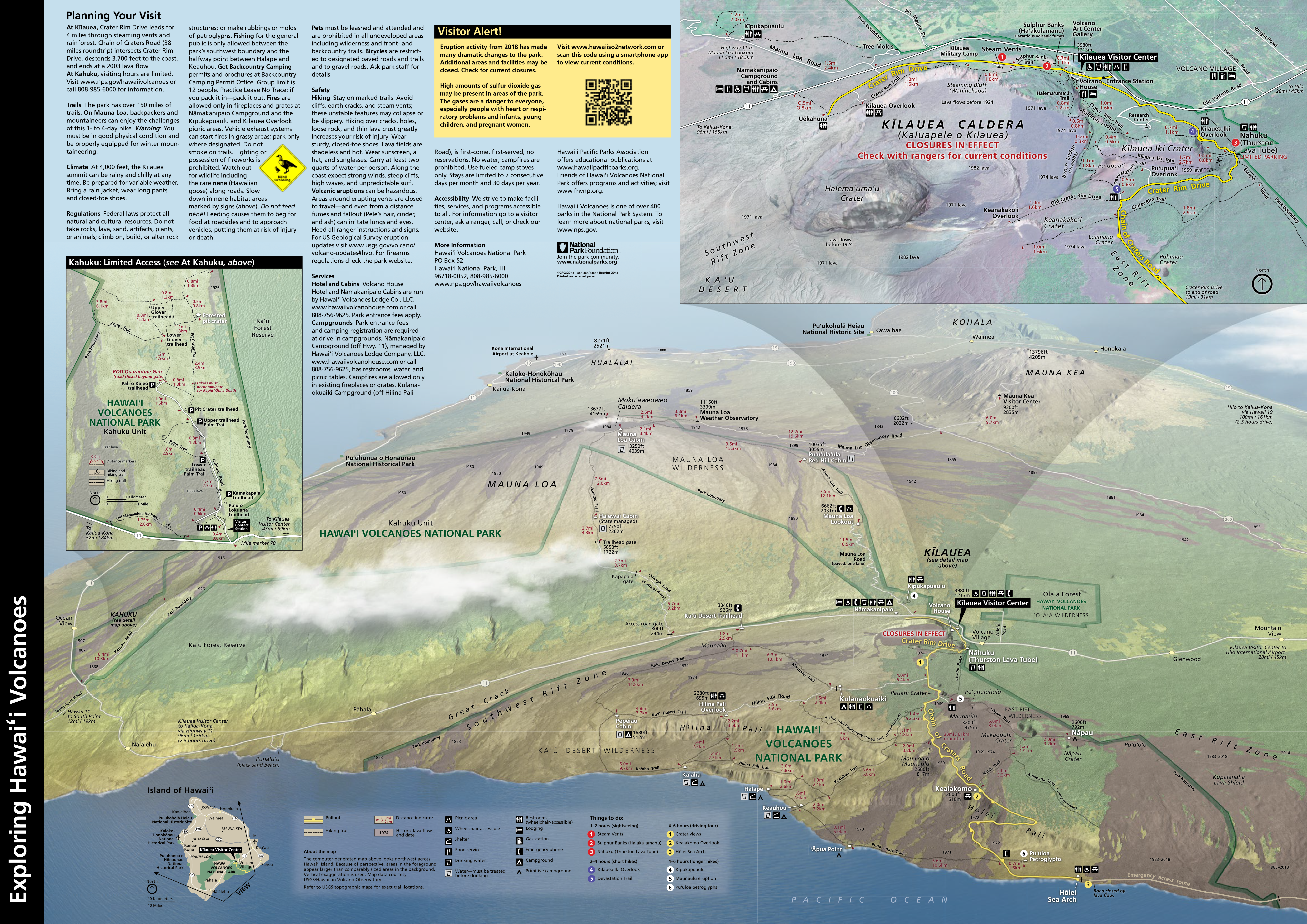
Map:
https://www.nps.gov/havo/planyourvisit/images/HAVO_S2_FinalParkReview2.png
More Pictures:


Comments
Post a Comment