
Introduction:
What? : Large sand
dunes, cinder cone volcanoes, the largest Joshua tree forest in the world, long-abandoned
mines, and endless desert wilderness landscape can be found within this
1.6-million-acre Mojave National Preserve.
Additional Related Blogs:
Joshua Tree National Park – Visit planningMojave Desert – Amboy CA, historic Route 66Mojave National Preserve – visit planning, 2 days trip itinerary
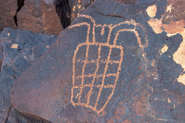
Mojave National Preserve – Cow Cove Petroglyphs


Located in
eastern California, North of Joshua Tree and south of Death Valley, Mojave
National Preserve is the heart of the much larger Mojave Desert.
Here you will
be able to find interesting sites to visit while keeping away from the crowded
roads and get the feeling that the desert is all yours.
Where? : located east
of Barstow CA to the Arizona border, between Highway I-15 on the north to Highway
I-40 on it south side.
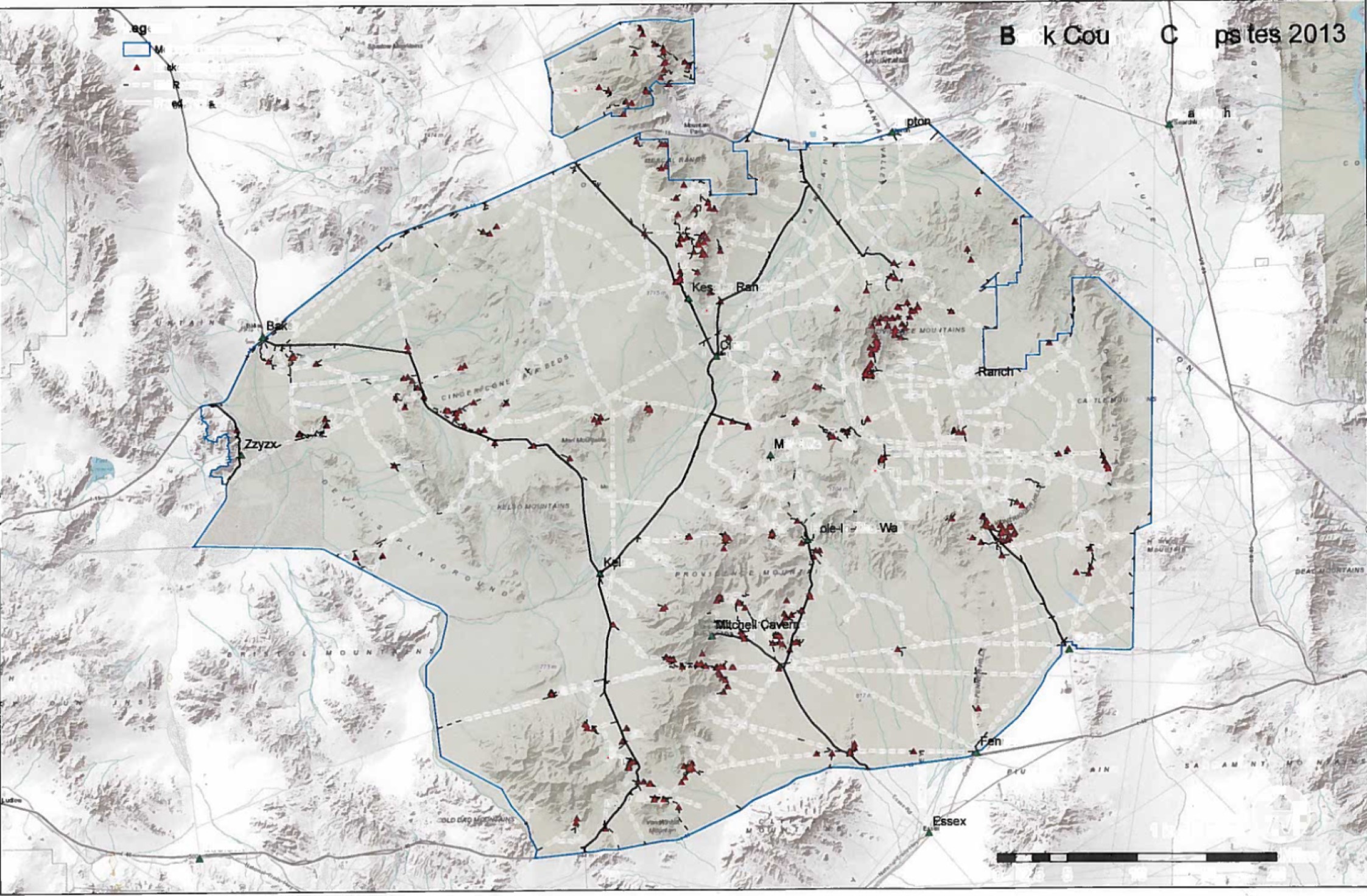
Google Map Link


When? : Late fall, winter
and spring is the preferred time to visit the Mojave desert, summer is just too
hot.
Due note 1: Water - Always take
more than what you think you need, this is desert and temperature can be hot,
in summer this is extremely hot environment.
Due note 2: Drive with enough
fuel, no gas station in Mojave National Preserve
Due note 3: No cellular reception
in Mojave National Preserve (you may have receptions near the main Highways). If
you are using cellular map with GPS make sure you download the map in advance
where you have cell reception (Wi-Fi connectivity is preferred).
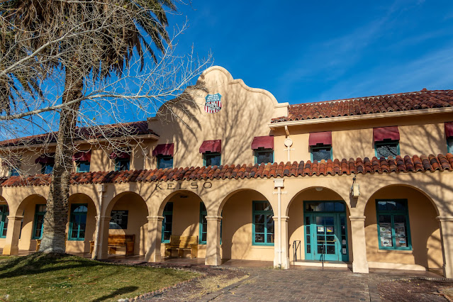
Due note 4: The Kelso
Depot main park Visitor Center is currently close. Reopening anticipated Spring
2023. Visitor services are available at Hole-In-The-Wall Information Center
Friday to Monday 10am to 4 pm
My thoughts: Every time I visit
here, I’m telling myself that I must visit here more.
Unlike similar
parks like Joshua Tree NP and Death Valley NP that are “famous” but can be overcrowded,
here you see a lot less people and you get the feeling that it is only you in
the vast desert.
There are many things
to see and do here, remote 4x4 off-road trails, deserted mines, Petroglyphs, and
probably the best sand dunes experience in the Mojave desert of southeast
California.
Plan Your Visit:
The Desert
Protection Act created the 1.4-million-acre Mojave National Preserve in the
heart of the Mojave Desert. This act transferred the lands known as the East
Mojave National Scenic Area to the National Park Service.
The desert in
the Mojave National Preserve ranges in elevation from less than 1000 feet to
almost 8000 feet.
Summer
temperatures are in the triple digits, making November through early May the
best time to visit the park.
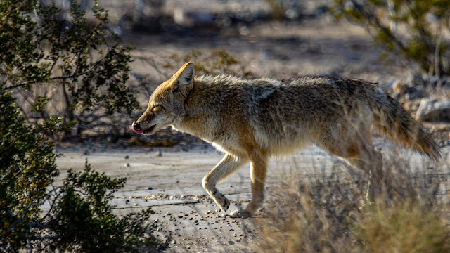
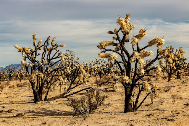
Mojave National
Preserve has a larger dune field than Death Valley NP, has more Joshua trees
than in Joshua Tree NP, wildlife is abundant, and you can find here over 300
different species of animals.
Situated in southeastern
part of California, north of Joshua Tree and south of Death Valley. Mojave
National Preserve resembles a bit of both. Since it is not a national park it is
relatively short on facilities and has much less visitors, but this absence
creates the opportunity for a more intimate desert visit.
Few important
aspects you need to be aware of when you are planning your visit here: Temperatures,
Driving and gas, accommodation options (hotels or campsites), off-road driving.
Weather:
Summers are
hot, and temperatures above 100 degrees Fahrenheit are typical. In cold winter
day, around freezing temperatures at night with some time rain and snow in the
mountains.
Annual
precipitation ranges from 3.5 inches at lower elevations to nearly 10 inches in
the mountains. Most rain falls between November and April, summer thunderstorms
may bring sudden, heavy rainfall.
Gas stations:
You do not want to get stack
without gas at the Mojave Desert!
There are no
gas stations within Mojave National Preserve, make sure you fill your gas tank:
·
When leaving Barstow or on the main
highways (I-15 or I-40)
·
When driving east on I-15 there are
several exits with gas stations, the last one is at Baker (exit 245)
·
When driving east on I-40 you can
fill up gas at Ludlow (exit 50)
·
When driving from/to Joshua Tree
National Park you can fill up gas at Amboy (old Route 66)
·
When coming from Arizona on I-40
fill your gas at Needles.
Where to sleep near the Preserve:
When coming
from the west the main place to sleep near Mojave National Preserve is at the
city of Barstow, here you can find many options for night stay.
When coming
from Las Vegas Nevada on Highway I-15 you can spend the night at the border Nevada/California
at Primm Nevada.
When coming
from the east and Arizona on Highway I-40 Needles is the only choice to have
proper hotel for the night
Nipton: Located
on the northeastern border of Mojave National Preserve, approximately 12 miles
southeast of Primm, Nevada. You can find here few options for non-commercialized
night accommodations and enjoy the desert art statues.
Developed campgrounds
Although the preserve
is huge in size there are only two developed campgrounds in Mojave National
Preserve.
Thy are both available
year-round, equipped with toilets, trash receptacles, fire rings and picnic
tables.
Each campsite
can accommodate up to 8 people per site. Groups larger than 14 people will need
to make reservations for the group campground at Black Canyon. All individual
developed campgrounds are first-come, first-served.
Hole-in-the-Wall Campground
At 4,400 feet
in elevation, Hole-in-the-Wall Campground is surrounded by sculptured volcanic
rock walls and makes a great basecamp for hikers. 35 campsites accommodate RVs
and tents; two walk-in sites are also available.
Facilities: Pit
toilets, trash receptacles, fire rings, picnic tables; no utility hookups.
Fees: $12 per
site per night, campground fees are payable by self-registration with cash or
check at the entrance kiosk. There is no change available. If using cash as
payment, please bring exact change.
Mid Hills Campground:
At 5,600 feet
in elevation, Mid Hills is much cooler than the desert floor below. The access
road is unpaved and but in good condition for regular car, it is not
recommended for motorhomes or trailers.
A Fire swept
through the area in 2005, burning much of the vegetation, most tress around the
camp are dead. The unburned section is located at the back of Mid Hills
Campground. There are 26 campsites, last time I visit here (Jan 2022) they are
all in excellent condition.
There are pit
toilets, fire rings, picnic tables in every campsite.
Mid Hills
Campground has no water!
Fees: $12 per
site per night, campground fees are payable by self-registration with cash or
check at the entrance kiosk. There is no change available. If using cash as
payment, please bring exact change.
Detailed information
and map on Developed campgrounds:
https://www.nps.gov/moja/planyourvisit/upload/camping_sb_bl-4-26-CS5-low.pdf
Kelso Dunes camping:
Camping at the
Dunes trailhead is not allowed.
Camping is
allowed only at established undeveloped campsites 1 mile from the trailhead.
All sites are first come, first serve.
Guidelines for primitive campsites:
Camping in
undeveloped campsites is allowed in previously used or disturbed sites outside
of the "day-use-only" areas.
In most cases
these sites include a rock or metal fire ring; not all sites contain a fire
ring. All fires must be in a fire ring or fire pan; new fire rings cannot be
constructed. Camping tramples vegetation and disturbs soils.
By reusing
existing sites, you help protect the desert from further damage.
Leave primitive
campsites better than you found them.
Pack out all waste,
including toilet paper. Toilet paper takes a very long time to decompose in the
desert, and animals or wind tend to unearth it before it can break down.
Primitive
campsites map:
https://www.nps.gov/moja/planyourvisit/images/camping-map_1.jpg


Off-road 4x4 Driving:
Mojave has
hundreds of miles of off-pavement trails for 4X4s cars, the most famous one is
the 150 miles Mojave Drive Route that crosses the desert all the way from
Arizona border to the Sierra mountains.
Few notes about off-road driving:
For any long off-road
driving activity, you must plan a head and know what you are doing!
Understand you’re
driving abilities and your car limitations and analyze the driving conditions
all the time. Think what if I need to turn around, can I make it back out.
Do not think “if
I can pass it?” but rather “what I will do if I get stack?”.
Things can “just”
happen, you may have flat tire or other car malfunction, you can get stack in “simple”
to pass places, in mud, deep send or river bad, the road can be un-passable, or
you may even lose your way in the desert.
It is not about
pride, if the road gets too rough for you, turn around!
In the event of
an emergency, for un-trained people, staying with your car is probably the most
important thing you can do.

Make sure you
have a proper map and that you know how to navigate.
Know how to use
your gear, change flat tire or how to drive in deep send or mud conditions.
Garmin
satellite phone is always good to have with you for emergency and map.
Make sure you
have a basic First-Aid kit and that you do know how to use it.
Do not travel
cross-country or create new routes. This rule is strictly enforced; violators
will receive citations. Driving in washes is not permitted.
In Mojave
National Preserve, Groups of more than 7 vehicles or 25+ people require a
Special Use Permit.
Important Notice: ATVs and UTVs
Not Permitted in Mojave National Preserve at all!
Places to visits and things to do at
Mojave National Preserve:
I wrote many separate
and detailed blogs on places to visit and things to do in the Preserve.
Two-wheel drive
vehicles will not have a problem visiting many of the attractions, campsites,
and most locations I stated below, few do need 4x4 high clearance car.
See below links
to the specific blog or look at my main blog map for specific location:
Mojave National Preserve – Barstow


Mojave National Preserve – Baker


Mojave Desert – Highway 127 from Death Valley to Baker


Mojave National Preserve – Lava Tube


Mojave National Preserve – Aiken Mine Road (4x4 drive)


Mojave National Preserve – Cow Cove Petroglyphs (4x4 drive)


Mojave National
Preserve – Cima Dome & Joshua Tree Forest


Mojave National Preserve – Drive from Cima Rd to Hole-in-the-Wall


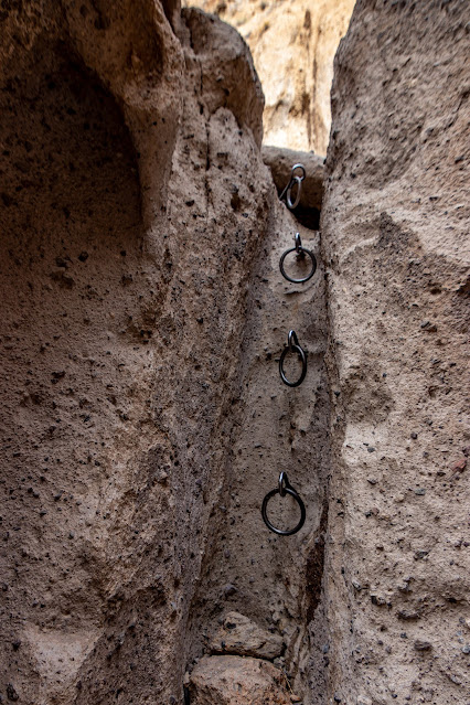
Mojave National Preserve – Hole-in-the-Wall

Mojave National Preserve – Drive from Essex Road to Kelso Dunes (4x4 drive)


Mojave National Preserve – Kelso Dunes


Mojave National Preserve – Kelso Depot

Mojave Desert –
Amboy CA, historic Route 66
I also wrote a
detailed itinerary blog on my latest 2 days trip to Mojave National Preserve; I
visit here in January 2022 and enjoy it very much:
Mojave National Preserve – visit planning, 2 days trip itinerary
Mojave Road 4-Wheel Drive Route
(did not drove it)
The Mojave Road
is an east-west route, roughly 150 miles long, that traverses the desert
between the Colorado River and the Mojave River near Wilmington, Los Angeles,
CA. Most of the Mojave Road is within the boundaries of the Mojave National
Preserve. The road enters the park near Piute Spring on the east side and on
Soda Dry Lake near Zzyzx on the west. The road is not regularly maintained, and
some sections are rough and sandy; 4 x 4 is recommended. If visitors wish to
drive the entire length of the road, usually 3 days are required.
Additional places I did not visit
yet:
Afton Canyon
Zzyzx and Soda
Springs:
The last alphabetically
ordered entry for all geographic place. Mineral and Heath Spa, now the Desert
Studies Center. There’s a surprisingly large pool with a fountain and lots of
ducks, some nice facilities, and a view across the dry Soda Lake.
Camp Rock Spring
Fort Piute
Trail
Providence
Mountains State Recreation Area and Mitchell Caverns:
Located at the north-western
end of Essex Road not so far from Hall-in-the-Wall site. I never visit here but
from reading online it looks like it worth the time. Make sure to check prior
your visit about opening hours and tour reservations at:
https://www.parks.ca.gov/?page_id=615
Goffs:
Unincorporated
community in San Bernardino County, California, is a nearly empty one-time
railroad town at the route's high point in the Mojave Desert.
Nipton:
Unincorporated
community in the Ivanpah Valley with a population of about 15 – 20. Located on
the northeastern border of Mojave National Preserve, approximately 12 miles
southeast of Primm, Nevada. You can find here few options for night accommodations
and see the desert art statues.
I hope that you
will find this blog informative and that it helps you plan your next Mojave
National Preserve adventure.
www:
https://www.nps.gov/moja/index.htm
Map:
https://www.nps.gov/moja/planyourvisit/upload/mojamap1.pdf
Pictures:


Located in
eastern California, North of Joshua Tree and south of Death Valley, Mojave
National Preserve is the heart of the much larger Mojave Desert.
Here you will
be able to find interesting sites to visit while keeping away from the crowded
roads and get the feeling that the desert is all yours.
Where? : located east
of Barstow CA to the Arizona border, between Highway I-15 on the north to Highway
I-40 on it south side.
Google Map Link

When? : Late fall, winter
and spring is the preferred time to visit the Mojave desert, summer is just too
hot.
Due note 1: Water - Always take
more than what you think you need, this is desert and temperature can be hot,
in summer this is extremely hot environment.
Due note 2: Drive with enough
fuel, no gas station in Mojave National Preserve

Due note 3: No cellular reception
in Mojave National Preserve (you may have receptions near the main Highways). If
you are using cellular map with GPS make sure you download the map in advance
where you have cell reception (Wi-Fi connectivity is preferred).
Due note 4: The Kelso
Depot main park Visitor Center is currently close. Reopening anticipated Spring
2023. Visitor services are available at Hole-In-The-Wall Information Center
Friday to Monday 10am to 4 pm
My thoughts: Every time I visit
here, I’m telling myself that I must visit here more.
Unlike similar
parks like Joshua Tree NP and Death Valley NP that are “famous” but can be overcrowded,
here you see a lot less people and you get the feeling that it is only you in
the vast desert.
There are many things
to see and do here, remote 4x4 off-road trails, deserted mines, Petroglyphs, and
probably the best sand dunes experience in the Mojave desert of southeast
California.

Plan Your Visit:
The Desert
Protection Act created the 1.4-million-acre Mojave National Preserve in the
heart of the Mojave Desert. This act transferred the lands known as the East
Mojave National Scenic Area to the National Park Service.
The desert in
the Mojave National Preserve ranges in elevation from less than 1000 feet to
almost 8000 feet.
Summer
temperatures are in the triple digits, making November through early May the
best time to visit the park.
Mojave National
Preserve has a larger dune field than Death Valley NP, has more Joshua trees
than in Joshua Tree NP, wildlife is abundant, and you can find here over 300
different species of animals.
Situated in southeastern
part of California, north of Joshua Tree and south of Death Valley. Mojave
National Preserve resembles a bit of both. Since it is not a national park it is
relatively short on facilities and has much less visitors, but this absence
creates the opportunity for a more intimate desert visit.
Few important
aspects you need to be aware of when you are planning your visit here: Temperatures,
Driving and gas, accommodation options (hotels or campsites), off-road driving.

Weather:
Summers are
hot, and temperatures above 100 degrees Fahrenheit are typical. In cold winter
day, around freezing temperatures at night with some time rain and snow in the
mountains.
Annual
precipitation ranges from 3.5 inches at lower elevations to nearly 10 inches in
the mountains. Most rain falls between November and April, summer thunderstorms
may bring sudden, heavy rainfall.


Gas stations:
You do not want to get stack
without gas at the Mojave Desert!
There are no
gas stations within Mojave National Preserve, make sure you fill your gas tank:
·
When leaving Barstow or on the main
highways (I-15 or I-40)
·
When driving east on I-15 there are
several exits with gas stations, the last one is at Baker (exit 245)
·
When driving east on I-40 you can
fill up gas at Ludlow (exit 50)
·
When driving from/to Joshua Tree
National Park you can fill up gas at Amboy (old Route 66)
·
When coming from Arizona on I-40
fill your gas at Needles.

Where to sleep near the Preserve:
When coming
from the west the main place to sleep near Mojave National Preserve is at the
city of Barstow, here you can find many options for night stay.
When coming
from Las Vegas Nevada on Highway I-15 you can spend the night at the border Nevada/California
at Primm Nevada.
When coming
from the east and Arizona on Highway I-40 Needles is the only choice to have
proper hotel for the night
Nipton: Located
on the northeastern border of Mojave National Preserve, approximately 12 miles
southeast of Primm, Nevada. You can find here few options for non-commercialized
night accommodations and enjoy the desert art statues.

Developed campgrounds
Although the preserve
is huge in size there are only two developed campgrounds in Mojave National
Preserve.
Thy are both available
year-round, equipped with toilets, trash receptacles, fire rings and picnic
tables.
Each campsite
can accommodate up to 8 people per site. Groups larger than 14 people will need
to make reservations for the group campground at Black Canyon. All individual
developed campgrounds are first-come, first-served.
Hole-in-the-Wall Campground
At 4,400 feet
in elevation, Hole-in-the-Wall Campground is surrounded by sculptured volcanic
rock walls and makes a great basecamp for hikers. 35 campsites accommodate RVs
and tents; two walk-in sites are also available.
Facilities: Pit
toilets, trash receptacles, fire rings, picnic tables; no utility hookups.
Fees: $12 per
site per night, campground fees are payable by self-registration with cash or
check at the entrance kiosk. There is no change available. If using cash as
payment, please bring exact change.

Mid Hills Campground:
At 5,600 feet
in elevation, Mid Hills is much cooler than the desert floor below. The access
road is unpaved and but in good condition for regular car, it is not
recommended for motorhomes or trailers.
A Fire swept
through the area in 2005, burning much of the vegetation, most tress around the
camp are dead. The unburned section is located at the back of Mid Hills
Campground. There are 26 campsites, last time I visit here (Jan 2022) they are
all in excellent condition.
There are pit
toilets, fire rings, picnic tables in every campsite.
Mid Hills
Campground has no water!
Fees: $12 per
site per night, campground fees are payable by self-registration with cash or
check at the entrance kiosk. There is no change available. If using cash as
payment, please bring exact change.
Detailed information
and map on Developed campgrounds:
https://www.nps.gov/moja/planyourvisit/upload/camping_sb_bl-4-26-CS5-low.pdf

Kelso Dunes camping:
Camping at the
Dunes trailhead is not allowed.
Camping is
allowed only at established undeveloped campsites 1 mile from the trailhead.
All sites are first come, first serve.

Guidelines for primitive campsites:
Camping in
undeveloped campsites is allowed in previously used or disturbed sites outside
of the "day-use-only" areas.
In most cases
these sites include a rock or metal fire ring; not all sites contain a fire
ring. All fires must be in a fire ring or fire pan; new fire rings cannot be
constructed. Camping tramples vegetation and disturbs soils.
By reusing
existing sites, you help protect the desert from further damage.
Leave primitive
campsites better than you found them.
Pack out all waste,
including toilet paper. Toilet paper takes a very long time to decompose in the
desert, and animals or wind tend to unearth it before it can break down.
Primitive
campsites map:
https://www.nps.gov/moja/planyourvisit/images/camping-map_1.jpg

Off-road 4x4 Driving:
Mojave has
hundreds of miles of off-pavement trails for 4X4s cars, the most famous one is
the 150 miles Mojave Drive Route that crosses the desert all the way from
Arizona border to the Sierra mountains.
Few notes about off-road driving:
For any long off-road
driving activity, you must plan a head and know what you are doing!
Understand you’re
driving abilities and your car limitations and analyze the driving conditions
all the time. Think what if I need to turn around, can I make it back out.
Do not think “if
I can pass it?” but rather “what I will do if I get stack?”.
Things can “just”
happen, you may have flat tire or other car malfunction, you can get stack in “simple”
to pass places, in mud, deep send or river bad, the road can be un-passable, or
you may even lose your way in the desert.
It is not about
pride, if the road gets too rough for you, turn around!
In the event of
an emergency, for un-trained people, staying with your car is probably the most
important thing you can do.
Make sure you
have a proper map and that you know how to navigate.
Know how to use
your gear, change flat tire or how to drive in deep send or mud conditions.
Garmin
satellite phone is always good to have with you for emergency and map.
Make sure you
have a basic First-Aid kit and that you do know how to use it.
Do not travel
cross-country or create new routes. This rule is strictly enforced; violators
will receive citations. Driving in washes is not permitted.
In Mojave
National Preserve, Groups of more than 7 vehicles or 25+ people require a
Special Use Permit.
Important Notice: ATVs and UTVs
Not Permitted in Mojave National Preserve at all!

Places to visits and things to do at
Mojave National Preserve:
I wrote many separate
and detailed blogs on places to visit and things to do in the Preserve.
Two-wheel drive
vehicles will not have a problem visiting many of the attractions, campsites,
and most locations I stated below, few do need 4x4 high clearance car.
See below links
to the specific blog or look at my main blog map for specific location:
Mojave National Preserve – Barstow
Mojave National Preserve – Baker
Mojave Desert – Highway 127 from Death Valley to Baker
Mojave National Preserve – Lava Tube
Mojave National Preserve – Aiken Mine Road (4x4 drive)
Mojave National Preserve – Cow Cove Petroglyphs (4x4 drive)
Mojave National
Preserve – Cima Dome & Joshua Tree Forest
Mojave National Preserve – Drive from Cima Rd to Hole-in-the-Wall
Mojave National Preserve – Hole-in-the-Wall
Mojave National Preserve – Drive from Essex Road to Kelso Dunes (4x4 drive)
Mojave National Preserve – Kelso Dunes
Mojave National Preserve – Kelso Depot
Mojave Desert –
Amboy CA, historic Route 66
I also wrote a
detailed itinerary blog on my latest 2 days trip to Mojave National Preserve; I
visit here in January 2022 and enjoy it very much:
Mojave National Preserve – visit planning, 2 days trip itinerary
Mojave Road 4-Wheel Drive Route
(did not drove it)
The Mojave Road
is an east-west route, roughly 150 miles long, that traverses the desert
between the Colorado River and the Mojave River near Wilmington, Los Angeles,
CA. Most of the Mojave Road is within the boundaries of the Mojave National
Preserve. The road enters the park near Piute Spring on the east side and on
Soda Dry Lake near Zzyzx on the west. The road is not regularly maintained, and
some sections are rough and sandy; 4 x 4 is recommended. If visitors wish to
drive the entire length of the road, usually 3 days are required.

Additional places I did not visit
yet:
Afton Canyon
Zzyzx and Soda
Springs:
The last alphabetically
ordered entry for all geographic place. Mineral and Heath Spa, now the Desert
Studies Center. There’s a surprisingly large pool with a fountain and lots of
ducks, some nice facilities, and a view across the dry Soda Lake.
Camp Rock Spring
Fort Piute
Trail
Providence
Mountains State Recreation Area and Mitchell Caverns:
Located at the north-western
end of Essex Road not so far from Hall-in-the-Wall site. I never visit here but
from reading online it looks like it worth the time. Make sure to check prior
your visit about opening hours and tour reservations at:
https://www.parks.ca.gov/?page_id=615
Goffs:
Unincorporated
community in San Bernardino County, California, is a nearly empty one-time
railroad town at the route's high point in the Mojave Desert.
Nipton:
Unincorporated
community in the Ivanpah Valley with a population of about 15 – 20. Located on
the northeastern border of Mojave National Preserve, approximately 12 miles
southeast of Primm, Nevada. You can find here few options for night accommodations
and see the desert art statues.

Summary:
I hope that you
will find this blog informative and that it helps you plan your next Mojave
National Preserve adventure.
www:
https://www.nps.gov/moja/index.htm
Map:
https://www.nps.gov/moja/planyourvisit/upload/mojamap1.pdf
Pictures:
Comments
Post a Comment