
Introduction:
What? : A 21 miles dirt-road
drive through the desert, from Cima dome plateau, into a mountains and to Hole-in-the-Wall.
If you are not visiting at or right after major rain or flooding event this
drive can be done with regular car, only specific section of a side road is for
4x4 cars.
Related blogs:
Mojave National Preserve – Cima Dome & Joshua Tree ForestMojave National Preserve – Hole-in-the-Wall
Mojave National Preserve – visit planning, 2 days trip itinerary
Mojave National Preserve – Visit Planning

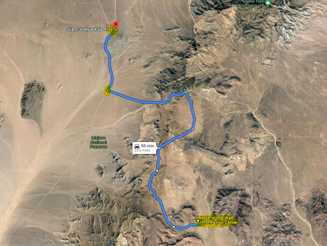
Where? : The drive
starts at Cima Rd. junction with Kalso Cima Rd.
Google Map Link

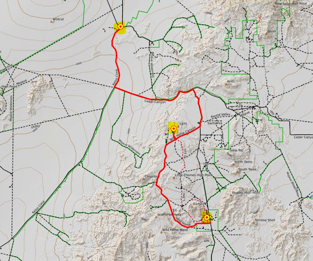
Trip without any need for 4x4 car

Trip with section of 4x4 Offroad
When? : Late fall, winter
and spring is the preferred time to visit the Mojave desert, summer is just too
hot.
Due note 1: Water - Always take
more than what you think you need, this is desert and temperature can be hot,
in summer this is extremely hot environment.

Due note 2: Few notes about off-road
driving:
For any long off-road
driving activity, you must plan a head and know what you are doing!
Understand you’re
driving abilities and your car limitations and analyze the driving conditions
all the time. Think what if I need to turn around, can I make it back out.
Do not think “if
I can pass it?” but rather “what I will do if I get stack?”.
Things can “just”
happen, you may have flat tire or other car malfunction, you can get stack in “simple”
to pass places, in mud, deep send or river bad, the road can be un-passable, or
you may even lose your way in the desert.
It is not about
pride, if the road gets too rough for you, turn around!
In the event of
an emergency, for un-trained people, staying with your car is probably the most
important thing you can do.
Make sure you
have a proper map and that you know how to navigate.
Know how to use
your gear, change flat tire or how to drive in deep sand or mud conditions.
Garmin
satellite phone is always good to have with you for emergency and map.
Make sure you
have a basic Firs-Aid kit and that you do know how to use it.
Do not travel
cross-country or create new routes. This rule is strictly enforced; violators
will receive citations. Driving in washes is not permitted.
In Mojave
National Preserve, Groups of more than 7 vehicles or 25+ people require a
Special Use Permit.
Important Notice: ATVs and UTVs
Not Permitted in Mojave National Preserve at all!

Due note 3: Drive with enough
fuel, no gas station in Mojave National Preserve
Due note 4: No cellular reception
in Mojave National Preserve (you may have receptions near the main Highways). If
you are using cellular map with GPS make sure you download the map in advance
where you have cell reception (Wi-Fi connectivity is preferred).
Due note 5: Only few paved
roads cross the Mojave Desert, most main dirt roads are in good conditions, but
some may be impossible to pass after heavy rain. There are many off-road, 4x4 only
trails, make sure you know what you are doing and what your car can handle safely.
Due note 6: This road, although
can be done by regular car (if not wet or muddy) it is not recommended for
motorhomes or trailers.
Due note 7: You can drive
to Hole-in-the-Wall on paved road, no need to drive on dirt road if you do not
want to do this trip, see: my Hole-in-the-Wall Blog.
Due note 8: During winter
month, bring with you few warm cloths, you may get warm during the day and the hike,
but you will need them once the sun is going down in a cold evening.
My thoughts: Easy to drive
road when it is dry, it will lead you from the relatively leveled sandy desert section
near Cima dome into the high mountain section of the preserve.

The Drive:
The road starts
at the Cima Rd. junction with Kalso Cima Rd, here you can see the train tracks that
are leading to Navada.
Near the
junction you can see an isolated home and old deserted Cima Store. Not a lot
more than that.

Mile 4.7:
You will drive
south on Kalso Cima Rd parallel to the train tracks for 4.7 miles.
Here you will see
turn to the left sign.
Turn left and
cross the railroad.
Keep driving
and soon the paved road will become a good-condition graveled road.
The road leaves
the open landscape and will get into a riverbed creek, after strong heavy rain
events it can be muddy or even flooded and maybe impossible to drive.

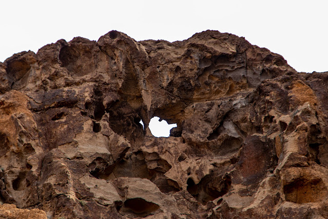
Mile 10.5:
You will reach
a junction with a clear sign directing to Hole-in-the-Wall, here you need to
turn right. If you will keep driving straight you can reach Camp Rock Spring.
After turning right,
you will climb out of the lower section into the upper open plateau.
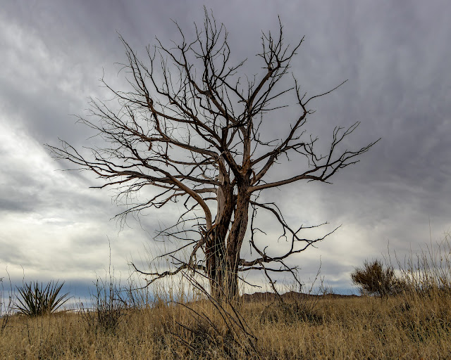
Keep driving until
seeing a secluded farmhouse on your left.
This section
was burned at 2005 fire so there are many dead tress skeletons.

Mile 13.47:
You will reach
a trail junction with a clear sign. Turning right will lead you to Mid Hills
Campground.
If you are not planning
to stay in the campground for the night or you do not drive 4x4 car there is
not so much point to turn right, keep driving additional 7 miles on the main
road straight to Hole-in-the-Wall, overall, this will be 21 miles drive from
the starting point.
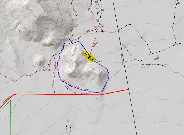
If you do have
4x4 car than I will recommend doing this out of the main road loop and not
drive directly on the main road to Hole-in-the-Wall.
Mile 15.5:
This is the
entrance to the Mid Hills Campground, from this point onward the road is restricted
to 4x4 drive car.
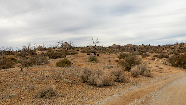
Mid Hills Campground:
A Fire swept
through the area in 2005, burning much of the vegetation, most tress around the
camp are dead. The unburned section is located at the back of Mid Hills
Campground.
There are 26
campsites and last time I visit here (Jan 2022) they are all in excellent condition.
At 5,600 feet
in elevation, Mid Hills is much cooler than the desert floor below. The access
road is unpaved and is not recommended for motorhomes or trailers.
There are pit
toilets, fire rings, picnic tables in every campsite.
Mid Hills
Campground has no water!
Fees: $12 per
site per night.

The below
description is relevant to the 4x4 road section:
Mile 15.5:
Keep driving straight
into the 4x4 road.
From this point
the road is heading down gradually from the ridge top into the river bad.
The road is
mostly in good conditions and not real 4x4 capabilities are needed, although high
clearance is always good.
Keep driving on
Wild Horse Canyon Road.

Mile 20.1:
Here you will
get into trail junction, keep driving straight on the main road and do not turn
right.
You will cross several
dry riverbeds, overall, the road was in good condition without any navigation or
driving challenges.

Mile 26:
Here you will
reach the end of the dirt road drive and re-connect to a paved road.
Turn left and
soon you will see the entrance to Hole-in-the-Wall visitor center on your left.
www:
https://www.nps.gov/moja/index.htm
Map:
https://www.nps.gov/moja/planyourvisit/upload/mojamap1.pdf
Pictures:


Comments
Post a Comment