
Introduction:
What? : This blog describe
the one hour, 13 miles 4x4 offroad drive from Essex Road (Hall-in-the-Wall) to Kelso Dunes.
Related blogs:
Mojave National Preserve – Hole-in-the-Wall
Mojave National Preserve – Kelso Dunes
Mojave National Preserve – visit planning, 2 days trip itinerary
Mojave National Preserve – Visit Planning

Where? : My off-road
drive starting point was at the junction of Essex Rd., and Black Canyon Rd.
Google Map Link

When? : Late fall, winter
and spring is the preferred time to visit the Mojave desert, summer is just too
hot.
Due note 1: Water - Always take
more than what you think you need, this is desert and temperature can be hot,
in summer this is extremely hot environment.
Due note 2: This road cannot be
done by regular car!
In some places high clearance,
good tires and 4x4 drive is needed, not recommended for AWD.
Due note 3: Few notes about off-road
driving:
For any long off-road
driving activity, you must plan a head and know what you are doing!
Understand you’re
driving abilities and your car limitations and analyze the driving conditions
all the time. Think what if I need to turn around, can I make it back out.
Do not think “if
I can pass it?” but rather “what I will do if I get stack?”.
Things can “just”
happen, you may have flat tire or other car malfunction, you can get stack in “simple”
to pass places, in mud, deep send or river bad, the road can be un-passable, or
you may even lose your way in the desert.
It is not about
pride, if the road gets too rough for you, turn around!
In the event of
an emergency, for un-trained people, staying with your car is probably the most
important thing you can do.
Make sure you
have a proper map and that you know how to navigate.
Know how to use
your gear, change flat tire or how to drive in deep send or mud conditions.
Garmin
satellite phone is always good to have with you for emergency and map.
Make sure you
have a basic Firs-Aid kit and that you do know how to use it.
Do not travel
cross-country or create new routes. This rule is strictly enforced; violators
will receive citations. Driving in washes is not permitted.
In Mojave
National Preserve, Groups of more than 7 vehicles or 25+ people require a
Special Use Permit.
Important Notice: ATVs and UTVs
Not Permitted in Mojave National Preserve at all!
Due note 4: Drive with enough
fuel, no gas station in Mojave National Preserve
Due note 5: No cellular reception
in Mojave National Preserve (you may have receptions near the main Highways). If
you are using cellular map with GPS make sure you download the map in advance
where you have cell reception (Wi-Fi connectivity is preferred).
Due note 6: During winter
month, bring with you few warm cloths, you may get warm during the day and the hike,
but you will need them once the sun is going down in a cold evening.
My thoughts: Moderate difficulty
to drive dirt-road. Simple to navigate, just drive straight to the mountain
pass and from there to the dune’s valley below. I had fun and save me the long 50
miles road drive.

The Drive:
After visiting
Hall-in-the-Wall I headed to Kelso Dunes. For that I need to drive the main
road south to I-40, drive west and get back into Mojave National Preserve on for
Kelbaker Rd (exit 78), drive additional 15 miles and then get to Kelso-Dune’s
trailhead, this is a 50 miles long drive (one hour).
Looking at the
map I saw 13 miles off-road trail that is crossing the mountain range with a straight-line,
following high voltage electricity line, all the way to the dunes area.
I decided to
drive it, maybe it will take the same amount of time as the paved road loop will
take me but for sure I will have a lot more fun.

I did not have
any information about the road conditions, even if you read something on the web
a recent rainstorm can change the road conditions.
I do have many
years of off-road experience but because I’m driving alone, it is only me and
my car, I need to careful not to get stack. I told myself that if I encounter
real challenging to cross section I will drive back and take the longer paved road
drive.
Although it is
only 13 miles it took me almost an hour to drive, the section that climb the
mountain pass is rocky, and I tried to avoid getting flat tire.
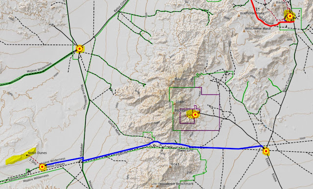
The drive starts
at the junction of Essex Rd., and Black Canyon Rd.
There is a
trail that start exactly at the junction (I think it follow an underground gas-pipe),
but I went 0.4-mile north on Essex Rd. until I saw the power line and a clear
road to my left.
I turn left and
start to drive straight toward the mountain pass at the horizon.
After 1.7 mile
the power line road connect to the underground gas pipe road.
The first 3
miles of the drive are easy, and you are crossing many dry riverbeds.
The road start
to climb and the river gravel and send changed into rocks, still no problem
with passing any obstacles.
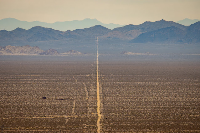
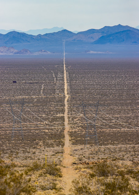
Looking back
from here and you can see the dirt-road and the power line stretched all the way back
for at list 20 miles of straight line in the valley below.
The road start
to climb moderately but constantly, after 6 miles you start to get into a narrower
section and the road start to climb the mountain ridge. No “drama” or major obstacle,
soon you will find yourself on the ridge line crossing over to the west.
This point called
Foshay mountain Pass, this is 7 miles from the starting point.
From here you
can see the road continue straight west into Kelso Dunes basin.


Start driving
down and after 1 miles (8 miles from your starting point), you will see a trail
to your right, keep left (straight) on the main road.
From here the
road cross many dry river creeks, although overall descending you will go done
to a creek and climb up on the other side.
Taking this
road east to west, as I did, is much easier than the opposite directions, angles
are steeper going done and less challenging when going up. Good driver with 4x4
high clearance car can drive it west to east.

I did not have
any issues with passing obstacles or even use 4x4 low, just good driving skills
and some momentum overcome any climb.
After 13.2
miles from my starting point, I reach back to a paved road.
Here turning left
will take you to I-40 (38 miles), turning right will take you to Kelso Dunes (0.25
miles to the turn left junctions) and to Kelso Depot (8 miles drive).
I turn right
and headed to Kelso Dunes parking lot and trailhead
It was a fun
drive with a nice desert view, overall, not difficult but heavy rains can damage
the road, especially at the river & creek crossings.
www:
https://www.nps.gov/moja/index.htm
Map:
https://www.nps.gov/moja/planyourvisit/upload/mojamap1.pdf
Pictures:


thnks
ReplyDeleteIssues are never anyone’s choice, but shockingly hundreds of issues can happen anytime with anyone. These issues may moreover incorporate car mishaps, sudden breakdowns, and numerous others. In such cases, like mishaps and breakdowns, individuals require the assistance of Coquitlam Towing Service.
ReplyDelete