
Introduction:
What? : Cloud Rest is probably
one of Yosemite's best 360-degree panoramic views in the park and as a bonus, a
unique, from above, view of Half Dome.
There are few
trails that reach this mountain top location, and, in this blog, I will describe
the “easiest” and shortest popular option, Starting from Tenaya Lake in Tioga
Pass.
This is 13
miles out and back with 3,100 ft elevation gain where the mountain top is at elevation
of 9,926 feet (3025m).
I consider this
trail to be a strenuous hike !
Include 30
minutes rest at the top it took me total of 5:45 hours. I’m relatively fast hiker
(av 3 miles/hr) please plan at list 7-8 hours for more relax hiking.


For a Beautiful Nature Prints - Visit my Etsy Store
Where? : The trailhead is
located just before reaching Tenaya Lake, it name in google map is “Sunrise
Lakes Trailhead”. You will see the large parking lot on your way down from Olmsted
Point.
Google Map Link


When? : You can do
this hike only when Tioga Pass road is open to traffic. Usually, it is open late
May to mid Nov.
Even if the
road is open the trail may be covered with snow into the season so check snow
and ice conditions in advance.
I do not recommend
to hike this when the mountain is covered with snow. Another thing you need to consider
are clouds that can hide the view completely.
See Tioga road
conditions at:
https://www.nps.gov/yose/planyourvisit/tiogaopen.htm


Additional Yosemite and nearby locations blogs:
Yosemite National Park – How to plan your One-Day visit
Yosemite NP – Tioga Pass Road
Yosemite NP – Tioga Pass May Lake Hike
Yosemite NP – Tioga Pass North Dome Hike
Yosemite NP – Tioga Pass Lembert Dome Hike
Yosemite NP – Tioga Pass Tuolumne Meadows
Yosemite NP – Tioga Pass Tenaya Lake
Yosemite NP – Hetch Hetchy Visit Planning
Yosemite NP – Hetch Hetchy, Wapama Falls Day Hike
Yosemite NP – Hetch Hetchy, Laurel Lake Day Hike


Due note 1: Plan for 7-8
hours of hiking, make sure you have enough daylight time, it is not fun to hike
here after dark, at summertime when it is hot start early for more cool temperatures
hiking.
Due note 2: there are
plenty of water sources along the hike, so you do not need to carry a lot of
water with you. Make sure that you have purification filter system with you and
do not drink water without it. Bring with you light trail snacks or your
preferable trail food for the day.
Due note 3: Check weather
conditions at the park website before you are heading up the trail, this is high
exposed area and weather can change fast (especially later fall), bring proper
clothing with you.
Due note 4: This is
relatively popular hike so do not expect to be the only one here, but this is
not overcrowded, and the top of the mountain is relatively flat with plenty of
room to all hikes.

Due note 5: You may have
problem to find a parking spot at the trailhead, keep driving and immediately get
into the second parking lot near the lake, the trail is connecting the 2
parking lots.
Due note 6: You can find
toilet and food bear locker at the trailhead parking lot.
Due note 7: You may see Black
Bears in Yosemite, but they really be dangerous or aggressive, Bear Spray is illegal
to carry in Yosemite (and in California).
Due note 8: No permit is
needed for day hike Clouds Rest trail.
Due note 9: You may here
that this is a dangerous hike with narrow path over cliffs. This is not correct!
Yes, the top of
Clouds Rest is relatively narrow rocky exposed ridge where there are on both
sides sheer hundreds of feet drop-off but safely wide (10’s ft) and if you are
not intentionally walking to the edge there is no danger of falling. This is
much wider compared to Angels Landing trail in Zion NP and a lot less steep trail
compared to the Half Dome cable route.


Due note 10: Be careful when
you are taking your pictures and selfies on the edge of the cliff, especially
when there is a strong wind blow.
Due note 11: If there are
thunderstorms, it’s not safe to be in in the exposed mountain top.
Due note 12: In clear sky
sunny days sunscreen is highly recommended.
Due note 13: In early summer
bring mosquitoes repellent with you.
Due note 14: Tioga Road does
not have cellphone coverage, but you may have a cell phone reception at the
mountain top (there is an antenna at Glacier point).
Due note 15: Dogs are not
allowed on most trails in Yosemite National Park.
Due note 16: The Tuolumne
Meadows Grill & Store is closed.
Due note 17: At my last
visit during Dec. 2022, they were finally near the finish of Tioga Pass Road renovation.
This improves the road and driving conditions but reduce the numbers of available
parking spots on the roadside.
Due note 18: For the most experience
and in shape hikers you can hike to Cloud Rest from Yosemite Valley. You will
start at Happy Isles trailhead (the main Half Dome trailhead). It's a 20 miles round
trip from the valley floor with almost 6,000 feet of elevation gain so know what
you are doing and come prepared for the challenge.

My thoughts: No doubt this
is strenuous day hike but one of the most rewording I did in the park. Although
it is not extra-long trail (13 miles in total) there is a lot of uphill climbing,
and you start from a relatively high altitude; you need to sweat before you can
enjoy the view.
I was here
several years ago as part of a few days’ backpacking hike in the park. At that
time (late fall) there were a lot of wildfires not so far that covered the
mountains with smoke, the view was rewording but covered with smoke, this time
after the first rain and snow the sky where clear and the weather was perfect.
I did this Hike
as a one-day trip from San Francisco Bay area, start to drive at 5:30am, reach
the trailhead parking lot after 4 hours and start to hike at 9am. After the 6
hours hike, I went and hike in Tuolumne Meadows and only then I drove back home,
arriving home at 9pm. Very long but rewarding day.


The Hike:
Like most other
main trails in Yosemite NP this is also well-maintained and to navigate trail, “just”,
walk, follow the signs and you will be in Cloud Rest in 3 hours or less.
You will start
your hike from the parking lot and immediately after crossing the short wooden
deck you will need to cross Tenaya Lake river.

By mid-summer you can usually cross it without wetting your shoes, and by late summer it will probably be dried., In the spring, when the snows are melting, you'll have to cross it in the water. Usually, the current is not strong, and you can use the rocks and hiking pools for stabilize yourself.

For the first
1.4 miles the trail climbs moderately, slightly turning to the left into the
ridge and away from Tenaya gorge. From here you will start the first climb of
your hike, in 1.2 miles you will climb 1,000 ft of elevation. In this steep section
the rocky trail zigzags the mountain in a constant climb.


At the top of
your climb, you will reach a trail junction, turning left here will lead you to
sunrise lake and Sunrise High Sierra Camp, you need to keep walking straight and
start to hike down on the other side of the ridge.

In this
relatively exposed section, the trail descending steeply at first and later it
leveled. From the trail junction you will walk for 1.1 miles until you will see
a small pound on your right.


After the lake
the trail start to climb moderately for another 1.1 mile. Here you will see high
above your left side Sunrise Mountain peak, do not worry, the trail is not climbing
this mountains 😊.

Keep walking in
straight direction and after additional climbing in the forest you will reach
another trail junction, you need to turn to the right, from this point to the
top is another 2.6 miles.
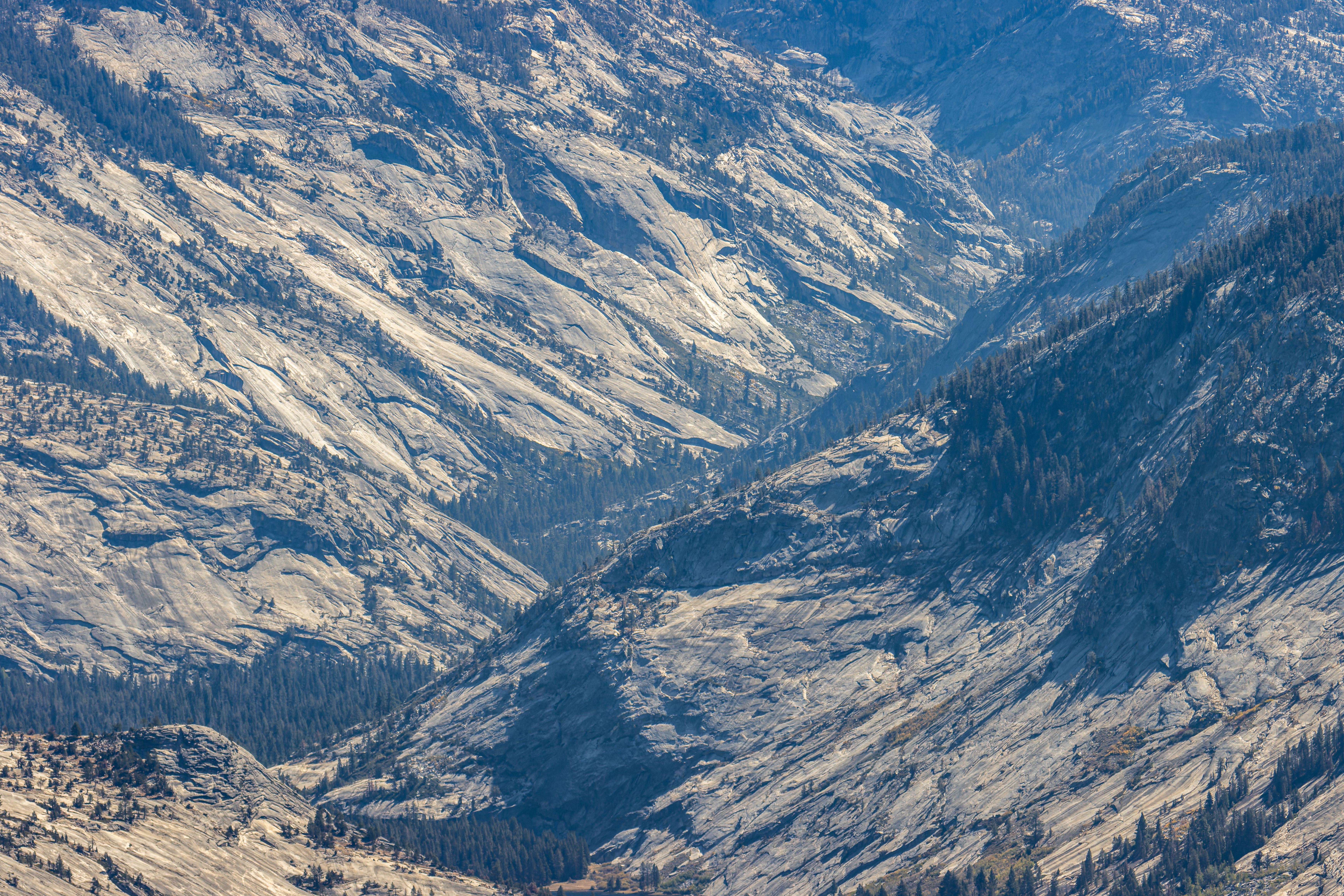
The landscape change into more open old forest, and the trail start to climb. Here you will start to see the view to your left, the huge deep canyon of the Merced River that flow into Yosemite Valley.


At some point you will be able to see your
destination between the trees to your left.

The trail climbs
and once you are getting out of the tree line into the exposed rock you know
you are getting closer to your destination.


This is
probably the most challenging section of the hike. The trail finds it way over
the rock and at some point, it starts to walk where you can see the view from both
sides.
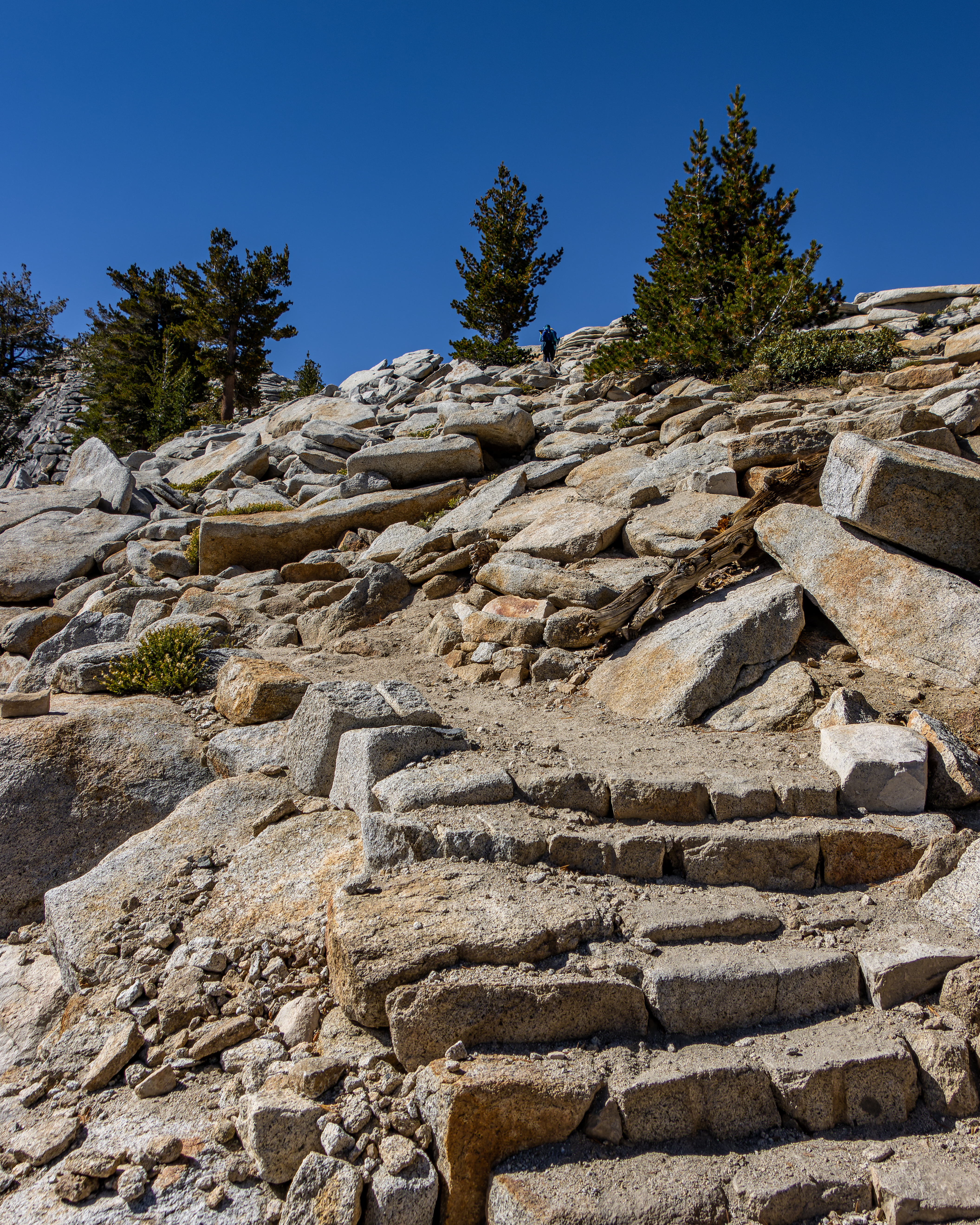


Here you will
have few relatively narrow sections to cross, keep heading straight up while
taking the left side of the spine, away from the right-side cliff. You will
cross few rocks and once you will approach the summit it gets less steep and
wider.
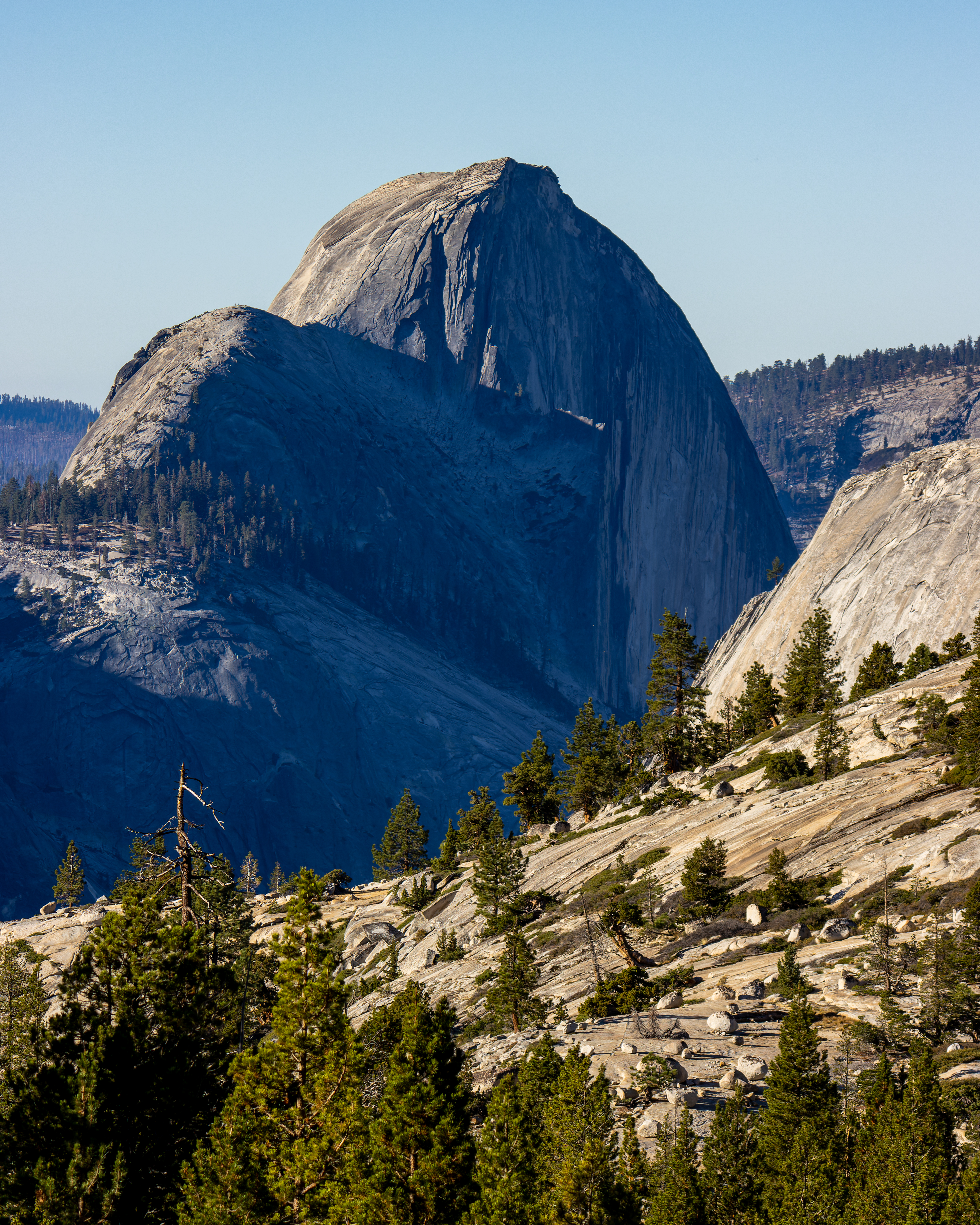
After 6.5 miles
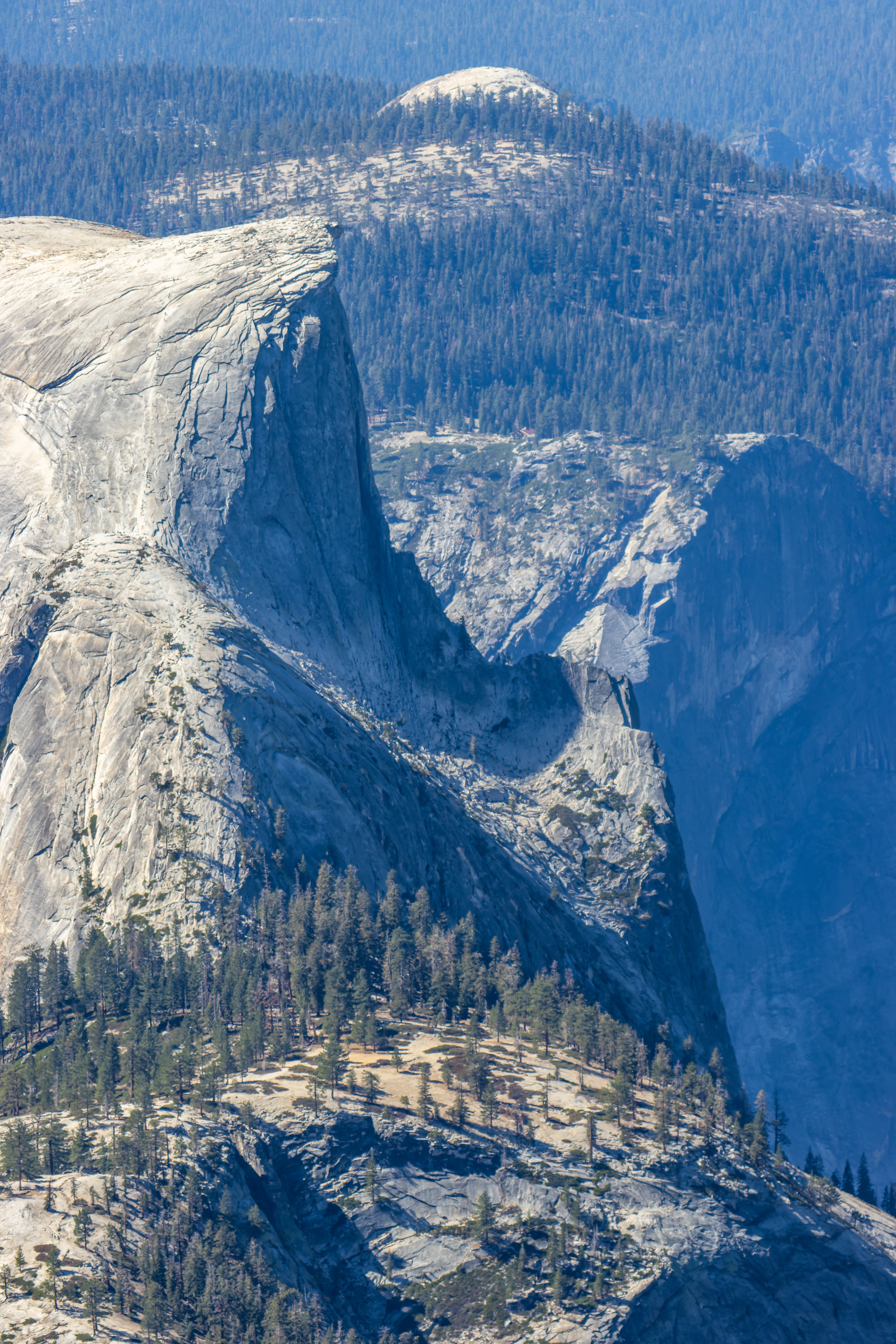
from your starting point, you will reach the top of Cloud Rest, walk to the
west side of the high point and only from here you can see Half Dome over 1,000
feet below you.
Take a rest and
enjoy the amazing 360-degree landscape in every direction.
If you have
with you a binocular or a camera with a good zoom (I carry my 1500-600 mm zoom)
you can see the Half Dome cable line and people climbing it.


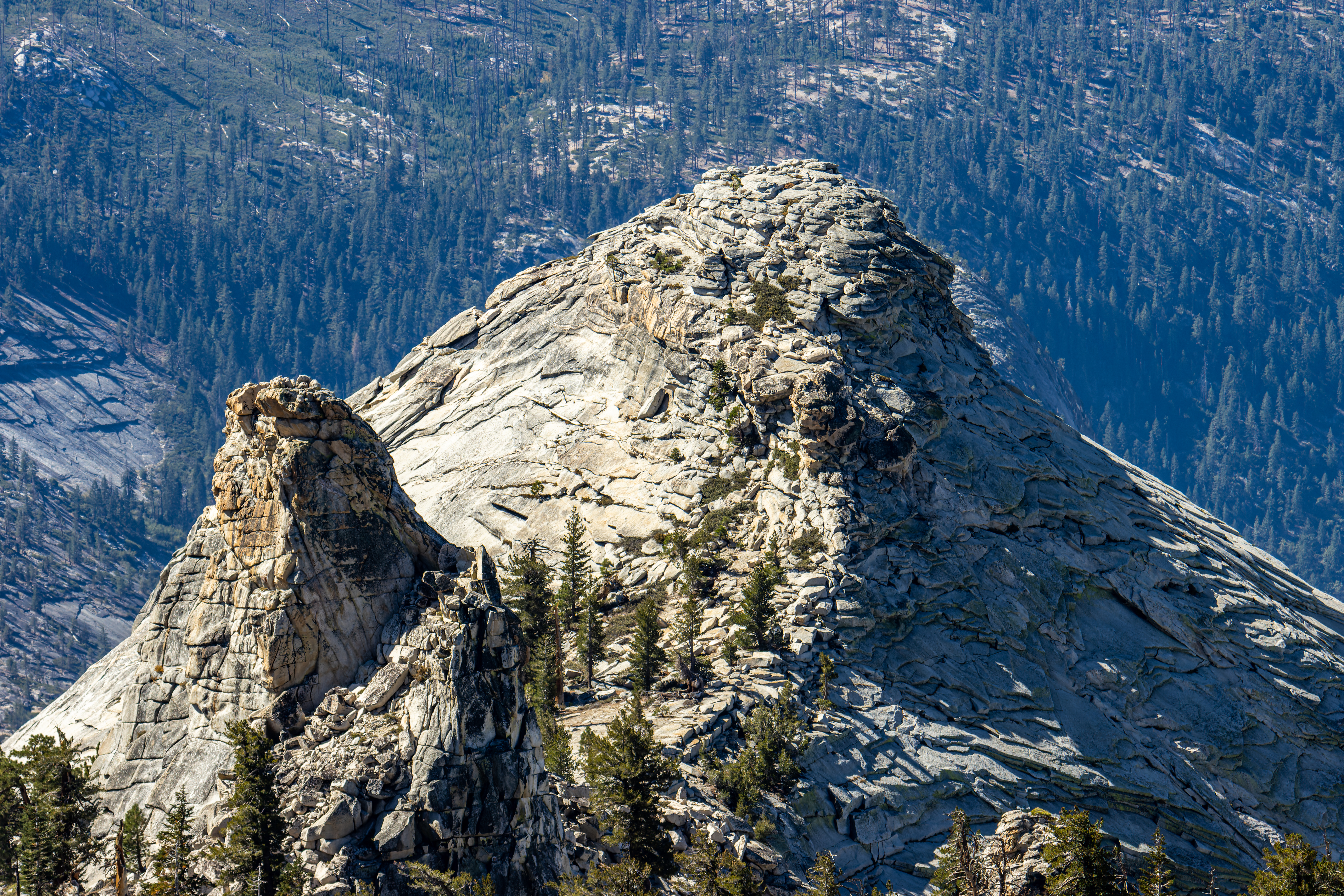
Take your time
to identify many of Yosemite famous landmarks.
Infront (southwest)
you can see Half Dome and below Yosemite Valley, far away on both sides you can
see El Capitan on the right and Cathedral Rocks East on the left.

Turning clockwise you can see North Dome below you, on the direction you can from you can see towering Mt Hoffmann and Olmsted Point, Tenaya Lake.


Keep turning and you will see all
the mountains that are surrounding the deep long canyon of the Merced River … Johnson
Peak, Vogelsang Peak, Mt Florence, Mt Clark, and Mt Starr King…

If you look carefully
at straight line below Half Dome face cliff you can see on the mountain above
Yosemite Valley Glacier Point, large house and viewing deck.

It can be windy
here so if you are getting cold do not hang here too long.
Now you need to
walk back the same way you hiked too here.
Except one
steep climb after the pound this is mainly downhill or flat trail so you will
walk much faster on the way back.

Pictures:


Comments
Post a Comment