
Introduction:
What? :
This is
15 miles out and back hike, the trail introduces major climbing on the way up
with elevation gain of 3,484 feet, plan for at least 8-9 hours hike.
This day hike
is not for everyone, but you will be reworded by the amazing view of Hetch
Hetchy lake from above, wilderness forest hike, and remote lake at the end of
the trail. The bonus is that on your way back it is all one long downhill 😊


Where? : Located in Hetch
Hetchy section of Yosemite National Park.
Google Map Link


Additional Yosemite and nearby locations blogs:
Yosemite National Park – How to plan your One-Day visit
Yosemite NP – Tioga Pass Road
Yosemite NP – Tioga Pass May Lake Hike
Yosemite NP – Tioga Pass North Dome Hike
Yosemite NP – Tioga Pass Lembert Dome Hike
Yosemite NP – Tioga Pass Tuolumne Meadows
Yosemite NP – Tioga Pass Tenaya Lake
Yosemite NP – Hetch Hetchy Visit Planning
Yosemite NP – Hetch Hetchy, Wapama Falls Day Hike

When? :
The best time
to visit here is at spring when the waterfall are flowing with water.
Summer can be
relatively hot (due to the relatively low elevation), at late fall when upper
sections of the park are close to access this area of the park is still open
because the snow comes late here.
One year with
almost no snowfall I hiked here early January, some snow sections at the high
sections of the trail but other than that it was clear.


At winter month
after major snow storm the road down to Hetch Hetchy is closed.
Check at the
park website for exact road conditions and road closer:
https://www.nps.gov/yose/planyourvisit/conditions.htm
Note: last time I was
here was in 2019
Due note 1: This road has
seasonal hours corresponding roughly with daylight hours; during summer 2022
the road will be open from 8 am to 5 pm.
See website for
up-to-date information:
https://www.nps.gov/yose/planyourvisit/conditions.htm
https://www.nps.gov/yose/planyourvisit/hh.htm

Due note 2: Dogs and other
pets are prohibited on all trails and on the dam. Dogs are only allowed in the
parking area, and they must be always leashed.
Due note 3: There is no
service or visitor center in this section of the park.
Due note 4: Swimming and
boating are prohibited in Hetch Hetchy Reservoir
Due note 5: There are
restrooms at the upper parking lot.
Due note 6: this trail is less
crowded compared to the trail to the falls along the lake.
Due note 7: You can also
hike to this small lake from Lake Eleanor (remote lake located outside of
Yosemite National Park), it’s an 8.2-mile hike, one way, with a climb of 1,800
feet.
I never visit Lake
Eleanor so I can’t provide more information about this hiking option.

My thoughts:
I visit here two
time, one as a day hike up and down early winter and the other time as part of
multi day hike deep into the north wilderness.
This is strenuous
hike, and the climb can be brutal. You think that you reach the top after the
switchback but than you are getting into another steep climb. The upper
sections with all the meadows and wetlands are rewording.
On your way
back you can enjoy the amazing view of the lake below.
Few general hiking guidelines:
Stay on
established trails, pack out what you pack in, Overnight backpackers need a
wilderness permit, carry (and drink) plenty of water. Be sure to treat river,
stream, lake, or spring water.

Gas Stations:
The nearest gas
station is located on highway 120, 4.4 miles east of the junction of highway
120 with Evergreen rd.
There is
another gas station inside the Yosemite Park highway 120, 7.8 miles east of the
park entrance.
Nearby Hotels:
At the small
place called Mather you can find few hotels (Evergreen Lodge cabins or Rush
Creek Lodge) and lodges and here you can also find small General Store to buy
food.
There is the
new lodge on highway 120 and Evergreen: Rush Creek Lodge and Spa at Yosemite
You can also
find many hotels and restaurants at the small town of Groveland.


Driving directions:
Hetch Hetchy is
part of Yosemite National Park, but the entrance is separate from the rest of
the park roads.
Coming on highway 120 from the
West:
A half an hour’s
drive east from Groveland via Highway 120 you will reach a clearly mark exit to
your left into Evergreen Road (just after the new “Rush Creek Lodge and Spa at
Yosemite” and just before getting into Yosemite NP north entrance).
You will drive
down on all the way until you will reach a T junction at. Here turn right onto Hetch
Hetchy Rd. and after 2.6 miles you will entering Yosemite National Park pay
station. Drive slowly the next 8 miles where the road plunging into the deep
canyon of the Tuolumne River, from some viewing point along the road you can
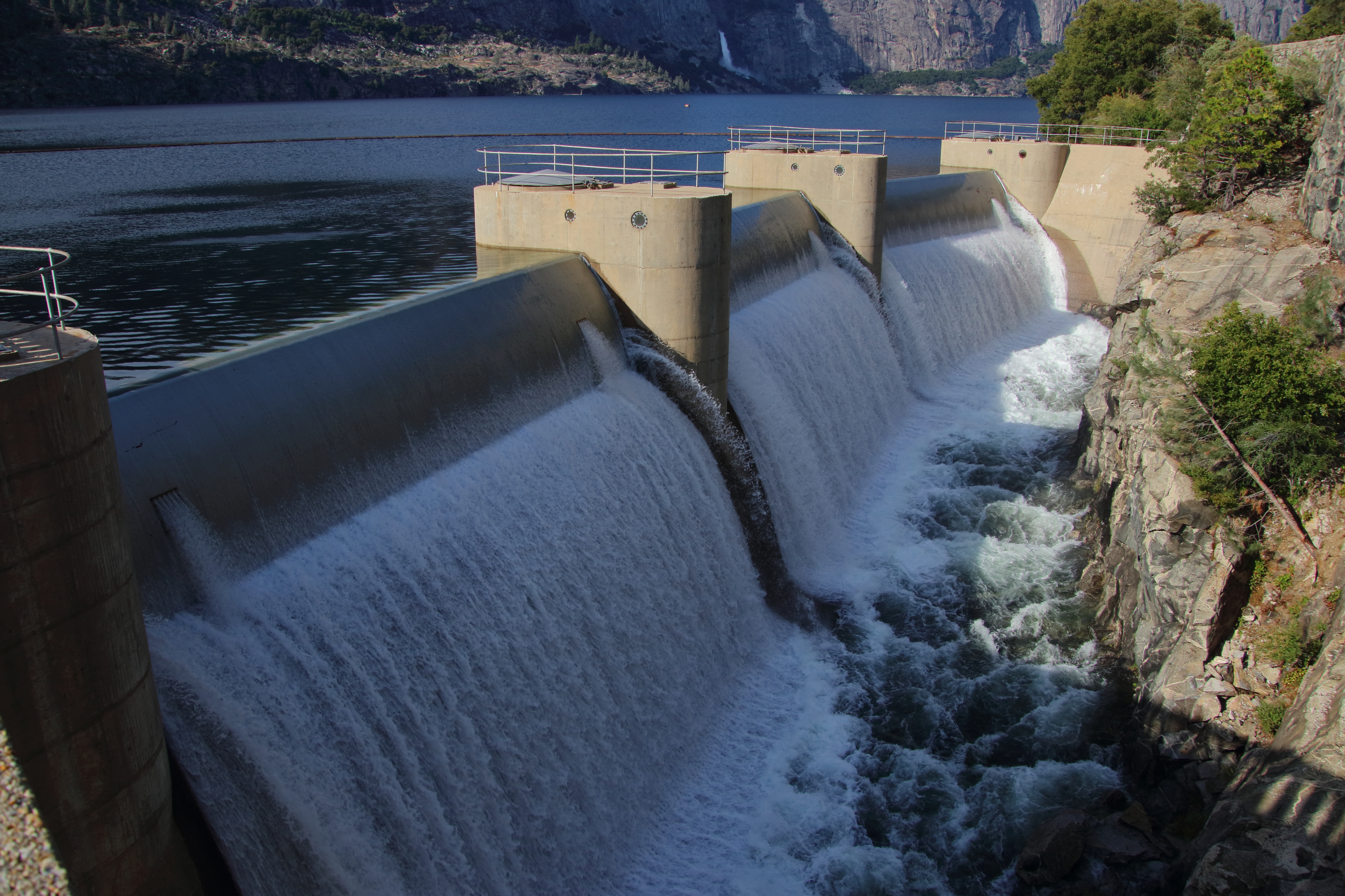
see far below you the impressive O’Shaughnessy Dam concrete structure.
Coming on highway 120 from
Yosemite National Park:
Pass and exit
the Yosemite Park north entrance and after a short 1.2 mile drive you will see
a clear turn to your right.
Follow the
above instructions to Yosemite Hetch Hetchy section.

Parking:
Near the end of
the road, you will drive into one lane section, pass the building on your right,
and drive down to the dam, here you will find plenty of parking spots along the
right side of the road. If there aren’t any available parking spots here, you
need follow the loop back up and find parking at the junction or at the backpacking
parking lot.

The Hike:
To get a
bird’s-eye view and a heart-rate spike, climb the steep switchbacks up Beehive
Meadow Trail, with its edges lined with vivid floral displays.

Laurel Lake and Another popular trail crosses the O’Shaughnessy Dam.


Walk in the direction of Wapama Falls and after 1 mile from the dam you will see clear sign mark the trail up (left).
Take a left
turn to climb steeply out of the Hetch Hetchy valley.

In this section
the trail follows an old construction road that connects the Dam construction
site to upper Lake Eleanor, Miguel Meadows Fire Road. The trail is wide and in
relatively good shape.
Each switchback
reveals scenic overlooks of the reservoir and Kolana Rock, stop for relaxing
your breath and enjoy the changing view below you.


The trail
continues to climb for 1.8 miles above the trail intersection, but you can turn
around any time.
After completing
9 large switchbacks and hiking 2.9 miles from the starting point you will get
into the forest, and you will reach trail junction.

The trail to
the left will take you to Lake Eleanor, here you will separate from the wide
trail (Miguel Meadows Fire Road), take right here, and continue climbing up the
narrow trail.
This section of
the trail turning to the right in the forest, and then left up.
Keep climbing until
you will reach, after 4.7 miles, a flat section. Here you start the open meadowy
section of the hike where the trail cross forest patches damage from the 2013
Rim Fire.


The trail crosses
the flat section that have few pools, at early season lots of the paths getting
to the lake can be partly flooded or muddy.

After 5.3 miles
from the TH you will see a trail connecting from your left, keep walking until you
will see the sign left to Laurel Lake (6.1 miles from TH).

Turn left and
after crossing a local stream and total of 1.2 mile you will reach the lake.
Here you can
rest and enjoy the quiete lake.

Once you are
done you need to hike back the 7.3 miles you climb, this time almost the entire
hike is waking down.
If you’re planning
a longer hike and overnight backpacking trip, you can continue to Lake Vernon. You
can make it a loop hike going back down from Rancheria Falls.
www:
https://www.nps.gov/yose/planyourvisit/hh.htm
Map:
https://www.nps.gov/yose/planyourvisit/upload/hetchhetchy-sitebull.pdf
Additional Pictures:


Comments
Post a Comment