
Introduction:
What? : At elevation of
8,600 feet above sea level, nearly two miles long, with the Tuolumne river
winding gently through it and a variety of picturesque granite peaks and domes
surrounding it the Tuolumne Meadows is one of Yosemite gems and most visited
destination. You will drive here through Tioga pass that is a destination by itself
and provides many viewing spots, hiking trailheads as well as providing access
to Yosemite Park from the east.


For a Beautiful Nature Prints - Visit my Etsy Store
Where? : located at the
park high elevation nested within the Sierra Nevada mountain range.
Located on
Tioga pass, highway 120.
The meadow is located
8.3 miles from the east park entrance (20 miles from highway 395), and 38 miles
from the junction with Big Oak Flat Rd.
If you are starting
your drive from Yosemite Valley than you first need to drive 16 miles north on Big
Oak Flat Rd and then you need to turn right (near the gas station) and drive
the additional 38 miles to the meadows. With few short stops to enjoy the view,
plan for at least 1.5-hour drive from the valley to the meadows.
Google Map Link

Additional Yosemite and nearby locations blogs:
Yosemite National Park – How to plan your One-Day visit
Yosemite NP – Tioga Pass Road
Yosemite NP – Tioga Pass May Lake Hike
Yosemite NP – Tioga Pass North Dome Hike
Yosemite NP – Tioga Pass Lembert Dome Hike
Yosemite NP – Tioga Pass Tenaya Lake
Yosemite NP – Hetch Hetchy Visit Planning
Yosemite NP – Hetch Hetchy, Wapama Falls Day Hike
Yosemite NP – Hetch Hetchy, Laurel Lake Day Hike
When? : If you are
planning to drive Tioga pass road (highway 120), enter or exit the park east
entrance or visit Tuolumne Meadows make sure to visit the park main page to
understand if this road is open or close. The road is usually open from mid-May
to end of October.
Follow the link
below for history records of road opening and closing dates:
https://www.nps.gov/yose/planyourvisit/seasonal.htm
The recommended
time is at spring when the road is open, all is green and the mountains top
covered with snow.
Summer and fall
are also good time to be here because it is not hot at the higher elevation. At
fall the river is running low and the grassland is yellow.

Due note 1: Interesting to
know that Tioga Pass (highway 120) that cross the Sierra east-west mark the
north section of the largest contiguous roadless wilderness in the continental
United States. From this road all the way 150 miles to the south of Mt. Whitney
(highway 178), no other roads cross the High Sierra.
Due note 2: Tuolumne
Meadows is the largest high-elevation meadows in the Sierra Nevada and probably
also the most accessible one, Tioga pass road (highway 120) cross it east to
west and there are many parking spots along the road.
Due note 3: Tioga Pass
Road went under renovation so driving conditions are good.
Parking: The main problem is that during crowded weekends
and holidays it will be challenging to find parking spots at specific location
along the road, plan to be flexible.
After the road face-lift
the number of road shoulders parking spots has reduced, there are still many locations,
but they can be occupied. There are few large parking lots along the center
section of the valley.

Due note 4: The nearest
Gas stations locations:
West: 38 miles
at the junction with Big Oak Flat Rd.
East: 21 miles at
highway 395 and the town of Lee Vining
Due note 5: Restrooms can
be found at the visitor information center and near large parking lots along
the way.
Due note 6: when I visit
here, Oct. 2022 the grill & convenience store near the east end of the
meadow was close and under major renovation. Not clear when this will be open.
Due note 7: There is a
large campground in Tuolumne Meadows but from my experience it is fully booked
early in the year. If you are planning to stay here, book your campground in
advance.
Due note 8: Bring mosquito
repellent with you if you are visiting here at spring or early summer.
My thoughts: The view of
the large high meadow from a roadside parking is very nice but to really enjoy
it you need to walk into the meadows. The Tuolumne River flowing gently,
winding through the grassland, and the view from the “far” side of the valley
to the east is much more impressive, where ragged mountain peaks towering into
the sky.
The hikes here
are relatively shorts and easy and fun to do.

The Visit:
The Tuolumne Meadow,
is nearly two miles long, is fun and rewarding place to visit. This is not
about the long hikes to mountain peak but rather the easy-going vibe of the river
winding through the grassland and picturesque granite peaks surrounding it.

For three miles
the Tuolumne River runs through the middle of the meadows and in spring as soon
as the snow melts it flooded and practically transformed into a shallow lake. Tuolumne
River is flowing and creating the remote but amazing Grand Canyon of Yosemite
and eventually foe into Hetch Hetchy Reservoir (the man-made lake has a huge
dam in it west end, this is the source of San Francisco).
Trailheads and Parking:
There are three trailheads’
entrances to Tuolumne Meadows:
1. From
the western side of the valley, near Pothole Dome.
2. The
middle one is located near Tuolumne Meadows Visitor Center (there are two large
parking lots nearby).
3. Eastern
edge, at the Dog Lake/Lembert Dome trailhead.
In the peak tourist
season Lembert Dome Parking lot gets filled up early in the day. so be prepared
to look for parking in nearby areas and roadsides. Park off the road, do not
block any side roads, and obey any "no parking" signs. You can also
park at the wildernesses center east of here.
Few general hiking guidelines:
Stay on
established trails, pack out what you pack in, Overnight backpackers need a
wilderness permit, carry (and drink) plenty of water. Be sure to treat river,
stream, lake, or spring water.


Hiking Options:
Tuolumne
Meadows has few relatively easy hikes that cover the main meadows.
You can also
hike from here into the mountains or nearby valleys.

Valley Walk:
This is
probably the easiest, shortest, and maybe the most rewarding hike in the meadows.
You can do this
as 1 mile out and back or 3 miles loop hike.

You can start
this hike from the Visitor Center or at the Dog Lake/Lembert Dome trailhead.
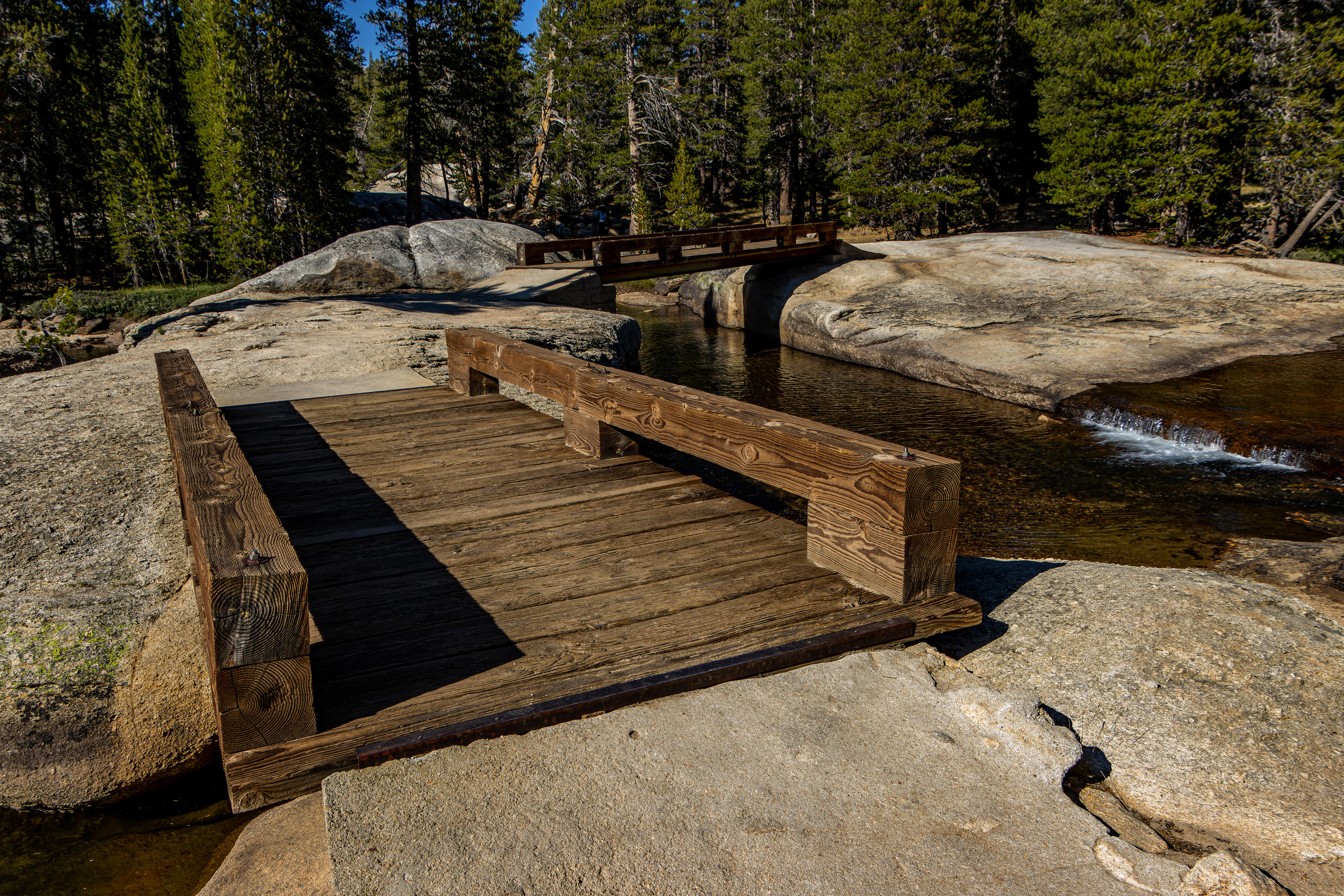
Start from the visitor center and carefully cross the road into the meadows, here you will be walking on a wide flat trail. Soon on your right you will see the Tuolumne River, keep walking and after 0.4 mile you will reach the large wooden picturesque bridge.


Here
you can enjoy the view of the river below. Now is the perfect time to look
back, you will see the panoramic view of the high granite domes and peaks of
the mountains above the road.

Fairview Dome, Cathedral,
Echo, Cockscomb and Johnson Peaks are the most dominate peak and the
entire high mountain range contrast the flat meadows below and frame it wonderfully.
From the bridge turn left and then right and walk to the nearby Parsons Memorial Lodge.

From here
see Soda Springs (do not expect too much, this is nothing more except few bubbling
water outlets).


Here you have
few options.
You can walk west
on a dirt road parallel to the river, this is a short ¼ mile long walk, you
need to go back to the bridge, or you can walk back to your car.

Another longer
option is to walk east to the direction of Lembert Dome trailhead. If you
decided to go to Lembert Dome trailhead you will need to go back the same way
you came or walk parallel to the Tioga Pass Road (there is a pedestrian trail near
the road).
Lembert Dome Hike:
Lembert Dome is one of the most impressive large granite mountains that is rising 800 feet above the eastern edge of the Tuolumne Meadows, just above the Tioga Road.


This
3.7-mile loop trail features stunning panoramic views looking west across
Tuolumne Meadows. Plan for 3 hours to enjoy this hike.
Although the trail
involves some climbing and exposed rock section the Lembert Dome Trail is one
of the least strenuous ways to enjoy the panoramic view of this area of the
park.
For detailed
hike blog follow this link: Lembert Dome Hike

Upper Tuolumne River Valley:
Another option
for easy going, hike without any climbing and we a nice river & meadows
views is along the Lyell canyon, the main contributor of the Tuolumne River. You
can start your hike at Lembert Dome trailhead or drive east on Tioga Road for 0.6
miles, turn right into Tuolumne Meadows Wilderness Center, and follow the road
to Rafferty Creek Trailhead.

I will describe
the hike starting at Lembert Dome trailhead:
From the
parking lot walk across Tioga Road and look for the PCT trail. Hike east and
after passing the Wilderness Center you will arrive to Rafferty Creek Trailhead,
0.8 miles from your starting point. Here the trail turns right following Dana
Fork. After a short walk you will arrive to abridge that cross the creek.
You will walk
south in a nice large pines forest and after 0.6 miles you will reach a trail
junction, the PCT turn here left and you need to decide what you want to do; You
can turn left and walk some more on the PCT until you had enough, and you will
turn around or you turn here to the right.


From this point
it is 1.5 miles walking parallel to the river until you reach the Tuolumne Meadows
Campground.
Cross the road
bridge and head back to your car.
Cathedral Lakes:
These beautiful
alpine lakes get their name from the towering Cathedral Peaks in the background.
Unfortunately, I did not do this hike this trail yet so I can’t provide additional
information.
Summery:
There are many
beautiful things to see along the Tioga Pass Road, but Tuolumne Meadows is probably
the crown jewel of Yosemite high country. You can enjoy here easy hikes or use
this valley as the entrance point to many long hikes deep into the mountains.
www:
https://www.nps.gov/yose/learn/nature/tuolumne.htm
Map:
https://www.nps.gov/yose/planyourvisit/upload/tmhikes.pdf
Additional Pictures:


Comments
Post a Comment