
This is an old blog about Zion National Park
Up to date blog (Dec 2024) is:
Zion National Park – Plan Your 1-5 Days Visit
Introduction:
What? :
Zion is one of the most iconic national park of the US.
There are many things to see, visit and explore at the park.
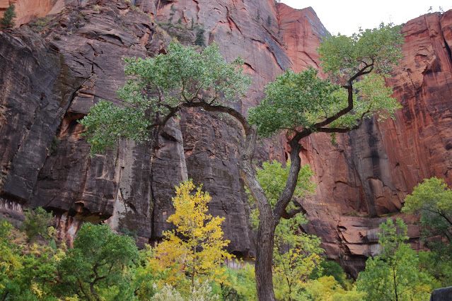
The main "attraction" in the park is visiting the central Virgin River Canyon, see the huge red-pink colored mountains towering above you on both sides of the main road.
Here, in this canyon you will have the opportunity to hike some of the best trails in the US.
Related National Park Blogs:
Where? :
Located in the south west part of Utah,
The park is less of 3 hr north of Las-Vegas, half an hour drive east off of highway I-15.
The town of Springdale is located just on the park west entrance on highway 9.
Highway 9 cross the park west-east and is open all year to traffic. From the east park entrance it is about 1.5 hour drive to get to Bryce National Park.
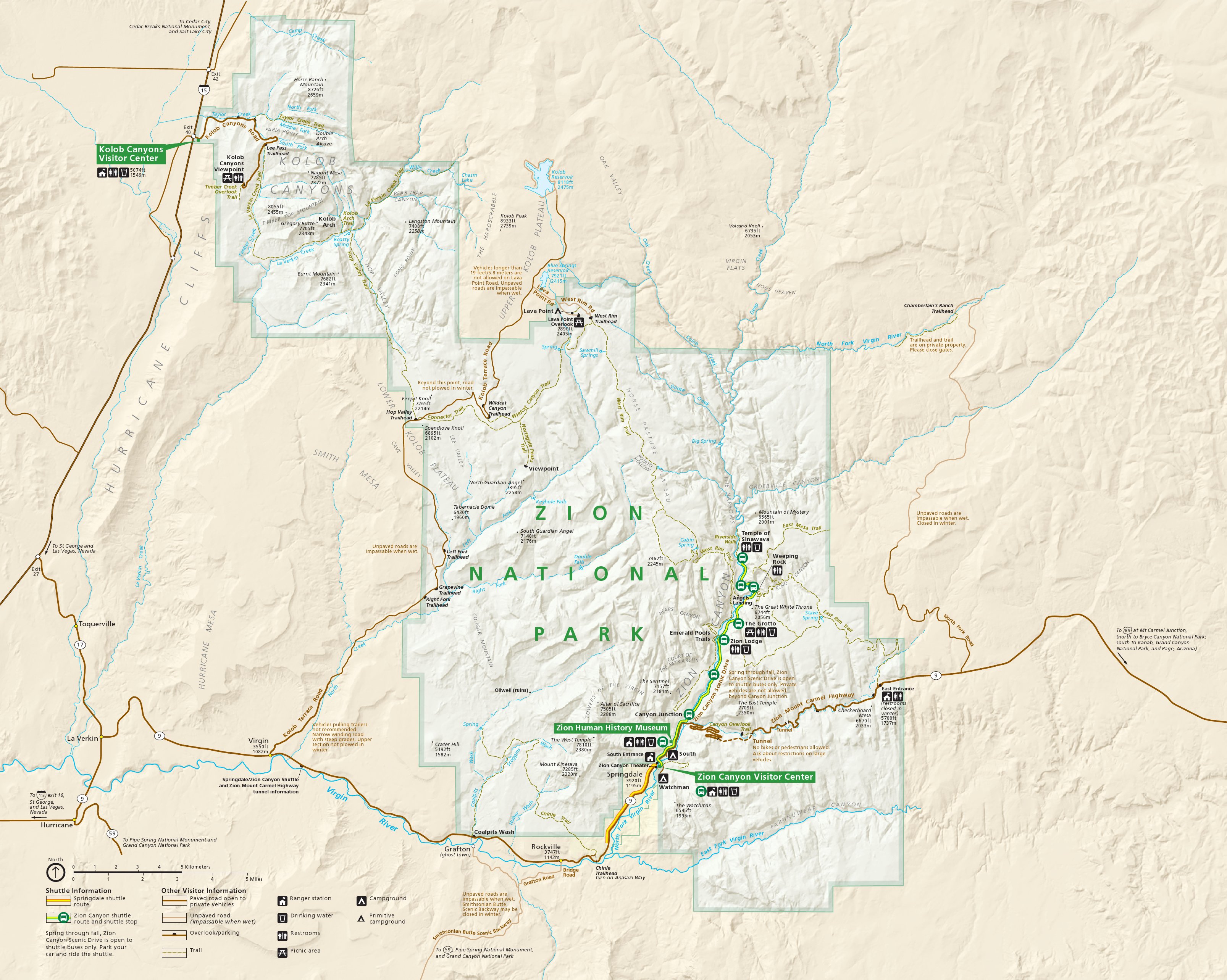
Google Map Link


When? :
Year round park, It will probably be hot at summer or cold at winter (snow) but every
season bring it beauty to this park.


Due
Note 1: You can find hotels at the town of Springdale located just at the park
entrance (there is a shuttle from the town main road into the park visitor center).
Due
Note 2: At most of the year months you can't drive into the main canyon road - you do have free shuttle service starting from the park visitor center, located near the south west entrance. Always look in advance at the park website, check for shuttle arrangements
and open of locations/trails.
Due Note 3: Some of the trails need special permit (like: Subway, and the last section of Angels Landing hike), some are close because of seasonal flooding, rock instability, check in advance.
Due Note 4: This is a VERY popular park so try to arrive early morning to get the shuttle in or late at the afternoon, another option is to use bike to get to the different trail head spots. During late morning (~10am) the park visitor center parking lot can get full so you will need to park your car at Springdale and take a shuttle into the park, thing that add a lot of time, come early and park near the visitor center.
Due Note 5: When coming from the west on highway 9 that cross the park, once you are passing the visitor center there are only few parking spots in the main valley, keep driving until you find one or start to climb the road in the direction of the tunnel, there are more parking over there but this will be good only for short stops for the view.


My thoughts:
One of the best US National parks, amazing view and probably two of the most
iconic hikes in the US: The Narrows and Angels Landing.
I see it as a must visit park, even if this is only one day visit, take the shuttle and do one hike in the main canyon, driving through highway 9 crossing the park, enjoy the view and stop on the way for inspiration.


The
Visit:
Usually
when people are saying "I visit Zion National Park" they are referring to the main park section where highway 9 is crossing
the park from west to east (the main west park entrants and visitor center are right after the town of Springdale) and the main park canyon.
You do not need a permit or reservation to enter the park, but you do need to pay the park fee.
You do not need a permit or reservation to ride a park shuttle.
You do not need a permit to hike the Narrows from the Temple of Sinawava going upstream in the Virgin River.
Angels Landing hike: you do not need permit to hike to Scout Lookout viewpoint, but you do need permit to keep walking all the way up to Angels Landing.
See latest information at:
Because
Zion park is popular park it create visitors load.
The road entering into the narrow canyon has only limited parking locations.
March through November (and holidays weeks in
the winter) you can’t drive into the main Zion valley road with your car (turnout of highway 9 that is open to traffic year round).
There is very efficient shuttle bus service that will take you into the park road.
You can park your car near the visitor center (located near the park southwest entrance) and take the shuttle from there.
I will recommend coming early in the morning (before 9am) to easily find parking spot.
If the visitor center parking lot is already full and you can't find any parking spot you need to drive out and park your car at Springdale main road (paid parking). from there take the local shuttle bus to the park visitor center.
The "busy session" end at Oct. 31 so check arrangement in advance at the park website.
If you are staying overnight in Springdale there is local shuttle from the hotels that take you into the park visitor center, from there you are taking the park shuttle that stop at all points along the main park road.
Shuttles arrive about every 15-5 minutes on the Zion Canyon Line (inside the park).During the shuttle season visitors cannot drive personal vehicles on Zion Canyon Scenic Drive.
Shuttles take about 45 minutes to drive between the Zion Canyon Visitor Center and the Temple of Sinawava. This means a round trip takes about an hour and a half but you may need to wait for the next shuttle.
Check
at park website for more information:

Hikes
and Places to visit in the main park valley:


In this blog I will only describe the main park attractions alongside Zion Canyon and I will not cover the less visited park sections.
Hikes
and Places to visit in the main park valley:
I will cover the following locations:
- Angels Landing Trail
- Emerald Pools
- The Narrows
Angels Landing Trail
The best trail in the park and one of the most iconic trails in
the US !
The trail starts at shuttle Grotto stop.
From here you need to cross the bridge to the other side of the river.
The paved trail start to climb the cliff side in a steep ascend, after many switchbacks and impressive view to the valley below the trail get into a side narrow canyon called Refrigerator Canyon.
Additional climb in the side canyon and another long set of steep switchbacks will take you into
the open ridge section and Scout Lookout point.
From here you have a nice view down to the river canyon in both directions.
You do not need hike permit for this section, take a rest and enjoy the view.
From here you keep climbing up if you have a hiking permit or you hike down the same way you came.
Overall from Grotto stop to Angels Landing this 5.4 mile round-trip hike, you will gain 1,488 feet in elevation.
This is not an easy hike but very rewording, most hikers take around 4 hours to complete the hike.

Update as of 2022:
From the Scout Lookout to Angels Landing you need to have a hiking permit.

From Scout Lookout point you can continue climbing up on a VERY steep and narrow trail that with
the help of metal chins you can go on and climb the narrow cliff.
This section is very narrow, you need to give other direction traffic "time-share" the chains so progress can be very slow.
Although it looks like trail is going straight up on the narrow
cliff it is not long (1/2 mile) and because of the slow past and rests you you are taking you can do this section without so much physical difficulties.
Reaching the top of the mountain is rewording moment, the view down into the main valley in both sides and the surrounding mountains is amazing.
Hiking up this trail from the bus stop is ~3 hr (so bring enough water and some food with you), going down is ~1.5 hours;
Hiking timing is dependent on your shape and on the slow narrow section, this can take much longer time if there are many people on the trail.


Emerald Pools:
This short and easy to hike trail will take you to the lower section of a high waterfall that
creates humid micro environment, the last time when we were there (and of 2019), due to a landslide
you can only hike the trail that start at Grotto stop.

The Narrows
This hike is another "must do" hike and iconic canyon to visit.
Starting from the last bus stop (#9 Temple of Sinawava) you are starting your visit at Riverside Walk trail.
This section is flat, easy & paved and can be done also with small kids.
After 1 mile of walking alongside the river the paved trail ends. From this point you are walking in the water into the narrow part of the canyon.
People that do not want to get wet turn around here, even without getting into the water this hike is highly recommended.
You can walk into the canyon as far as you want, the longer you hike it become less crowded. The river water are cold and depending on latest rains it can be in some sections up to waist deep.
There is an option to rent in Springdale special waterproof boots and pants.


Hike Planning:
My recommendation is to do The Narrow trail late at the afternoon when most people already start to hike back out of the canyon.
At mid day you will have many other hikers at the narrows so you will not have the option to really enjoy this narrow river canyon.
Check last shuttle schedule and plan accordingly.
Please be aware of flash-flood warning.
The water in the river are cold but this hike can be done also at winter as long as the water level are not running high (I did it when it was snowing).


Other hikes options:
There are many other hiking options along the Virgin River in the valley, starting from the visitor center and the campground and also hikes that climb the steep canyon walls.
There is the long hike to Echo Canyon Passage and Zion Observation Point (this trail is close due to huge rock slide so check in advance);
I never
hike them so can’t really recommend.

Places
to visit outside of the main park valley:
Canyon Overlook:
This is a short easy 1/2-mile trail starting right at the upper end of the long tunnel.
The nice and short trail is going all the way to the canyon cliff edge, from that point you will have a nice view on the Zion canyon below you and the high mountains in front of you (The Sentinel and West Temple).
Try to park at the Canyon Overlook Trail Parking, right after the tunnel exit on the right side (this is very small parking lot for only handful of cars) or few hundred feet up the road on the left side.
It is very
difficult to find parking spot in both places so see where you can park on the
roadside and walk back to the trailhead.
This viewing point is a perfect spot for sunrise when the sun starts to light the mountains or when
sunset behind the mountains.

There
are many viewpoints stops along the main road, Checkerboard Mesa is probably the most
famous one.
Kolob Canyons Visitor Center:
This is the far north west section of the park were the entrance is from highway I-15 (exit 40).
This park section visited by fewer people. You need to pay entrance fee to the park and you also need park permit if you are planning overnight backpacking.
If you are not planning to do here few days hike, I will recommend skipping this section and visit only the main park section, on the other hand if you have more than one day for your Zion visit or you are driving on I 15 this can be a great option to see Zion beauty, drive up the 6 mile road enjoy the view or have do a hike.
Many years ago we spend in this park section 3 days backpacking and it was excellent, less people and
impressive mountains and canyons.

Another
famous hike in Zion National Park is "The Subway":
I never
did it so can’t give more information except that hike start at Left Fork
Trailhead on Kolob Terrace Rd. and the Subway section looks amazing… this is still on my todo
list.
Due popularity you must get hiking permit to this location, must order permit in
advance!
Web
site:
https://www.nps.gov/zion/index.htm
Map:
http://npmaps.com/wp-content/uploads/zion-map.jpg
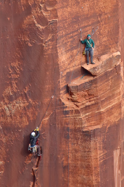
Additional Pictures:


Comments
Post a Comment