
Introduction:
What? : This hike will
take you into Desolation Wilderness and to Susie Lake. From the Glen Alpine
Trailhead to Susie Lake, it is 4 miles hike, most of it is upward with about 1,400ft
of elevation gain (overall 8 miles hike of out and back hike).


For a Beautiful Nature Prints - Visit my Etsy Store
Where? : Starting at the Glen Alpine trailhead: To get
to the trailhead, drive to Fallen Leaf Lake in South Lake Tahoe, drive past the
summer homes and marina until you reach a small firehouse on the left side of
the road. Keep driving up the single lane road until the end of this road, here,
near Lily Lake, you will see the trailhead board and parking lot.
Google Map Link

When? : The trail get
cleared from snow at late spring so the preferred season to hike here is at
summer and fall.
Bear at South Lake Tahoe
Emerald Bay State Park – Lake Tahoe
Eagle Lake Hike – Lake Tahoe
Emerald Bay State Park – Lake Tahoe
Eagle Lake Hike – Lake Tahoe
Due note 1: This trail is
popular and if you will come late the small parking lot at the end of the road may
be full so you will need to drive down and look for roadside parking.
Due note 2: Desolation
Wilderness permit is needed (you can get it at the trailhead; Overnight camping
permit is mandatory; no campfires allowed at all in this Wilderness Area
(year-round); your tents must be at least 100 feet from the water’s edge.
Due note 3: Dogs are
welcome and may be off leash in some areas; dog waste must be buried.

My thoughts: My plans were
to do this hike as part of a much longer loop hike in the Desolation Wilderness
but at the end because of bad weather I only hiked to the lake and back. When I
started the hike at 7 am it was cold and windy, and you can see the storm clouds
coming from the west. 20 minutes into the hike it starts to rain, light at
first but when I arrived Mineral Spring site, one mile into the hike, it was
already heavy rain.
When I climbed
out of the valley the low clouds cover the landscape with fog and heavy rain. I
was not so much ready for such heavy rain, and I got completely wet, I was
worried that my camera (Canon 90D) will get ruined by the rain, so I took only
few shots.
When I reached Susie
Lake, I saw that the low clouds are not clearing up and I can’t enjoy the view,
so I decided to turn around and hike back to my car.
I need to re-do
this hike in better weather conditions.


The Hike:
I arrive Fallen
Leaf Lake early morning, took the south lake single-lane road all the way to it
end and parked at the trailhead parking lot.

The hike is
rated as moderate, but I did not find it too difficult even at the climbing
sections that are gradually climbing the rocky cliff sections.
When I started my
hike, it was windy and the skies were dark with thunderstorm clouds, 20 minutes
into my hike it starts to rain, it rained through all my 4 hours hike.
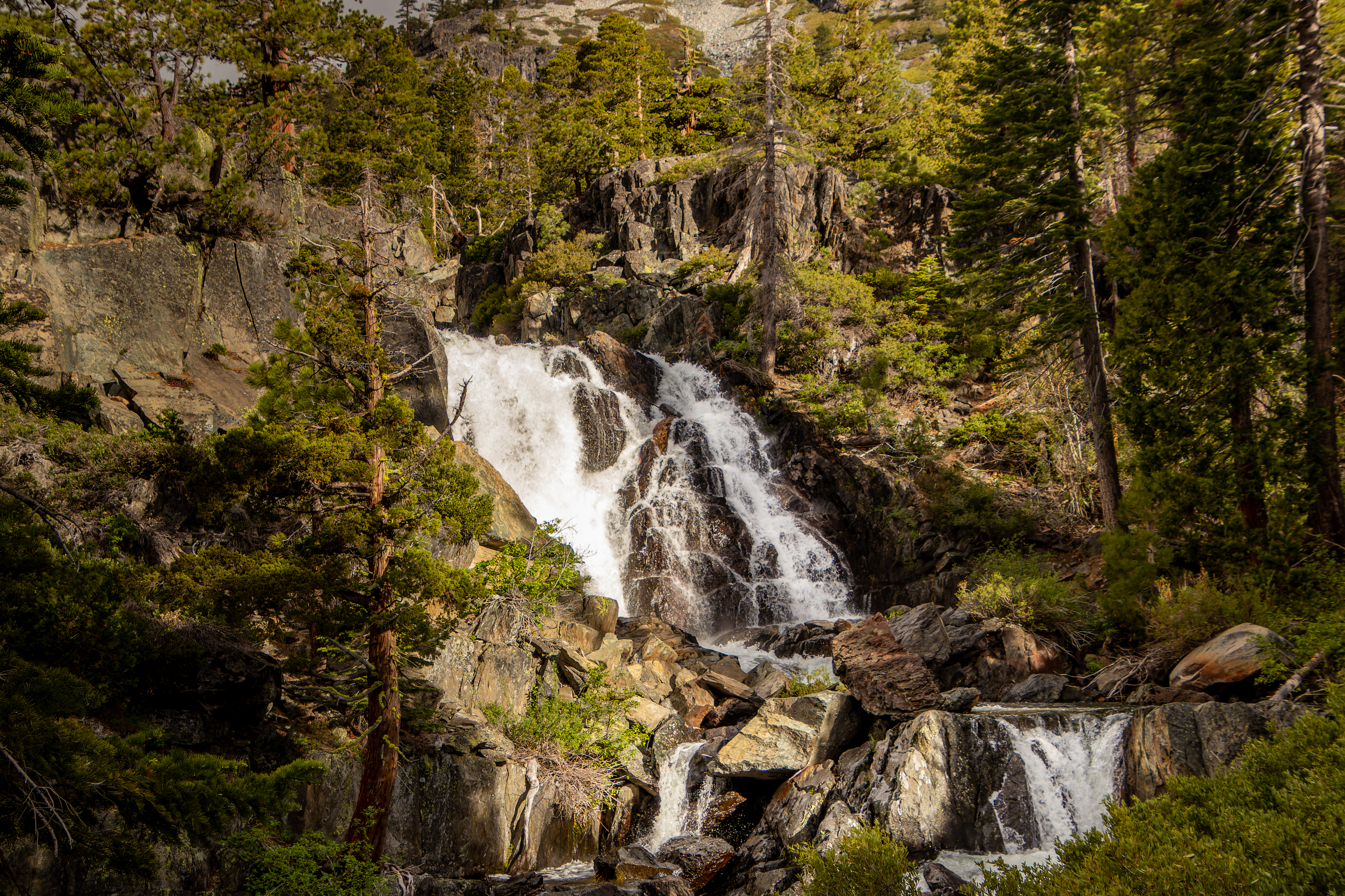
Before reaching
to Glen Alpine Springs site, you pass near a large waterfall on your left side.
A short but clear side trail led to the base of the waterfall.
After 1.1 mile
from the parking lot, hiking on the old dirt road, you will reach Glen Alpine
Springs historical site that was active in the 1880s. This is the location of
mineral water health camp. The mineral spring is still there (cold water
spring) and there are few standing maintained building at this location. When I
arrived here it was heavily rained, and I did not explore this location.


From here the single-track
trails begin and after short hike up you will get into the Desolation
Wilderness. The trail zigzagging up the mountain side in few switchbacks, crossing
large dense forest sections and once the trail get to the rocky mountain slops
the landscape view cleared up.
Unfortunately, when
I hiked here a storm got into the area bringing with it heavy rain, low clouds,
and high wind and all the surrounding mountains and the valley below were
covered with clouds and fog.
The heavy rain increases
the creek water flow and I had to cross it over large pile of trees and logs
that were stack in the creek and created a dry way to pass it to the other
side.

At mile 3.13 from the hike starting point where the trail finished the climbing section and level up in the forest you get to the trail junction leading toward Gilmore Lake or Susie Lake.

Keep left for Susie Lake, after passing few small ponds and additional 0.5 miles you will connect to the
PCT, turn left here. After additional 0.4-mile hiking level you will reach your
destination, overall, this is 4 miles from the starting point.

At the lake the
wind was blowing strongly with low clouds and rain, I can’t enjoy the view and
by that time I was completely wet and cold. I decided to end my hike here and
not to progress deeper into the mountains.

I can only imagine
the views of the lake and surrounding mountain peaks, but I can’t see a lot
from that landscape.

www:
https://www.fs.usda.gov/Internet/FSE_DOCUMENTS/fsbdev7_018772.pdf
https://web.stanford.edu/~yesavage/DWTPG.pdf
Pictures:


Comments
Post a Comment