
Introduction:
Update: Last update this website: Dec. 2022
Where? :
Located in Saratoga, the small parking lot is located at the end of Prospect Rd.
What? :
Fremont
Older is the nearest park to my house and I visit here many times.
Only 15 min drive
from the south bay cities and after a short hike up the hill you are finding yourself in a open space where you can
hike (also with kids, no strollers, dogs on leash allowed), run, or mountain bike for many miles.
The
park has few nice south-valley viewpoints at the hilltops (Hunter's Point, Maisies
peak, Nob Hill).
Although, located in the city of Saratoga this is not a "city park" but rather more a "real" park where you can enjoy the outdoors and hiking in nature.
Although, located in the city of Saratoga this is not a "city park" but rather more a "real" park where you can enjoy the outdoors and hiking in nature.


There are many animals you can see in the open space, on top of deer’s I saw here wild turkey, coyote and bobcats.
There is always something interesting to see in this park and the south valley view from the hilltops is rewording.

- McClellan Ranch Preserve
- Rancho San Antonio Preserve
- Stevens Creek paved Trail (Sunnyvale to Waterfront)
- Stevens Creek County Park & Lake
- Pearson-Arastradero Preserve
- Villa Montalvo
- Saratoga Quarry Park
- Bay Waterfront Trails
- Don Edwards and Alviso Marina County Park
- Vasona Lake County Park
- Los Gatos Creek County Park

When is the best time to visit here:
Very small parking lot so plan accordingly
Mid day weekends and holiday are problematic
Preferred time is early morning (before 10 am) or even better come late afternoon (this is also a better time for wildlife viewing)
Due Note: As many other local parks you should be outside the park half hour after sunset
Due Note: Restroom: portable restrooms in the parking lot
No water
Due Note: Year round park. It can be muddy after rain.
Shade: There is no shade in most of the trails, ridgelines and viewing points.
Due Note: Mountain bike friendly, do expect to see them on almost all park trails
Dog (on leash) friendly
Horses from the nearby ranch
Due Note: Drones are NOT allowed on any preserves.
The Visit:
Parking:
The parking lot is small and if no parking spot is available you need to look for parking ¼ mile down the road and walk up to the parking lot.
Another option is to park at Prospect Rd. and take the longer 2 miles Parker Ranch Trail (Purpule line in the map below) into the park main section (the ridgeline trail).


Recommended Hiking Trails:
Option 1:
Out and back hike to Hunter's Point (1.67 mile, 330 ft elevation gain).
This is the most popular hike in the park and you will always see other hikers along this trail.

Option 2:
Short Lower Loop (3 mile, 617 ft elevation gain):
Cora Older -> Hayfield Trail -> Hunter's Point -> Seven Spring loop

Option 3:
Up the high Ridgeline (4.3 mile, 800 ft elevation gain):Cora Older -> Hayfield Trail -> Toyon Trail-> Bay view trail-> Coyote Ridge -> Maisie's Peak-> Coyote Ridge (south)-> Parker Ranch-> Toyon Trail-> back to starting point
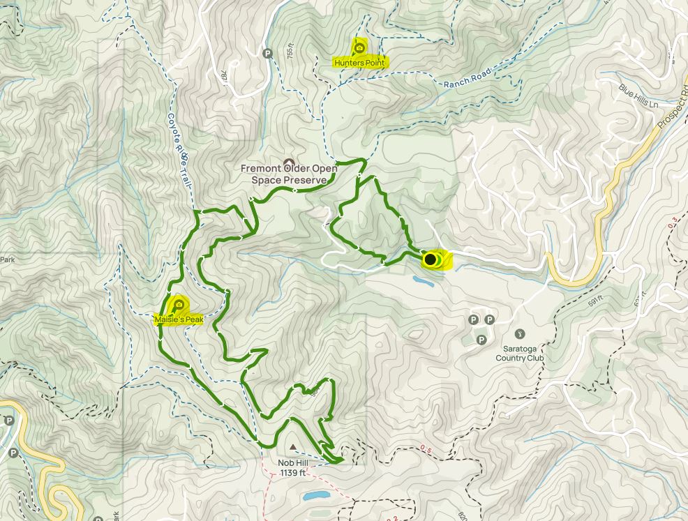
Link to AllTrails
Long climb to high ridgeline (6.3 mile, 1,000 ft elevation gain)
Bike are not allowed on this trail
Option 4:
Trail Head at Parker RanchLong climb to high ridgeline (6.3 mile, 1,000 ft elevation gain)
Bike are not allowed on this trail

Long loop hike down to the lake
Bike are not allowed on this trail.
Cora Older-> Hayfield Trail-> Coyote Ridge (north) all the way down to Stevens Creek park-> Stevens Creek Tony look trail (left)-> near the end of the lake trail (it is getting into dead-end) take left into Tony look trail-> passing Stevens Creek Tony Look Trail Head-> lookout trail up the ridge-> Vista loop trail-> Coyote Ridge-> down back to parking lot
Cora Older-> Hayfield Trail-> Coyote Ridge (north) all the way down to Stevens Creek park-> Stevens Creek Tony look trail (left)-> near the end of the lake trail (it is getting into dead-end) take left into Tony look trail-> passing Stevens Creek Tony Look Trail Head-> lookout trail up the ridge-> Vista loop trail-> Coyote Ridge-> down back to parking lot


Biking:
There are many trails for bike, some are close during winter.
If you are going down to Stevens Creek lake you must go up the same way or by using the road.
The Tony-Look trail and the Lookout Trail are close to bike.

My Take:
This is one of my preferred local parks, nature escape experience, 15 minute drive from home, not so crowded, with a lot of animals to watch.
For specific and up-to-date park guidelines and regulation please check the park website.
www:
Map:
https://www.openspace.org/sites/default/files/map_FO.pdfMore Pictures from the my park visits:


Comments
Post a Comment