
Introduction:
What? :
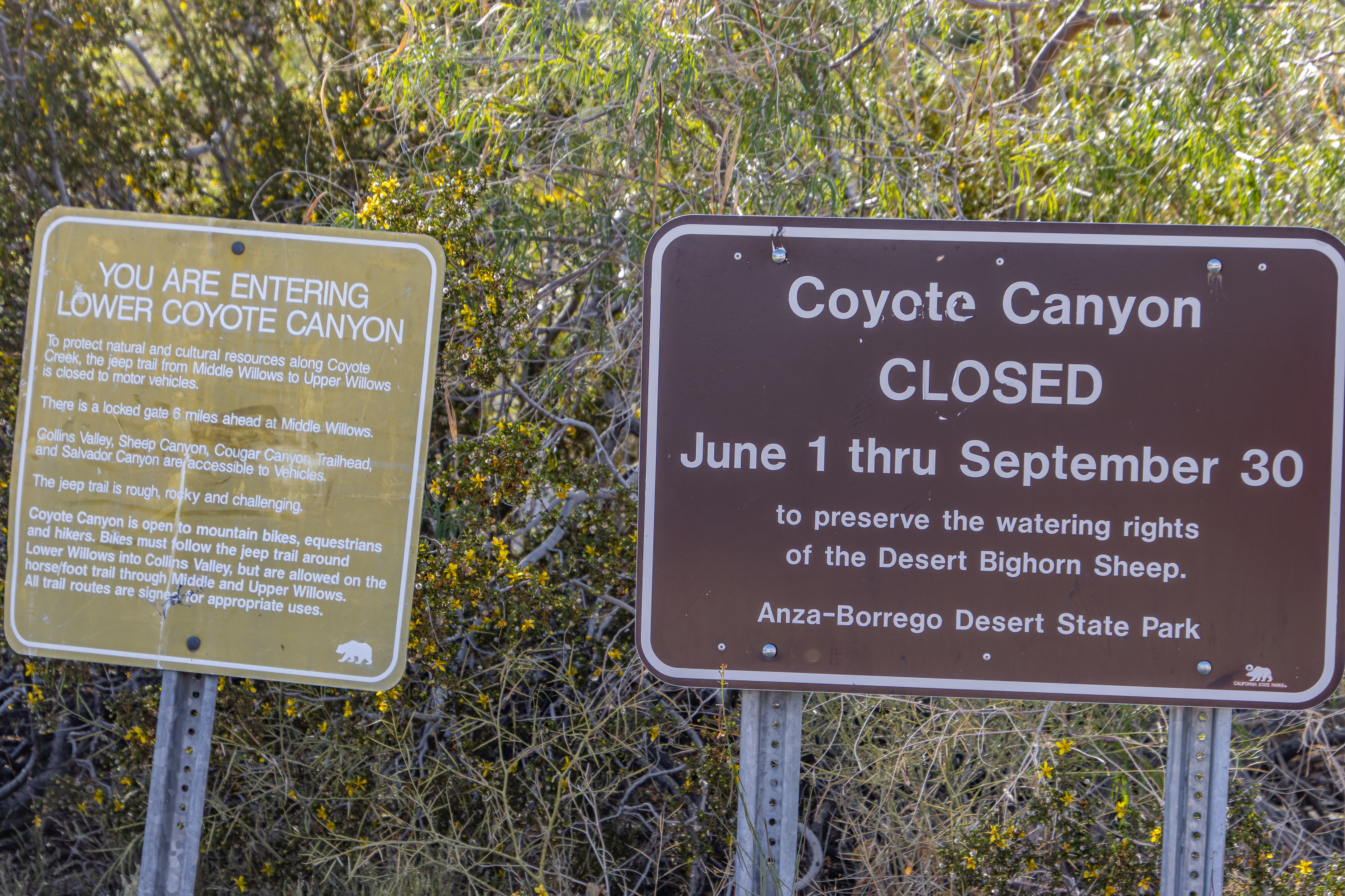
Coyote Canyon
is about 35 miles long canyon located in northwest of Anza-Borrego Desert State
Park in the Colorado Desert of Southern California. It is a popular destination
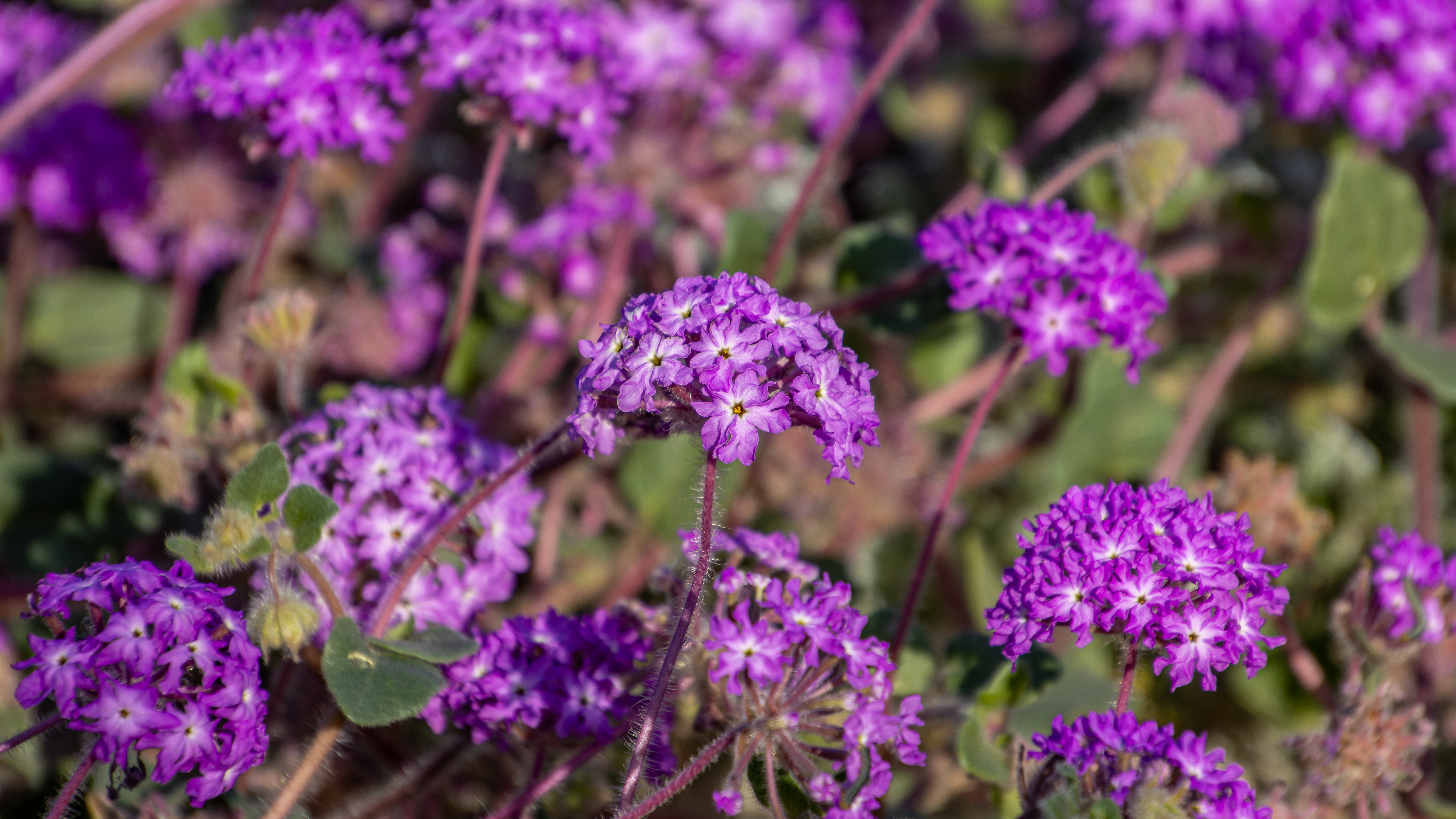
for off-road driving, camping, and hiking as well as spring flower bloom
viewing.
Lower Coyote
Creek is the only perennial year-round stream on the eastern side of the
Peninsula Ranges.


Overall, this
drive was 15 miles long out and back and it took me with many stops for short
walks and taking pictures about 2 hours.

For a Beautiful Nature Prints - Visit my Etsy Store
Where? :
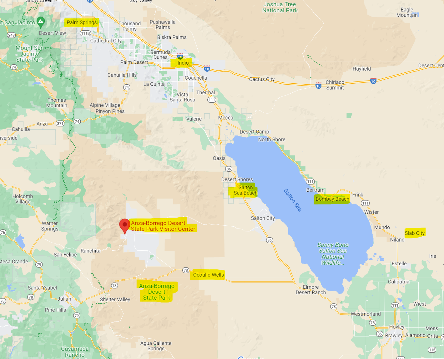
Located in
Anza-Borrego Desert State Park in the Colorado Desert of Southern California, about
one-and-a-half-hour drive south of Palm Springs or two hours east of San Diego.
From Anza-Borrego
State Park Visitor center drive to Borrego Springs circle, keep driving east on
Palm Canyon drive and turn left into the first road, Di Giorgio Rd. Drive north
for about 4.8 miles and you will reach the start of the dirt road leading into Coyote
Canyon.
At this location
you will see on your right few signs and Wildflower Viewing Area.
Google Map Link
Nearby Destinations:
- South East California Desert:
- Painted and Ladder Canyon, Mecca Hills Wilderness, California
- Bombay Beach and Salton Sea (CA)
- Salvation Mountain and East Jesus - Slab City (CA)
- Anza-Borrego Desert State Park:
- Anza-Borrego Desert State Park (CA)
- Wind Cave - Anza-Borrego Desert State Park (CA)
- Ricardo Breceda Metal Sculptures - Borrego Springs (CA)

When? :
The park is open
year-round, but the summer month are extremely hot (~110-120f mid-day), I
highly recommend visiting here during to colder month of the year.
November
through February has highs in the 60-70s and lows in the 40s. April and May are
already getting to 80s, and June starting to more than 100f.
Important note:
The deep section of this trail is
closed between June 1st and September 30th to preserve the watering rights of
the Desert Bighorn Sheep.
Due note 1: There is a gas
service, stores, and many other facilities in Borrego Springs.
Due note 2: no matter if
this is a short or long walk, make sure to have with you a lot of water and
sunscreen.
Due note 3: This is a
prime offroad 4x4 destination.
All roadways in
Anza-Borrego Desert State Park-dirt, sandy wash, or paved are considered a
road.
All vehicles
must be highway legal per the California Vehicle Code and must remain on all
designated roadways.
All Off-Road
Vehicles are prohibited in the park.
Due note 4: After rainstorms
in the mountains to the west you can have situation of flash floods in main
river washlands. Check the weather before driving into your offroad trip.

Due note 5: Few offroad and
hiking tips:
·
Do not hike alone.
·
Tell someone about your trip plans.
·
There is no cell reception, I highly
recommend to have gps communication system.
·
Carry a map and use it, Download
Offline Maps and GPS Prior to Arrival.
·
In your car carry extra water,
shovel, tools, flares, and blankets.
·
Check the road condition board at
the visitor center before you start out.
·
If you offroad make sure you have
good spare tire and repair tools and that you know how to replace a flat tire.

Due note 6: there is a
large Campground in Borrego Palm Canyon, not so far from the visitor center.
Due note 7: Un like many
other states parks the entire backcountry area of Anza-Borrego Desert State
Park is defined as a camping facility, free of charge.
You can camp
overnight almost anywhere you want, as long as your car is not parked more than
one length off the road, please follow BLM camping guidelines.
Due note 8: The small Borrego
Springs town is located in the center of the Anza-Borrego Park and has few
hotels.
Due note 9: Drones are
prohibited in the airspace above the reserve.

Due note 10: Open fires,
including campfires and barbecues are prohibited at Blair Valley Primitive
Campground, Culp Valley Primitive Campground and any backcountry campsites and
day-use parking areas. Portable propane
or gas stoves are permitted for cooking only within designated campsite and
day-use areas.
Due note 11: Cell phone
coverage is spotty or nonexistent when you are getting into the desert.
Due note 12: Dogs are
welcome in the designated campgrounds, on designated roads where vehicles are
allowed. They are not allowed in the backcountry, on trails, or in the
wildflower fields.
Due note 13: The trail is
mostly easy but not suited for conventional vehicles after about 3.5 miles due
to soft sand, water crossings and a rocky climb.
Due note 14: Four-wheel
drive and high clearance vehicle is necessary when driving into the far section
of Lower Coyote Canyon.
Due note 15: The canyon
trail is closed to vehicle traffic between Upper Willows and Middle Willows, you
must turn back and exit at the same road you drove in
Due note 15: There is also
upper canyon section but to you need to enter it from the west side, from Anza,
CA, outside the park.

My thoughts:
If you're
looking for a place to experience the beauty of the south California desert, then
driving up Lower Coyote Canyon in Anza-Borrego Desert State Park is excellent 4x4
offroad destination during the cooler month of the year.
This is a prime
destination for offroad long drive activities that can be combined with short hikes.


The Drive:
Juan Bautista
de Anza first passed through the Borrego Valley using this route in 1774, on
his first route-finding mission to the new Spanish settlements in California.
This canyon
passing up and provide a relatively easy way to cross the high coastal range
mountains.
You will start
your dirt road drive where there is a large agricultural area on your left,
after about half a mile the agricultural land ends and you are driving into the
large desert dry wash area.
The road turn
to the west into the direction of the canyon on the right side of the large alluvial
fan.

After about 2.9
miles from your start, you will reach a small section called Desert Gardens on
the right side of the road, this is an excellent point to stretch your leg with
a short walk among the cacti and other local plants.


Short drive
after this point you will reach the first riverbed crossing, this will be about
3.4 miles from starting point.
When I was here
the road until this point was in very good condition and well maintained and
all vehicles can drive this road and enjoy this area of the park.
This trail and
creek crossing can change from year to year due to flash flooding.

Usually, the
first crossing of the dry creek is not a problem for standard car, but this may
be wet or deep send so make sure you can pass here.
Here you have primitive
campsite where people can spend the night.
The road start get
rougher and after 4.5 miles you will arrive to another creek crossing, you will
see a large road opening on the left side just before the crossing.
When I was here
(April 2023) this crossing has running water, feet deep and with a lot of large
rocks. I learn that this section and the next 2 crossing has water year-round.

Do not try to
drive here with regular car, you may stack on the rocks, to pass this you will
need a 4-wheel-drive and high clearance vehicle.
When I was here
a high clearance camper tried to pass and got stack on the rocks, another jeep
had to pull it back.

Keep driving up
the trail after this crossing and you will reach the gate.
The upper section of this trail is closed between June
1st and September 30th to preserve the watering rights of the Desert Bighorn
Sheep.

After another
short drive the trail turn left, and you will reach another creek crossing.
This point is
about 5.2 miles from your starting point.
Check the water
and mud condition when crossing here, give it some momentum when passing.

From this water
crossing the trail climbing a relatively steep rocky section climbing up in a
narrow creek to the pass. I read that this section can be bumpy but when I was
here the road was in good condition.
You will arrive
the pass after 6 miles from the trail start.


Here the view open,
find an offroad place, park, get outside the car and enjoy the view to the
west.
The large Collins
Valley will be below you and in the far side of the valley you will see the tall
Santa Rosa mountains range, where the PCT trail pass.

I saw in the
map that you can drive here to the right in the direction of the Santa Caterina
Spring, but it was almost sunset, and I want to drive into the valley.
After passing
the high point, the trail changed onto a packed sandy surface, and it start short
descends into Collins Valley.
The road reach
the valley floor and here it is surrounded by relatively high vegetation,
different from the more open arid desert landscape of the hills.

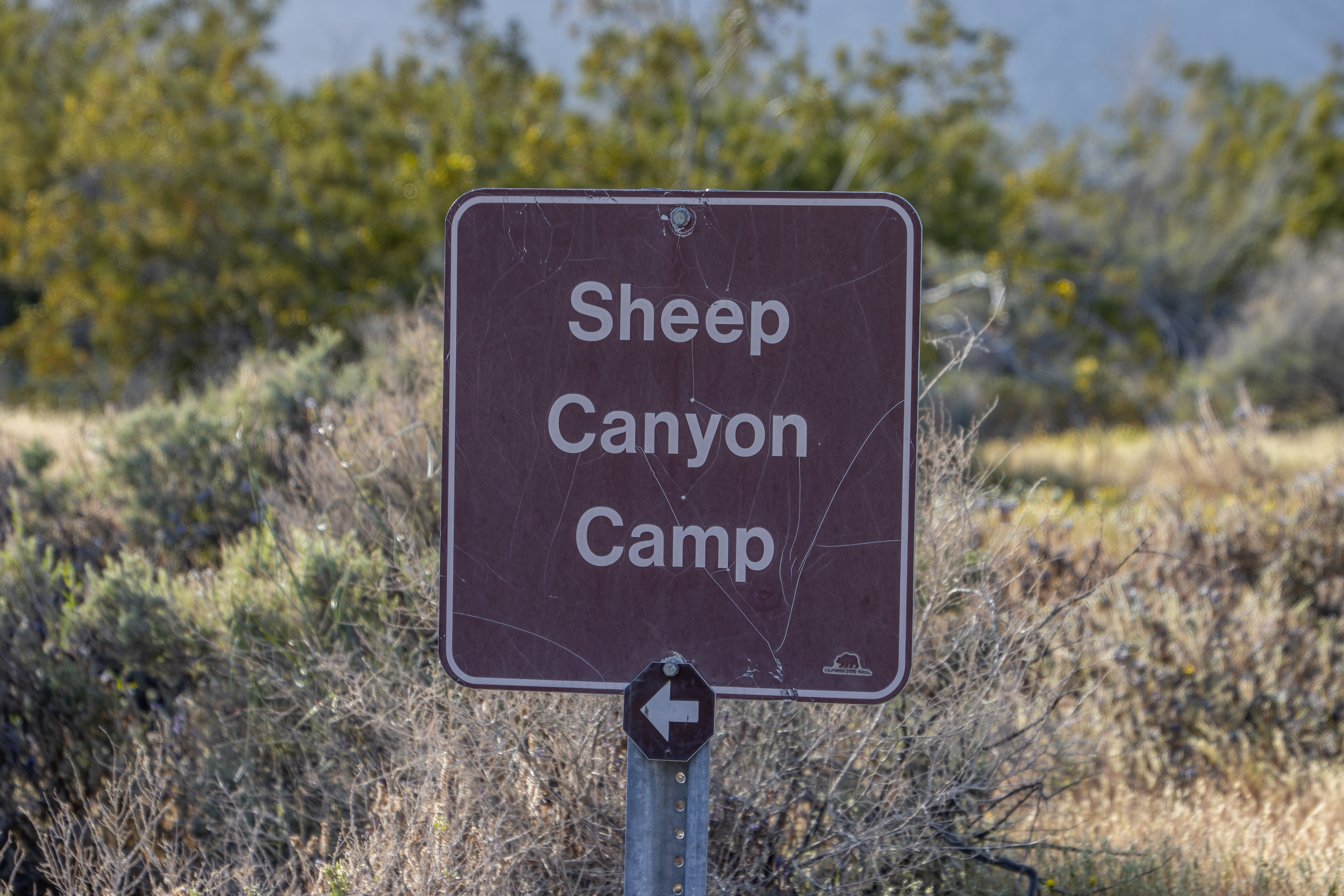
After 6.9 miles
you will reach a marked trail junction, turning left will take you to Sheep
Canyon Primitive Campground, I turn right here.
After a short
drive in the valley (7.2 miles from start), you will see a small parking on the
right side of the road, this is the nearest point to walk to the nearby palm
trees.

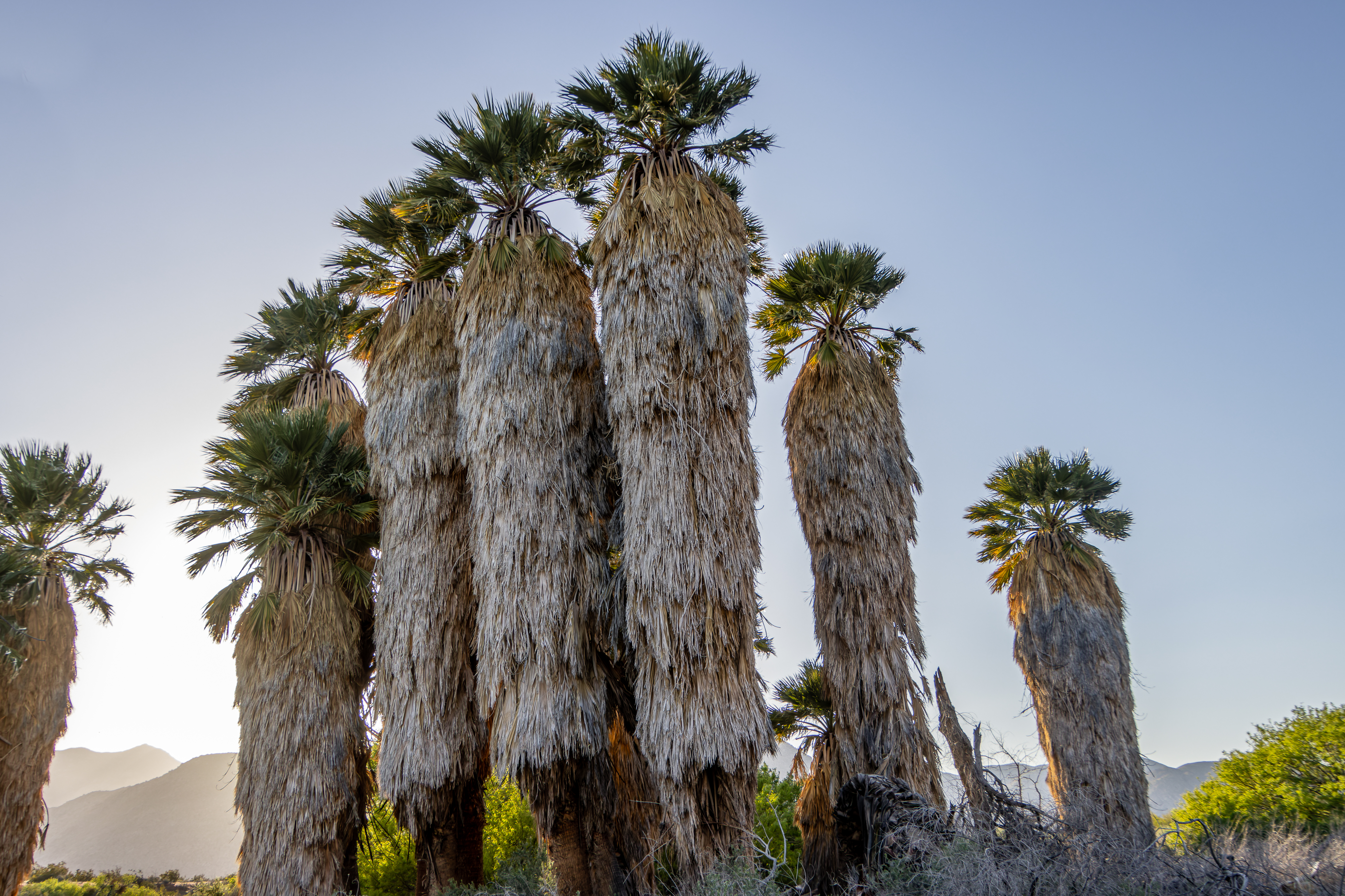
This is a large
spring is a major source of Coyote Canyon’s year-round water supply, all the
creek near the hill is covered with tall vegetation and many palms tress, a
real desert oasis.

The California
fan palms are the only palm native to California and here you can find many large
trees.
After a short
walk on the trail, you will reach the palm trees.


I went back to
my car and start with my ride back out.
The Lower Coyote
Canyon offers number of hiking trails, starting from the road, and heading to
the nearby mountains or valleys. I did not hike here so I can’t recommend on
any hike.
Overall, this
drive was 15 miles long out and back and it took me with many stops for short
walks and taking pictures about 2 hours.
www:
https://www.parks.ca.gov/?page_id=638
Map:
https://www.parks.ca.gov/pages/21299/files/anza_coyote_canyon_map.pdf
https://www.parks.ca.gov/pages/638/files/abdsp_Park_Map201704.pdf
Additional Pictures:


Comments
Post a Comment