
Introduction:
What? : This scenic
drive on highway 4 corridor, known as Ebbetts Pass National Scenic Byway is one
of the most intimate and less traveled High Sierra crossing routes.
The Scenic
Byway begins in the west at Angels Camp, climb east into the Sierra Nevada
mountains crossing them through Pacific Grade Summit (8,050 ft) on its way up
to the Ebbetts Pass (8,730 ft), from there it is descending into the deep
Silver Creek canyon until it ends at State Route 89
Along the route
you can visit Calaveras Big Tree State Park, lakes, and mountain ranges, and enjoy
outdoor activity in the Stanislaus National Forest.


The Route Map:

Related Blog Posts:
Natural Bridges TrailCaples Lake and Carson Pass (Highway 88)
Fall Colors in California - Trip to Eastern Sierra
California State Highway 108
Where? : State Route 4 start
at the west from Interstate 80 in the San Francisco Bay Area to the east where
it connect to State Route 89 in the Sierra Nevada, this is 190 mile long road.
in this blog I will describe only the eastern section of the highway, starting
at Arnold when it climbs and cross the Sierra Nevada Mountain range.
Google Map Link
When? : This road is
closed at winter after the winter major first snowstorm and it open again late
spring (~May). Some road sections at the west (east of Arnold) are plowed allowing
cars to get to snow parks.
Check for road
conditions before you are heading to your road-trip.
Due note 1: There are practically
endless outdoor destination in this vast, remote area, the northern section of Stanislaus
National Forest protects and manage this region.
I had only few
visits in this area, so I can provide information only on things I did.
Due note 2: This road is narrow,
and winding, single lane in sections, and it is not recommended for tracks RVs
or bus.
Due note 3: Up to Bear
valley you are in Calaveras County and from there driving east you are getting
into Alpine County. It is interesting to know that as of the 2020 Census, the
population in this county was 1,204 people, making it California's least
populous county. The county largest community is Markleeville.
Due note 4: The road on
the west side of the Sierra follows the North Fork Stanislaus River and there
are many lakes, hikes, and campgrounds to find in this remote area.
Driving Warning:
Through the high
mountains section, this road is not suitable for large trucks, buses, or RVs!
My thoughts: I only visit this
road two times, cross the Sierra east to west. This is probably the less travel
road that crosses the Sierra so you will see less people here. we mainly
stopped along the highway for viewpoints and to see the lakes but there are a
lot more things to do here… next time….

The Road Trip:
Road Trip Proposal:
The first time
we came here was to visit Calaveras Big Trees State Park we drove from Angels
Camp up to the park and after our visit we went back.
The second time
was as part of late fall (Oct.) long road-trip from the bay area, we were looking
for aspen trees fall colors viewing.
We started our
trip at Hope Valley (highway 88) and then drove to Markleeville for lunch break
at the local pub & restaurant. From Markleeville we drove on highway 4 up
the pass and continue west all the way to San Francisco Bay Area.
This is a long drive
for one day but the landscape and the views along the drive make it worth.
This ~430 miles
loop drive is the following: bay areaà highway 88 and Hope Valley à highway 89 à Markleeville à Highway 4 à cross Ebbetts Pass to the west à back home.
In the
following sections I will describe the attractions along highway 4 (things we
did or stop at).
I will list the
locations describing the route from west to east, even though we did our drive here
from east to west.
Calaveras Big Trees State Park:
Established in
1931, Calaveras Big Trees State Park preserves two groves of giant sequoias, in
addition to the giant trees reaching up to 250 feet tall, you will find here
many forest trails and the Stanislaus River.

The largest
tree in the park located in the South Grove, this is Louis Agassiz tree,
reaching well over 250 feet in height and 25 feet in diameter.
As part of your
road trip, you can do a short 2 hours visit in the park, exploring the North
Grove or dedicate a full day to explore the South Grove and the park trails.
Link to my Blog
describing my park visit: Calaveras Big Trees State Park.
The park entrance
is located just off highway 4, right east of the town of Arnold.
For more
information visit the park website:
http://parks.ca.gov/?page_id=551
Lake Alpine:
The Lake Alpine
reservoir (elevation of 7,300 feet) located within a granite basin surrounded
by pine forest; drive east of the community of Bear Valley on State Highway 4. The
lake is the central attraction of the Calaveras Ranger District.


Summer visitors
enjoy swimming, boating, hiking, camping, fishing, and many other outdoor
activities.
In winter, the
lake becomes part of the Lake Alpine SNO-PARK.
There are many campgrounds
around the lake, but you need to make advance reservation: https://www.recreation.gov/
Cape Horn Vista Point Picnic Table:
If you will
drive from Pine Marten Campground entrance exactly 2.1 miles east on highway 4 you
will find a small unmarked entrance to the right, where the road bend to the
left. Drive slow so you will not miss it. This is a very short entrance and you
can find here one picnic table.
If the weather
is nice and it is not cloudy, and you did not already rest at the lake this is
probably the perfect location for a lunch break.

The view from
this high location is amazing, you can see for miles to the east all the way to
the high mountain ranges in this area.
Be careful when
you are getting into this location and when you are coming back into the
highway.
If you are
driving west the table is visible but you will need to cut the road to the
other side so, do this carefully.


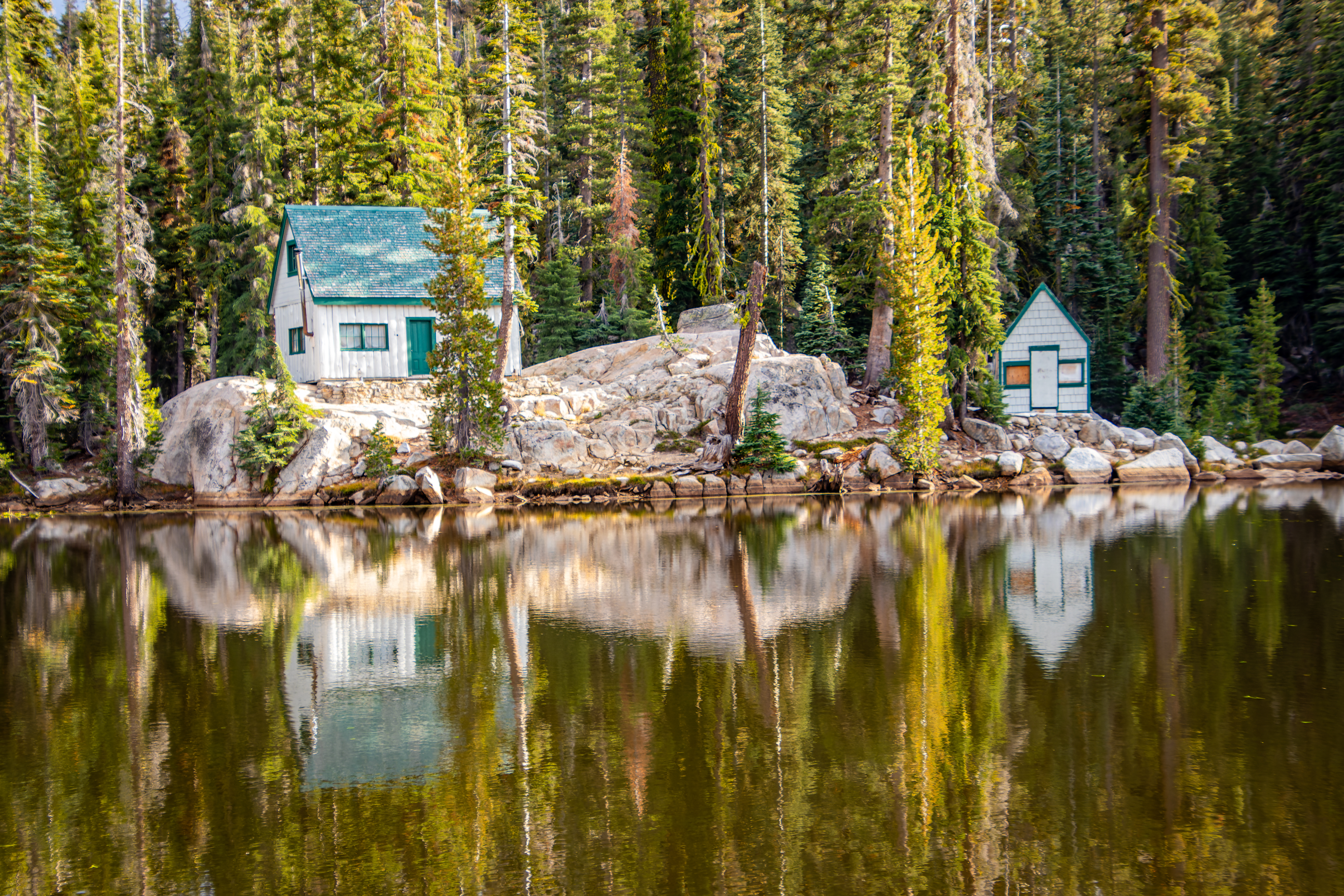
Mosquito Lakes and Pacific Grade
Summit:
This is
probably one of the most photogenic locations I saw in a long time, a small pond with two old wooden houses reflecting by the calm water and surrounding
by pine trees.
I hope that the
pictures deliver it beauty…


Mosquito Lakes
is more likely can be described as 2 ponds rather than lakes.
Here you can
find the Mosquito Lakes Campground and right after (when driving east) you will
bend right, look for parking spot at this place. You can find both on the right
and on the left side of the road.
There is a large
house is the land separating the 2 ponds and you can find on the eastern pond
another 2 small houses.
We did not stop
here for long time, took few pictures, and keep moving on, right after the east
pond you are passing Grade Summit at 8,050 ft.

Ebbetts Pass. And Kinney Reservoir:
Ebbetts Pass at
elevation of 8,730 ft is one of the least traveled passes in the Sierra Nevada crossing
the mountains west to east. This is probably the first Sierra pass crossed by a
non-Native American, when Jedediah Smith crossed the Sierra in spring, 1827.


When driving it
west to east you will almost not feel the pass itself but then you will reach the
steep descent on the east side of the pass.
When driving
west, after short drive you will see Kinney Reservoir on your left, there is a
small place to park here, near the lake dam.
From the Kinney
Reservoir you can hike up to Upper Kinney Lake via a 1.2-mile-long trail (one
way), excellent destination for fishing or for hiking and exploring this area.


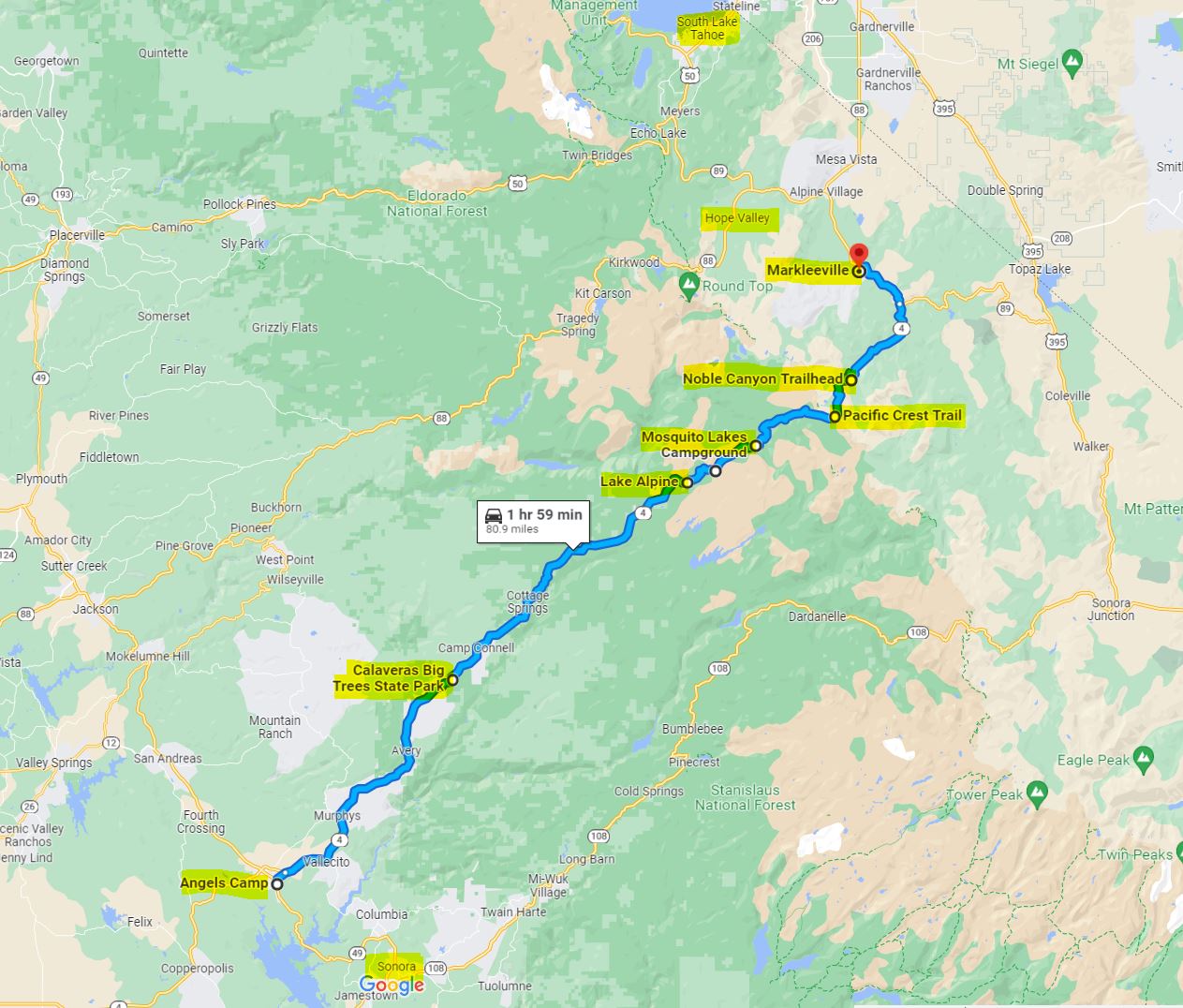
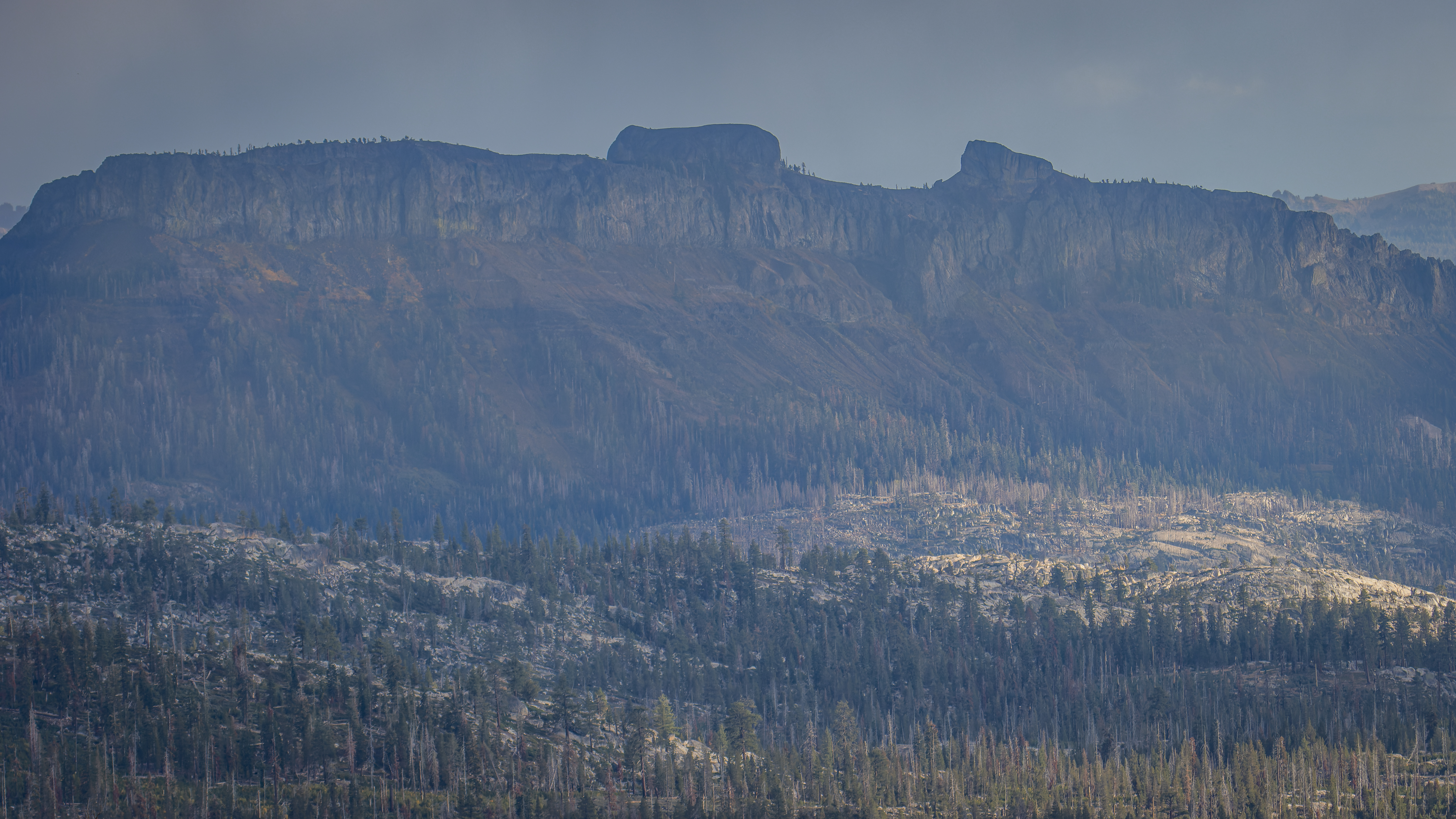
Noble Canyon and Silver Peak view:
After driving
east of Kinney Reservoir, the road start descending gradually along Kinney creek but after 1.5 mile you will get
into a steeper section. Now you are driving into Noble Canyon, this section of
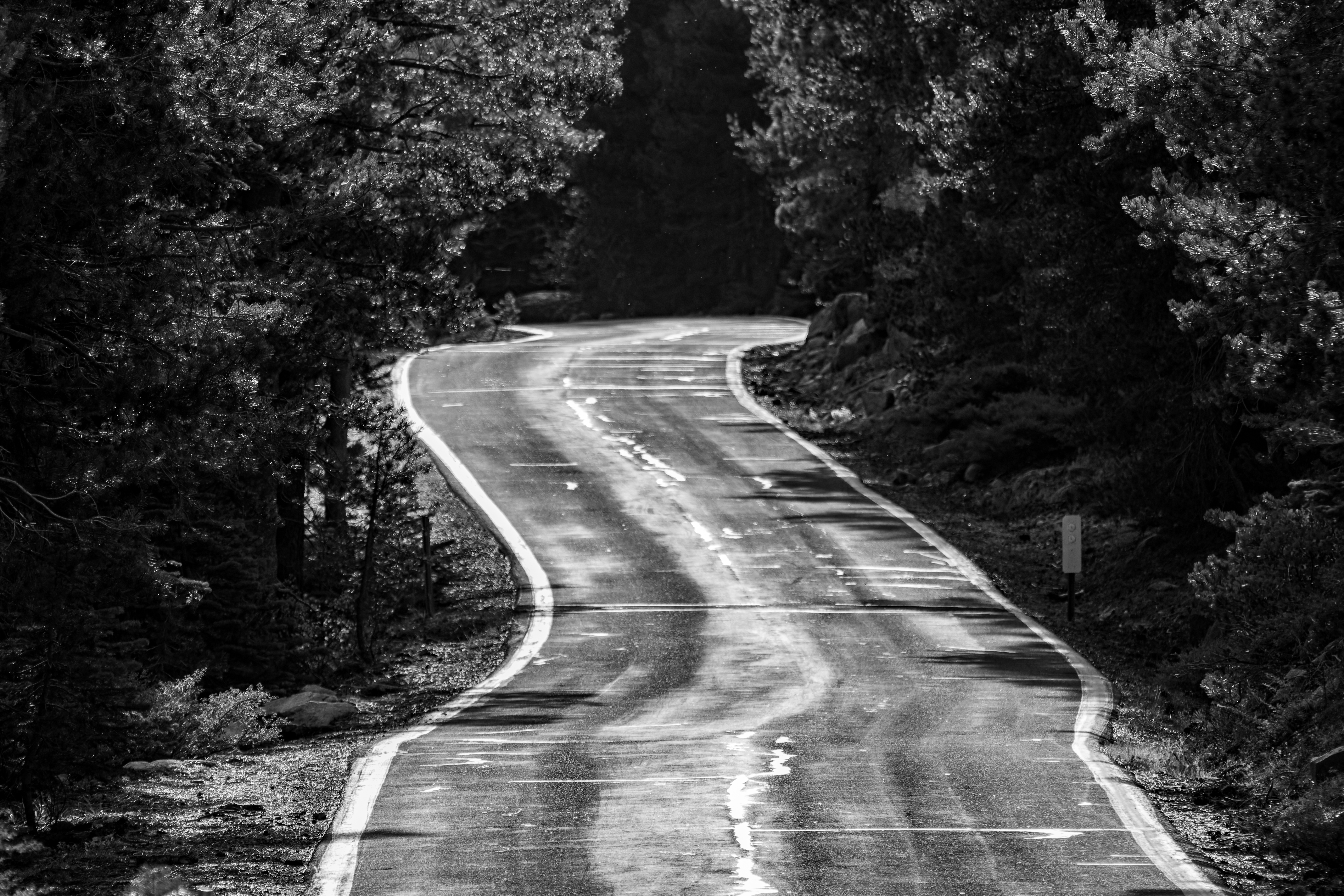
highway 4 is probably the steepest, twisted and challenging to drive section. Here
the road has less than two lanes without a dividing line. It has very steep grad
sections with blind corners and switchbacks.
Drive slowly
keeping a low gear.
No matter if
you are driving west (going up) or driving east (descending) drive slowly and
expect oncoming cars and let them to pass safely.


When you start
to see Noble Canyon view on your left drive slowly and once you are approaching
the first hairpin left turn look to the right and find a safe parking spot.
This is
probably the best viewing location along this section of the road.
If you are
driving east to west this viewpoint is exactly 1.4 miles after the entrance to Silver
Creek Campground.


The East Fork Carson River:
On the most eastern
side of highway 4 it is following the East Fork Carson River that is the
largest tributary of the Carson River.
Here the narrow
canyon is surrounded by high exposed mountains on both sides. The road that following
the winding river is not steep in this section and many people park on the roadsides
and walk to the river for fishing.
Highway 4
officially ends/start at the junction with highway 89, leading to Markleeville (4.8
miles to the north) or to Monitor Pass (southeast).
Although not
officially located on highway 4 the following location will probably be part of
your road-trip destinations.
Markleeville:
Markleeville is
a small town located near the East Fork Carson River in Alpine County. In its
location and vibe Markleeville has small town Alpine appearance and for tourists,
it is manly use as a rest stop on their California road-trip.


Grover Hot Springs State Park:
This state park
main attraction are the natural hot springs.
Due to damage from the fire the hot springs pool
complex will be closed until further notice.
We did not
visit here, for more information visit the park website:
https://www.parks.ca.gov/?page_id=508

Highway 89 and Monitor Pass:
If you want to drive
to highway 395 south, you need to cross the high Monitor Pass (8,314 ft) road
on highway 89. Monitor Pass crosses this unnamed ridge between tributaries of
the East Fork of the Carson River.
This road section
is only 17.5 miles long from the junction with highway 4 in the west side to highway
395 near Topaz Lake at the east side.


Interesting datapoint
about this road is that this highway was completed only in the early 1950s.
Monitor Pass is
subject to winter closure due to snow accumulation, and it is may be closed to traffic
between late November and early April.
The road climbs
the exposed reddish color mountains, without trees the views are open. From the
top of the pass and in many places along the drive you can enjoy the breathtaking
scenery to the valleys east of you and west to the high Sierra mountains.
East of the pass
summit the view opens up to the below valleys and road several switchbacks to
overcome the steep mountains slopes.
During fall
month mid-late October, the large grove of aspen trees that are growing along
the road near the pass are turning their color into bright yellow.
At the pass
check if you can drive up to Leviathan Peak.


Summery:
This is all
what I had to share with you about my experiences from Ebbetts Pass National
Scenic Byway (highway 4) road-trip.
This is one of
the most intimate and less traveled High Sierra crossing routes, but it enables
a perfect road trip destination for one day or multi day vacation destination.


www:
http://scenic4.org/
https://scenic4.org/ebbetts-pass-scenic-byway-map/


Fall Colors in California - Trip to Eastern Sierra
California State Highway 108
Where? : State Route 4 start
at the west from Interstate 80 in the San Francisco Bay Area to the east where
it connect to State Route 89 in the Sierra Nevada, this is 190 mile long road.
in this blog I will describe only the eastern section of the highway, starting
at Arnold when it climbs and cross the Sierra Nevada Mountain range.
Google Map Link

When? : This road is
closed at winter after the winter major first snowstorm and it open again late
spring (~May). Some road sections at the west (east of Arnold) are plowed allowing
cars to get to snow parks.
Check for road
conditions before you are heading to your road-trip.

Due note 1: There are practically
endless outdoor destination in this vast, remote area, the northern section of Stanislaus
National Forest protects and manage this region.
I had only few
visits in this area, so I can provide information only on things I did.
Due note 2: This road is narrow,
and winding, single lane in sections, and it is not recommended for tracks RVs
or bus.
Due note 3: Up to Bear
valley you are in Calaveras County and from there driving east you are getting
into Alpine County. It is interesting to know that as of the 2020 Census, the
population in this county was 1,204 people, making it California's least
populous county. The county largest community is Markleeville.
Due note 4: The road on
the west side of the Sierra follows the North Fork Stanislaus River and there
are many lakes, hikes, and campgrounds to find in this remote area.

Driving Warning:
Through the high
mountains section, this road is not suitable for large trucks, buses, or RVs!
It is relatively steep and, in some sections, even single-track, with no center dividing line. In the eastern sections of the highway there are tight switchbacks with limited visibility and cliff side road.
My thoughts: I only visit this
road two times, cross the Sierra east to west. This is probably the less travel
road that crosses the Sierra so you will see less people here. we mainly
stopped along the highway for viewpoints and to see the lakes but there are a
lot more things to do here… next time….

The Road Trip:
Road Trip Proposal:
The first time
we came here was to visit Calaveras Big Trees State Park we drove from Angels
Camp up to the park and after our visit we went back.
The second time
was as part of late fall (Oct.) long road-trip from the bay area, we were looking
for aspen trees fall colors viewing.
We started our
trip at Hope Valley (highway 88) and then drove to Markleeville for lunch break
at the local pub & restaurant. From Markleeville we drove on highway 4 up
the pass and continue west all the way to San Francisco Bay Area.
This is a long drive
for one day but the landscape and the views along the drive make it worth.
This ~430 miles
loop drive is the following: bay areaà highway 88 and Hope Valley à highway 89 à Markleeville à Highway 4 à cross Ebbetts Pass to the west à back home.

In the
following sections I will describe the attractions along highway 4 (things we
did or stop at).
I will list the
locations describing the route from west to east, even though we did our drive here
from east to west.
Calaveras Big Trees State Park:
Established in
1931, Calaveras Big Trees State Park preserves two groves of giant sequoias, in
addition to the giant trees reaching up to 250 feet tall, you will find here
many forest trails and the Stanislaus River.

The largest
tree in the park located in the South Grove, this is Louis Agassiz tree,
reaching well over 250 feet in height and 25 feet in diameter.
As part of your
road trip, you can do a short 2 hours visit in the park, exploring the North
Grove or dedicate a full day to explore the South Grove and the park trails.
Link to my Blog
describing my park visit: Calaveras Big Trees State Park.

The park entrance
is located just off highway 4, right east of the town of Arnold.
For more
information visit the park website:
http://parks.ca.gov/?page_id=551

Lake Alpine:
The Lake Alpine
reservoir (elevation of 7,300 feet) located within a granite basin surrounded
by pine forest; drive east of the community of Bear Valley on State Highway 4. The
lake is the central attraction of the Calaveras Ranger District.


Summer visitors
enjoy swimming, boating, hiking, camping, fishing, and many other outdoor
activities.
In winter, the
lake becomes part of the Lake Alpine SNO-PARK.
There are many campgrounds
around the lake, but you need to make advance reservation: https://www.recreation.gov/
Cape Horn Vista Point Picnic Table:
If you will
drive from Pine Marten Campground entrance exactly 2.1 miles east on highway 4 you
will find a small unmarked entrance to the right, where the road bend to the
left. Drive slow so you will not miss it. This is a very short entrance and you
can find here one picnic table.
If the weather
is nice and it is not cloudy, and you did not already rest at the lake this is
probably the perfect location for a lunch break.
The view from
this high location is amazing, you can see for miles to the east all the way to
the high mountain ranges in this area.
Be careful when
you are getting into this location and when you are coming back into the
highway.
If you are
driving west the table is visible but you will need to cut the road to the
other side so, do this carefully.


Mosquito Lakes and Pacific Grade
Summit:
This is
probably one of the most photogenic locations I saw in a long time, a small pond with two old wooden houses reflecting by the calm water and surrounding
by pine trees.
I hope that the
pictures deliver it beauty…


Mosquito Lakes
is more likely can be described as 2 ponds rather than lakes.
Here you can
find the Mosquito Lakes Campground and right after (when driving east) you will
bend right, look for parking spot at this place. You can find both on the right
and on the left side of the road.
There is a large
house is the land separating the 2 ponds and you can find on the eastern pond
another 2 small houses.
We did not stop
here for long time, took few pictures, and keep moving on, right after the east
pond you are passing Grade Summit at 8,050 ft.

Ebbetts Pass. And Kinney Reservoir:
Ebbetts Pass at
elevation of 8,730 ft is one of the least traveled passes in the Sierra Nevada crossing
the mountains west to east. This is probably the first Sierra pass crossed by a
non-Native American, when Jedediah Smith crossed the Sierra in spring, 1827.


When driving it
west to east you will almost not feel the pass itself but then you will reach the
steep descent on the east side of the pass.
When driving
west, after short drive you will see Kinney Reservoir on your left, there is a
small place to park here, near the lake dam.
From the Kinney
Reservoir you can hike up to Upper Kinney Lake via a 1.2-mile-long trail (one
way), excellent destination for fishing or for hiking and exploring this area.


After driving
east of Kinney Reservoir, the road start descending gradually along Kinney creek but after 1.5 mile you will get
into a steeper section. Now you are driving into Noble Canyon, this section of
highway 4 is probably the steepest, twisted and challenging to drive section. Here
the road has less than two lanes without a dividing line. It has very steep grad
sections with blind corners and switchbacks.
Drive slowly
keeping a low gear.
No matter if
you are driving west (going up) or driving east (descending) drive slowly and
expect oncoming cars and let them to pass safely.


When you start
to see Noble Canyon view on your left drive slowly and once you are approaching
the first hairpin left turn look to the right and find a safe parking spot.
This is
probably the best viewing location along this section of the road.
If you are
driving east to west this viewpoint is exactly 1.4 miles after the entrance to Silver
Creek Campground.


The East Fork Carson River:
On the most eastern
side of highway 4 it is following the East Fork Carson River that is the
largest tributary of the Carson River.
Here the narrow
canyon is surrounded by high exposed mountains on both sides. The road that following
the winding river is not steep in this section and many people park on the roadsides
and walk to the river for fishing.

Highway 4
officially ends/start at the junction with highway 89, leading to Markleeville (4.8
miles to the north) or to Monitor Pass (southeast).
Although not
officially located on highway 4 the following location will probably be part of
your road-trip destinations.
Markleeville:
Markleeville is
a small town located near the East Fork Carson River in Alpine County. In its
location and vibe Markleeville has small town Alpine appearance and for tourists,
it is manly use as a rest stop on their California road-trip.
You can find here few places to eat, we went to “Cutthroat Brewing Company and Restaurant”, and we also saw across the road the “Out West Cafe & Dollface Cheesecakes” and the “Stonefly” coffee shops. you can also find here a Gas station and general stores.


Grover Hot Springs State Park:
This state park
main attraction are the natural hot springs.
On July 2021, the Tamarack Fire burned through Grover Hot Springs SP and destroyed multiple state park housing structures.
Due to damage from the fire the hot springs pool
complex will be closed until further notice.
We did not
visit here, for more information visit the park website:
https://www.parks.ca.gov/?page_id=508

Highway 89 and Monitor Pass:
If you want to drive
to highway 395 south, you need to cross the high Monitor Pass (8,314 ft) road
on highway 89. Monitor Pass crosses this unnamed ridge between tributaries of
the East Fork of the Carson River.
This road section
is only 17.5 miles long from the junction with highway 4 in the west side to highway
395 near Topaz Lake at the east side.


Interesting datapoint
about this road is that this highway was completed only in the early 1950s.
Monitor Pass is
subject to winter closure due to snow accumulation, and it is may be closed to traffic
between late November and early April.

The road climbs
the exposed reddish color mountains, without trees the views are open. From the
top of the pass and in many places along the drive you can enjoy the breathtaking
scenery to the valleys east of you and west to the high Sierra mountains.
East of the pass
summit the view opens up to the below valleys and road several switchbacks to
overcome the steep mountains slopes.
During fall
month mid-late October, the large grove of aspen trees that are growing along
the road near the pass are turning their color into bright yellow.
At the pass
check if you can drive up to Leviathan Peak.


Summery:
This is all
what I had to share with you about my experiences from Ebbetts Pass National
Scenic Byway (highway 4) road-trip.
This is one of
the most intimate and less traveled High Sierra crossing routes, but it enables
a perfect road trip destination for one day or multi day vacation destination.


www:
http://scenic4.org/
https://scenic4.org/ebbetts-pass-scenic-byway-map/
Additional Pictures:


Comments
Post a Comment