
Introduction:
What? : This is
probably one of the best hikes in Yosemite, you will start your hike at the valley
east south section and hike up the year-round flowing Merced River, from the
misty base of Vernal Falls (317ft tall) you will hike up to the top of Nevada
Fall (594ft tall). On your way back you will hike section of the John Muir
Trail. If you are short in time or afraid that the longer loop is too much for
you, you can do shorter sections of this trail.


More Yosemite Related Blogs:
- Yosemite National Park – How to plan your One-Day visit
- Yosemite National Park - Bear Pictures
- Yosemite NP – Hike to Half Dome Diving Board
Where? : The trailhead
is located near Happy Isles shuttle station (#16), cross the bridge to the
other side of the Merced River and you will see Mist Trail and John Muir
Trailhead on your right.
For a Beautiful Nature Prints - Visit my Etsy Store
Google Map Link
Parking: For the one coming
with cars, the nearest parking lot is Yosemite Valley Trailhead Parking (will
add you overall of 1 mile to your hike distance). This parking lost is getting
full very early in the morning, you can also park at large Curry Village
Parking Lots (will add you overall of 1.5 mile to your hike distance).
Google Map Link


When? : The best times
to visit this trail are the month of spring and early summer when the snow is melting,
and river flow is at it peak. This river is flowing year-round so you will always
see the waterfalls.
Due note 1: This trail is
one of the most traveled in Yosemite National Park.
Due note 1: The longer
hike all the way to the top of Nevada Fall is amazing hike, but I do not I recommend
it for people that are short on time and want to visit Yosemite in one day
visit, you may hike only to the bridge and have time to explore other things in
the valley.
Due note 2: If you only
have time for one long day hike while in Yosemite the Mist Trail is the hike
for you, you can also hike shorter sections of this hike to fit your schedule
and hiking abilities.

Dune Note 3: Hiking the
full 7-miles loop with 2000 ft of elevation gain is a strenuous, 5-6 hours hike
and my not fit everybody. Hiking to the base of Vernal Falls is a an option that may fit more
people.
Due note 4: Bring enough water
with you for the hike, drinking water is available at the shuttle stop near the
trailhead and near the wooden bridge. There are Restrooms at several locations
along this hike (wooden bridge, Vernal Fall the top of the climb near Nevada
Falls).

My thoughts: This is
probably the best half day hike you can do in Yosemite. I did this hike many
times, alone, with friends and family and with small kids and we always enjoy
it.
I hiked here 2
times at winter after snowstorm when the trail was covered with ice and deep snow,
it was unique experience.


The Hike:
This is my all-time
preferred hike in the park.
It combines, canyon
walk, seeing 2 large waterer falls, grand vista view from the top of Nevada
falls as well as good half day hiking exercise.
This is one of
the most popular hikes in the park, do not expect to be the only one her. It is
busy trail even from early morning (for people that are hiking to Half Dome), I
found that late afternoon it has fewer other hikers.
You have 3 options to hike here so
can be flexible with your planned time and hike difficulties you want to do.
- Vernal Fall Footbridge: 1.6 miles
round trip, 400 ft elevation gain, Moderate, 1-1.5 hours
- Top of Vernal Fall: 2.4 miles round
trip (via Mist Trail), 1000 ft elevation gain, Strenuous, 3 hours.
- Top of Nevada Fall: 7 miles loop
trail (via Mist and John Muir Trails), 2000 ft elevation gain, Strenuous, 5-6
hours.


Note: To all the
above hikes you need to add 1 mile to the nearest parking lot, if you are using
the valley shuttle than the bus stop is located near the trailhead.
Note: From the
parking lots there is a trail parallel to the road that will lead you to the
trailhead.

Vernal Fall Footbridge:
You will start
your hike at Happy Isles shuttle station, cross the road bridge to the other
side of the Merced River and turn right into the trail.
This section of
the hike is on paved trail.
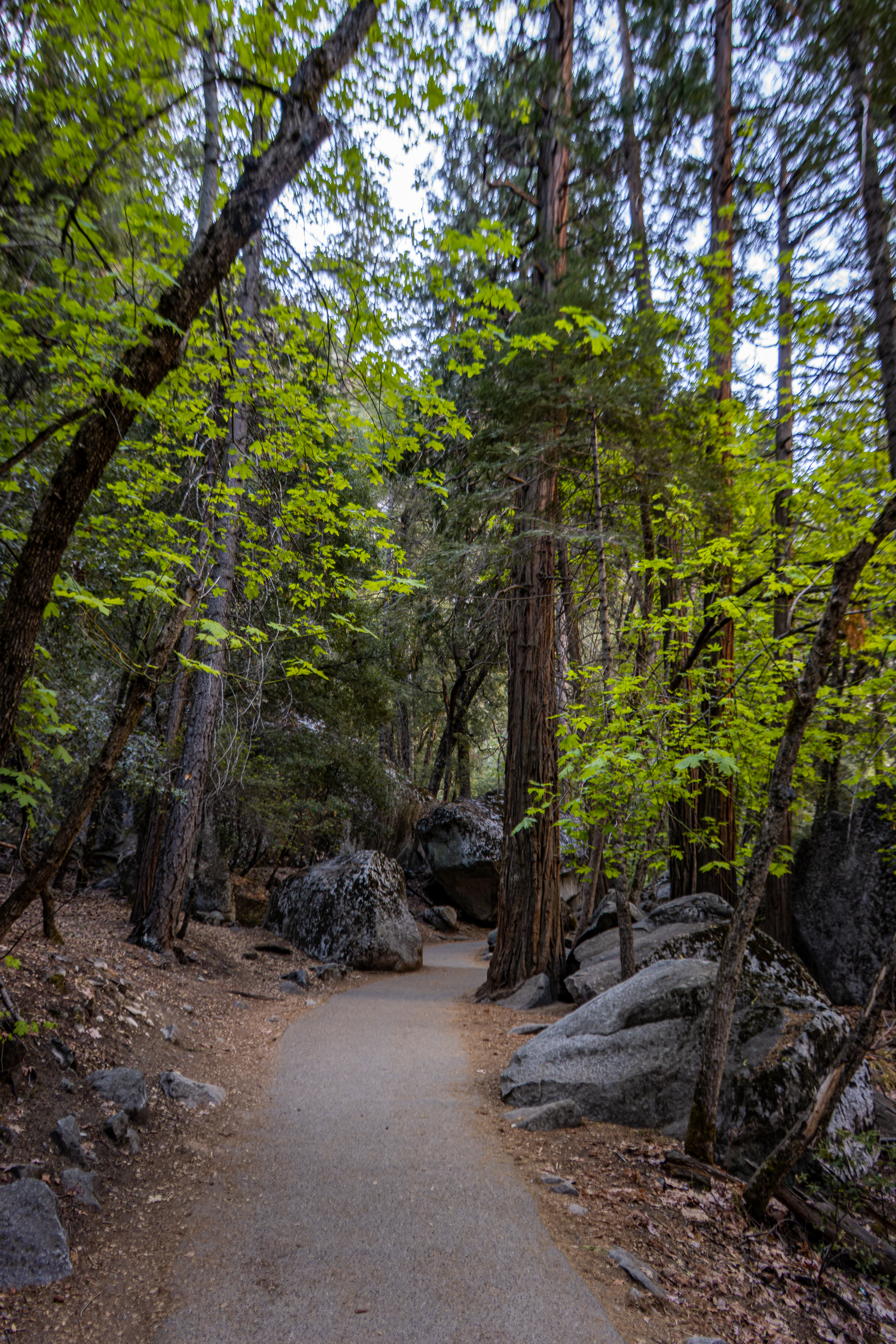
The trail starts
moderately in the canyon floor and soon after the large rock boulders section
the trail leaves the river level and start to climb. Some sections can be steep
grade, make stops to recover your breath.


Most of the
trail is within the forest and is protected from the sun but there are few
openings where you can enjoy the canyon and the river view below.
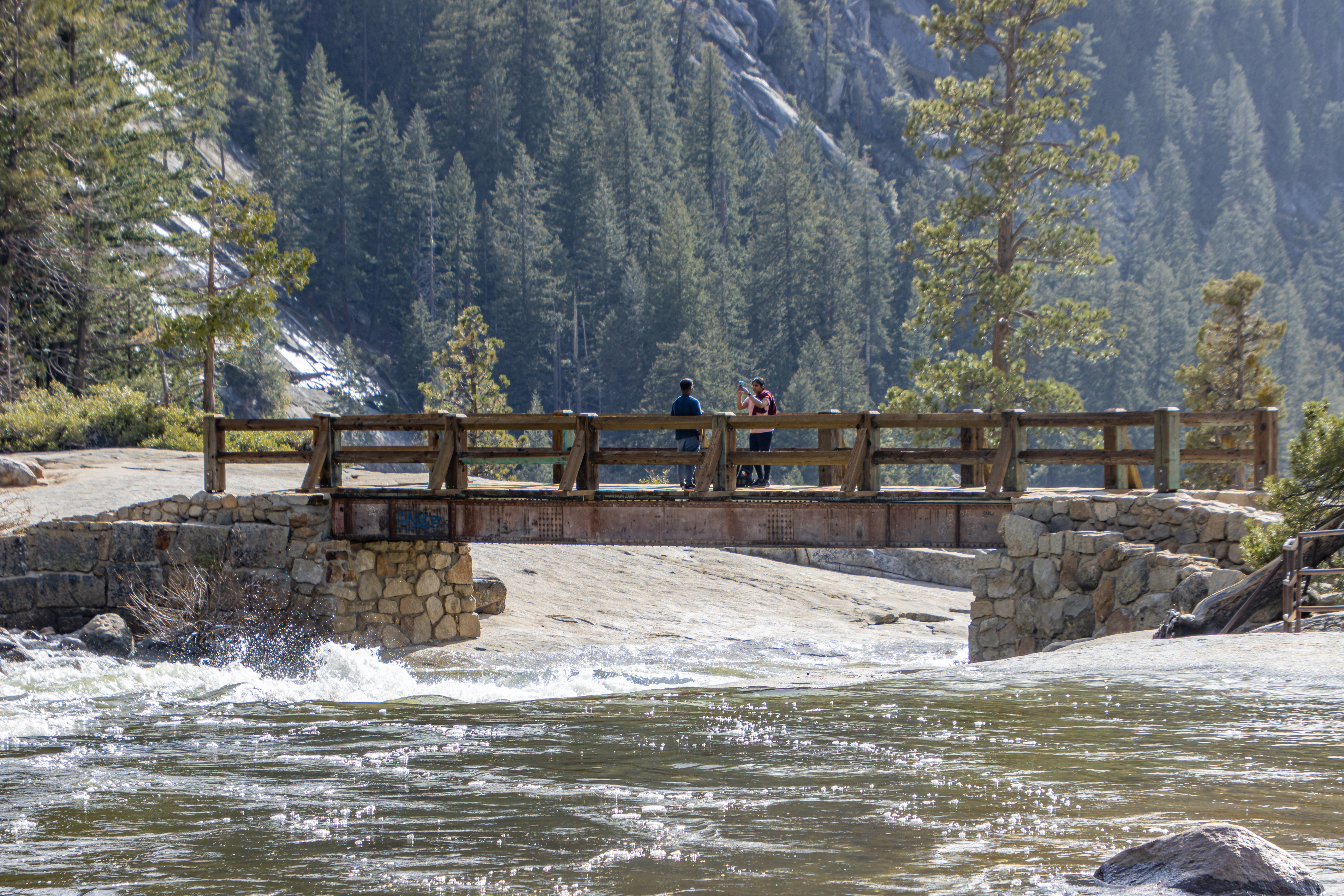
After 0.8 miles
you will reach the large wooden bridge that is crossing the Merced River.
From the wooden
bridge you will see the cascade of the Merced River flowing in the canyon below
and you can also catch a glimpse of Vernal Falls top section up the canyon.
This is your
first “decision point”, you can hike back to your starting point or keep hiking
up the trail.
Vernal Fall:
Even if you do
not want to climb tall the way o the top of Vernal Falls, I highly recommend keep
hiking for another 0.4 mile (not a steep climb) to the base of Vernal Falls,
you do not need to climb to it top but enjoy it from below.
At the end of
this trail section a steep granite stairway of over 600 steps will take you
around the rock and you will see the waterfall.

This section of
the trail at the base of Vernal Falls gave this trail its name “Mist Trail”,
here the wide river opening, and the narrow canyon below the waterfall creates
a mist rain.


Plan to get wet
here, especially during spring and early summer when the river water level is
high. Some hikers bring with them light raincoat but most just get wet and dry themselves
at the top of the waterfall. It is fun to get wet here and the splashes of the
mist will cool you in a hot summer day.
There are many
viewing points along this steep climb section to enjoy the view and the mist of
this impressive waterfall.

Note: Even at summer
if you are coming in the morning this trail section is in the shadows of the
mountains and it can be cold when you are getting wet.
Note: During late
summer & fall, when the water level is not high, and the Vernal waterfall
is not raging, you can walk over the boulders down to the base of the waterfall.
Be careful not to fall.


If you hiked up
to this section, you can “save” the steep stairs section leading to the top of
the Vernal waterfall and from here hike back down (1.2 mile to the hike starting
point).
If you have
time, I do recommend hiking up to the waterfall level, you can take as many
rests stops as you want/need along the short way up.


From the section
below the waterfall the trail climbs steeply on rock steps and just before the
last section it turns to the right and following a narrow path in the cliff.
This short narrow
section, protected by metal rails can be packed with people where hikers that
are climbing up and hikers going down need to pass each other.

Once you cross
this short section you will arrive at the opening above the Vernal waterfall.
Here you can
rest, get dry and enjoy the sun.
Walk to the end
of the rock section and watch the waterfall from the top down, impressive to
see how to river fall over the cliff.


Note: Do not cross
the rails!
Note: Swimming in
the pools here is not allowed and is very dangerous.
After enjoying the
view and resting in the open area or in the shaded forest near the river Emerald
Pool section you need to decide what to do:
·
You can hike back the same way you came
up
·
You can hike back through a loop
trail that connect to the John Muir Trail
·
You can climb up all the way to the
top of Nevada falls.
Hike back down through a loop
trail:
There is an
option not to hike back the exact same way you went up. This is a longer way
with some additional climb, but I do recommend taking it because it provides high
viewpoints on Nevada falls, the Merced canyon and the “back” of Half Dome.

From the head of
Vernal waterfall keep hiking for a short distance up the trail and soon you
will see a trail junction (before reaching the bridge). Take right here and
climb 0.8 miles up to Clark Point junction with John Muir Trail.

Look back and you
will enjoy the panorama view of the canyon, Nevada waterfall, and the 3 mountains:
Half Dome, Mt Broderick, and Liberty Cap towering above the canyon.
From this trail
junction hike down on John Muir Trail, after 1.1 miles of descending sharply
into the canyon in a series of switchbacks and you will reach Mist trail, just
before the wooden bridge.
From here keep
hiking all the way down to the trailhead.
From Vernal Falls climb up to Nevada
falls:
From the head of
Vernal waterfall keep hiking for a short distance up the trail and soon you
will see a trail junction, keep hiking left and you will reach a wooden bridge.

Enjoy the raging
Merced River passing through this narrow section into the waterfall.
Keep hiking up
and after 0.2 miles you will reach an open in the woods just right of the
trail.
Walk to this opening,
from here you can see the Nevada falls.


From this point
the trail turn left and start a steep climbing section.
This is a 0.6-mile
steep section where the trail climbs the cliff on the left side of Nevada Falls.
At some point a series of stone staircase find its way on the cliffside following
a series of switchbacks all the way into a side narrow creek and to the upper level.
This section is
the most difficult section of our hike.

At the top of
the climb, you will reach a trail junction, here you can also find restrooms.
From here, our
trail turns to the right, leading to the top of Nevada Falls, if you turn left
on John Muir Trail you will hike up into Little Yosemite Valley, Half Dome,
Cloud Rest, and deep into the Yosemite wilderness area.
After turning
right to Nevada Falls you will soon reach the waterfall area, cross the bridge
to the other side and enjoy the view.
Be careful not
to get too close to the cliff there is no protection rails here.
Do not swim in
the river.


There is a
small over-the-top observation platform on the right (north) side of the
waterfall. Before crossing the bridge walk on the rock to your right and finds the
path that is leading to the lower area, here there are metal rails that protect
from falling, be careful.


After enjoying
the view from the top of Nevada Falls you can hike down the same way you went
up or you can choose to take the alternate route down along the John Muir Trail.
I highly recommend taking this option.
From this trail
you will see a great views of Nevada Falls and Half Dome, Mt Broderick, and Liberty
Cap towering from above.

John Muir Trail
starts at the flat section, going into the wood, soon you will arrive to the
cliff hanging section where the trail is cutting itself into the cliff rock.


At this short
section there is small waterfall dripping all over the trail. This is the
reason why this section of the trail gets close during winter, ice cover everything.
From this open
section you have a side view of the Nevada waterfall and the towering mountains
above.

After hiking 0.4
miles from the Nevada waterfall, you will reach a trail junction, keep hiking
down (right) on John Muir Trail. The trail heading left and up, called Panorama
Trail and it can lead to lllilouette Creek and waterfall and from there up to
Glacier Point.
After one mile
down on John Muir Trail, you will reach Clark Point junction. Here you need to
turn left, keep walking down on John Muir Trail (turning right here will take
you to the top of Vernal waterfall). This point is another viewpoint on the
landscape.


Additional 1.1
miles of descending sharply into the canyon in a series of switchbacks and you
will reach Mist trail, just before the wooden bridge.
From here keep
hiking all the way down to the trailhead.
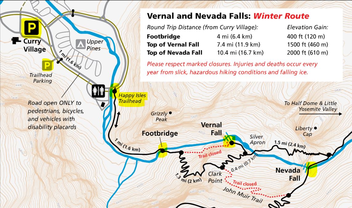
Winter Hiking:
If you want to
visit here during the winter this is possible, but some sections of the trails
are close, and you will need to use the winter rout.
I did this hike
twice when it was very called, icy and the trail was covered in deep snow, it
was challenging and fun and the snow-covered landscape was amazing.


When it is ice
and snowy it is highly recommended to walk with simple shoes crampon (walking
spikes for shoes) that will help you preventing slipping on the ice, walking
sticks can also help your stabilization.
I do not think
that you need to have large snowshoes, assume that other hikers before you already
paved the way in the fresh snow after the snowstorm. If you are the first hiker
on the trail after a snowstorm you probably need them.


Those restrictions
and trail limitations are not only in effective when it is snowing, this is because
of the mist, rain, and waterfalls as well as cliff sections the trail can be completely
covered with slippery ice when it is cold during night and early morning.
Do not take the restrictions or hiking conditions lightly, follow the rules and stay safe.
Such icy conditions are not only for the higher elevation section of the trail but can also happened at the lower first steep section of the trail leading to the wooden bridge.


To reach the top of Vernal Fall:
After the wooden bridge hike, the John Muir Trail to Clark Point, this 1-mile section can be covered with a deep snow, hopefully others already open the middle of the trail, paving the way in the deep snow. At Clark Point enjoy the view, here the trail forks out of John Muir Trail.


The right fork (John Muir Trail) will be gated shut, so follow the left fork downhill to reach the Mist Trail junction just a few minutes upstream of Vernal Fall. A left turn here brings you to the top of Vernal Fall, while a right turn follows the Mist Trail crossing a wooden trail all the way uphill to Nevada Fall.
For more up to date information visit this page:
https://www.nps.gov/yose/planyourvisit/vernalnevadawinter.htm

www:
https://www.nps.gov/yose/planyourvisit/vernalnevadatrail.htm
Additional Pictures from this Trail:


Comments
Post a Comment