Introduction:
What? :
Foothills Naturae Preserve Park is a large Palo Alto park that is open to the public. The park cover the hills at the south sections of Palo Alto and you can find here on top of many miles of hiking trails also large grassy field, lake, picnic sites, a
walk-in, tent-only campground, and a nature interpretive center. You can fish
in Boronda lake or just enjoy the trails.
Now, once the park is open to the public and it is not as crowded as it was (partly because of the 6$ entrance fee) I like my visit here, fun trails and nice view of the south-bay area.

Where? :
The Palo Alto
Park is in the eastern foothills of the Santa Cruz Mountains. The park is bordered
on most of its eastern boundary by Page Mill Road and from there is also the
park entrance. You can also hike to this park from Pearson-Arastradero Preserve.
When? :
The park is
open year-round. 8:00 AM – Sunset.

Due note 1: There is a car
entry fee of 6 $.
Due note 2: From 1969
until 2020, only residents or city employees of Palo Alto had lawful access to
it, because of lawsuit the park was opened to the general public on December
17, 2020.
Due note 3: The Orchard
Glen picnic area is a great place to have break, located in the middle of the
park with large trees that provide shad during hot summer months. Tables and
BBQ are first-come, first-served.
Due note 4: There are restrooms
and drinking water in several locations.
Due note 5: Dogs are not
permitted anywhere in Foothills Nature Preserve on weekends or city holidays.
Dogs are only permitted on weekdays and must be on a leash.
Due note 6: Bicycles are
allowed on paved roads only, and not on trails.
Due note 7: No
remote-control devices, like drones, allowed in the park.
Due note 8: Camping: Towle
Camp is a seasonal campground available for tent camping from May 1 to October
31.
Due note 9: The small Nature
Interpretive Center has some exhibits, and it is located near the large open
grassland in the middle of the park.
My thoughts:
This park was
close to Palo Alto residence for many years and once it got open to the public
it became extremely crowded during weekends, so I did not visit it.
I did few long
hikes crossing the park and walking to the mountain ridge.
Recently I visited
the park several times and find it less crowded and a fun place to visit, hike with
friends and later have a picnic. There are many trails’ options so you can
always “discover” a new trail.

The visit:
When visiting
the park, I recommend visiting the small Boronda Lake near the park entrance.
There are few parking spots on the road near the lake or you can park on the
way to Vista Hill.
Another recommended
point to visit is Vista Hill (elevation of 950ft) that provide open view north
down to Palo Alto.
There are many
options of hiking trails, which offer a variety of hiking experiences, from
easy walk along the small lake shore, mid-level hikes in the nearby hills to
longer hike crossing the park and climbing the Santa Cruz hills to the south.

Center Park Loop Hike, 5.5 miles
long hike:
This is my
favorite hike in the park and this loop can be modify and use other nearby
trails to create it shorter or longer.
With this hike
that start at the main park large open grassland you are passing through the
hills and going down into the main valley and can combine it with lake side
trail.
Link to
AllTrails map:

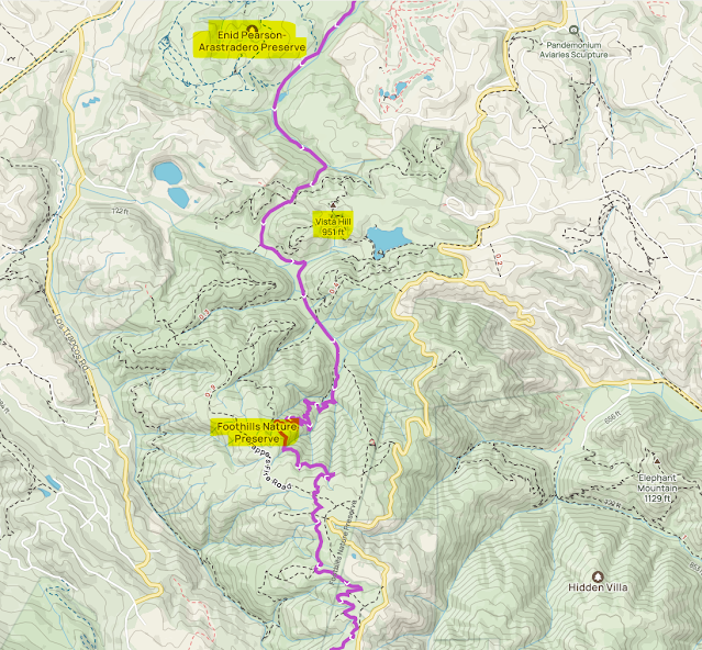
Longer hikes passing through the
park:
The park is
located between 2 other large open space parks: Pearson-Arastradero Preserve on
the north (lower hill section) and Los Trancos Open Space Preserve on its south
boarder (higher mountain ridge).
The
Bay-to-Ridge Trail runs through the park south-north.
Many times, I
hiked into the park from Pearson-Arastradero Preserve connecting trail climbing
up the hills to Los Trancos Open Space and from there to Black Mountain or to Skyline
Ridge Open Space Preserve.
Below are few
hiking options how to hike through the park:
Link to
AllTrails map:

www:
Map:
Additional Pictures:


Comments
Post a Comment