
Introduction:
What? : Just north of
San Francisco's Golden Gate is large, 6,300 acres, Mount Tamalpais State Park.
It has redwood groves and oak woodlands with a spectacular view from the
2,571-foot peak.
The panorama view
from the 2,571-foot Mount Tamalpais peak is breathtaking. On a clear day, you
can see the Farallon Islands out to sea, the Marin County hills, Mount Diablo,
San Francisco, and the hills and cities of the bay.


Where? : Located in
Marin County just north of Golden Gate National Recreation Area. The main park
road is Panoramic Highway, for us coming from San Francisco take the right fork
off highway 1 at the East Entrance (3.2 miles west of highway 101). The road climbs
the mountain slopes and then it is descending west to the ocean, it reconnecting
to highway 1 at Stinson Beach, just south of the town center (this is the park entry
point to the one going south on highway 1).
Google Map Link


When? : Year round, at
summer the deep gorge and the trees will protect you from the sun. Many trails leading
to the mountaintop, including the Old Railroad Grade Fire Road, do not have
shade and are exposed to sun.
Due note 1: Pantoll Ranger
Station and Park HQ, located at the junction of Panoramic Highway and Pantoll
Road, this is a good place to start your visit, getting information and pay for
parking fees.
Due note 2: As I understand
it you need to pay a day-fee for parking lots (i.e., you need to pay 10$).
Due note 3: On weekends
and holidays, a Golden Gate Transit bus runs from Stinson Beach up to Pantoll
Ranger Station and along the Panoramic Highway to Marin City.
Due note 4: At East Peak,
a small visitor center and recreated Gravity Car Barn are open as volunteer
staffing allows
Due note 5: Muir Woods
National Monument is surrounded by the state park, but it is a separate park
and govern by another entity (GG-NRA).
Due note 6: Marin Mt
Tamalpais Watershed District is a huge open space area adjacent to
the park from the north. Actually, most of the area north of Panoramic Road,
including Mt Tamalpais (exclude the road and the mountain top), the large open
space valleys and the lakes to the northwest are part of this unit (see map below).
You can combine several trails in both parks and have relatively long day hikes.
https://www.marinwater.org/sites/default/files/2020-09/Watershed%20Visitor%20Map.pdf


Due note 7: There are few
camping sites within the park, Bootjack or Steep Ravine are great for overnight
staying.
Due note 8: The Park is
open from 7am to sunset year-round. Dogs are not allowed on trails, on fire
roads or in undeveloped areas.
Due note 9: The sport of
mountain biking was invented on Mount Tamalpais in the 1970s and ‘80s. Bikers
can enjoy the Coast View and Dias Ridge multi-use trails as well as park fire
trails. Cyclists are not allowed on other single-track trails.

My thoughts: Mount
Tamalpais State Park and its surrounding open spaces provides endless opportunities
to hike and enjoy the outdoors; you can’t cover all what it has to offer in one
visit. I did several day trips & hikes at the park and enjoy it very much,
and still there are many sections of the park that I want visit.
The visit:
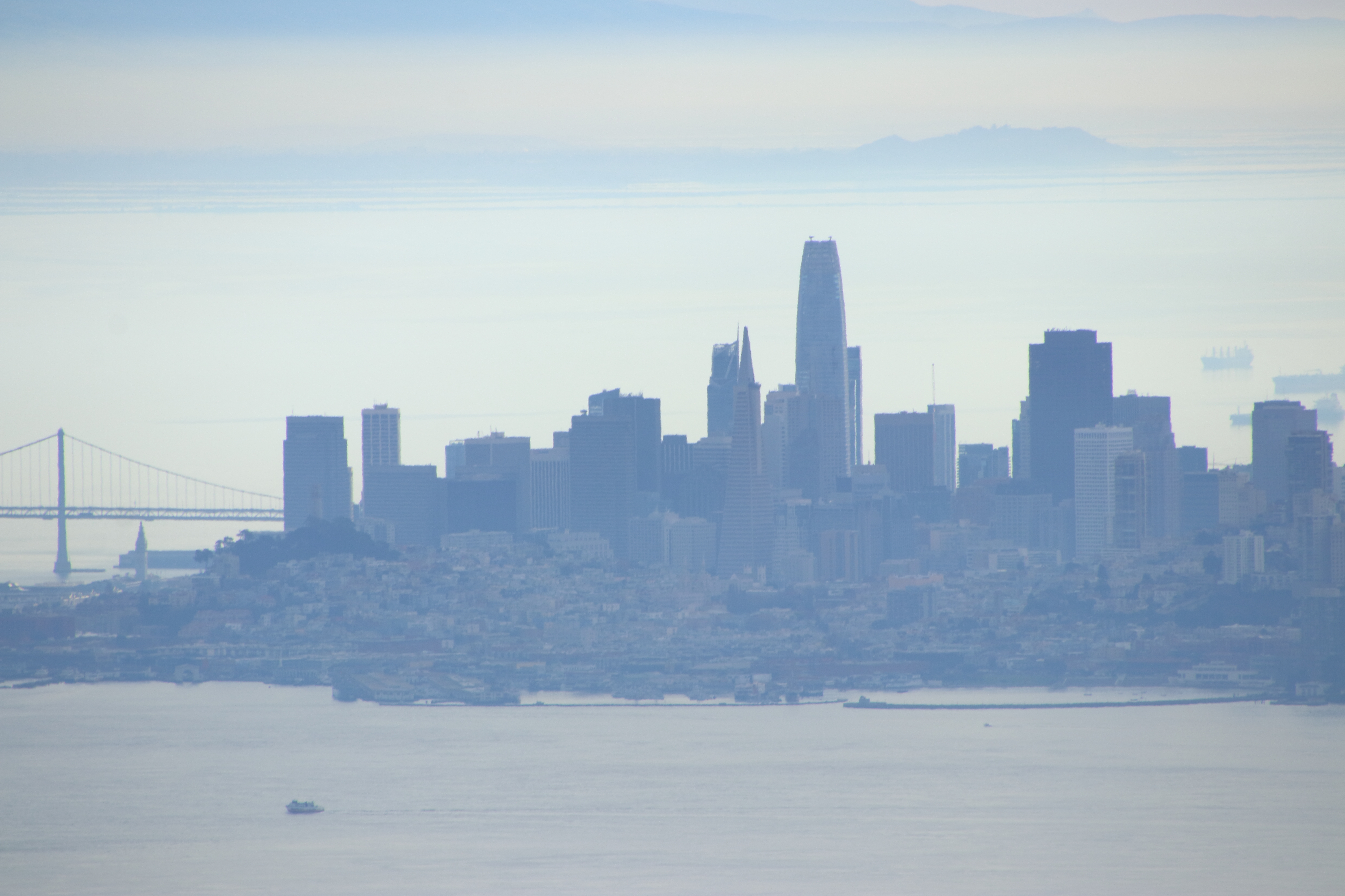
On a clear day,
when there is no fog, visitors can see from the Mount Tamalpais East Peak Fire
Lookout the Farallon Islands 25 miles out to sea, the Marin County hills, San
Francisco and the bay, hills and cities of the East Bay, and Mount Diablo.
Mount Tamalpais
Park contains mostly redwood and oak forests. The mountain itself covers around
25,000 acres and it has many miles of hiking/biking trails.

Muir Woods National Monument:
I can’t write
on Mount Tamalpais Park without mentioning Muir Woods National Monument.
This National
Monument is surrounded by the state park, but it is a separate park and govern
by another entity.
This is
probably the most beautiful redwood grove near San Francisco, especially now
when Big Basin State Park had fire at the summer of 2020.

History – The Crookedest Railroad:
At the early
1900s Mount Tamalpais had on its southern slope what was probably the world’s
crookedest railroad ascend. Built in 1896, the Mill Valley and Mount Tamalpais
Scenic Railroad negotiated 281 curves on its eight-mile way to the summit. From
the summit a Gravity Car, with a brake’s operator only, took the 30 passengers card
all the way down. Riders came to try out this new branch line, which was known
as the “longest roller coaster ride in the world.”
After massive wildfire
that burned all the buildings and facilities at the mountain slops the Scenic
Railroad stop to operate in the 1930s and the rails where removed. Today you
can hike the Old Railroad Grade Trail.

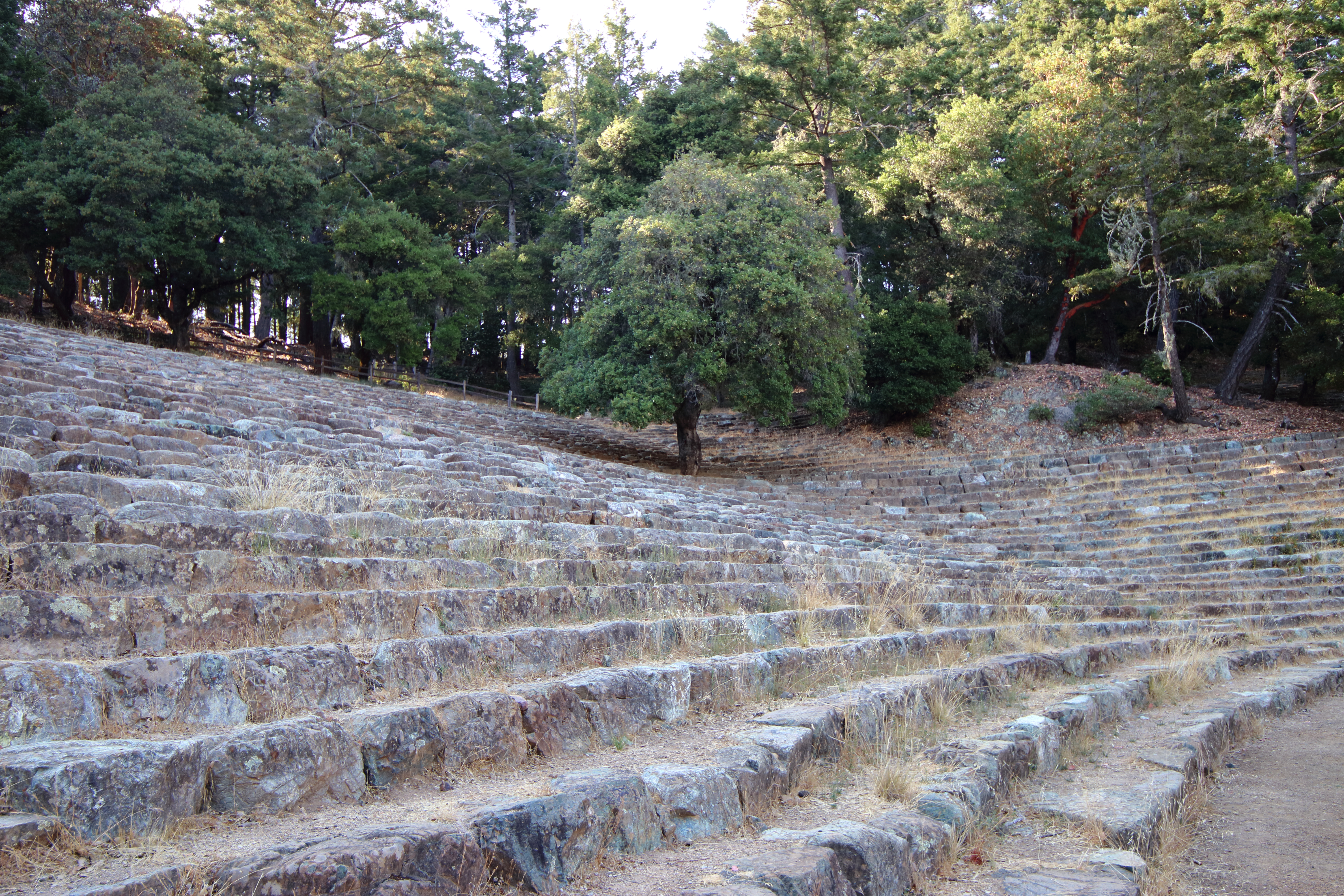
Mountain Theater:
The 3,750-seat Mountain
Theater, officially named the Cushing Memorial Amphitheatre, was built of
natural stone in the 1930s. it still has live shows once a year.
Hikes:
You probably need
to plan your park day visit in advance, there are few options, and you can’t do
it all in one day.
In any case, do
plan to drive up to mount Tamalpais highest point at the end of your visit and
enjoy the view from the top.

My recommended options:
·
Visit Muir Woods National Monument,
a must visit redwood forest, and then drive to Mount Tamalpais.
·
Visit at the west side of the park and
hike one of the following options: Cataract
Trail, Steep Ravine Trail Loop.
·
Climb Mount Tamalpais, you can
start at Throckmorton Fire Station or from Pantoll Ranger Station Park HQ
·
Long (~17 miles) loop hike that climbs
the mountain top from Panorama Highway, from there hike down to the valley and
lakes that are located north of the mountain ridge (Marin Mt Tamalpais
Watershed District). Climb back the ridge using Cataract Trail and complete the
loop hiking to your car.
·
Hike the south side of the park (Dias
Ridge Trail), still on my to-do list…
At my hike descriptions
below I will not distinguish between trails that are in the park boundaries to hikes
that are practically in Marin Mt Tamalpais Watershed District, from my view all
this area is one big hiking playground.
East Peak Fire Lookout:
This is
probably the easiest but a must do hike, the view is amazing.
Drive all the
way to the highest point and park your car at the parking lot near the small
visitor center (not sure if there is a lot to see here).


I will start my
walk at Verna Dunshee Trail, a flat paved trail that circle the mountain top, I
recommend doing it counterclockwise. Start near the Gravity Car Barn and learn
about the local train activity, keep walking the trail and you will start circling
the mountain. After the east section you will reach the southeast viewing point
to Richardson Bay, Sausalito, San Francisco, and the Bay bridge 14 miles to the
south.

After enjoying
the view keep walking and soon you will be back at your starting point. Overall,
this is 0.7-mile easy hike with rewording view.
From here take Plank
Walk Trail that will take you to the fire lookup at the top of the mountain. Here
you can enjoy the 360 views, from the ocean to Sonoma, Marin County and south
to San Francisco. The Fire lookout itself is close.
This 0.5-mile trail
is not difficult, and I highly recommend doing it even if you did the lower
loop.
Panoramic Highway to East Peak:
Start your hike
at Panoramic Highway small parking near Throckmorton Fire Station (https://goo.gl/maps/YjqdyKPhH2he3qpK6).
Overall hike is
5.8-mile hike with 1600 feet elevation.


From the
parking lot near the road take the Gravity Card Fire Road trail that gradually
climb the mountain slopes, after 1.3 mile you will reach Hoo-Koo-E-Koo Fire Road
and Vic Haun Trail. Leave the Gravity Card trail and turn into one of them,
they will both connect to Temelpa Trail. There you will turn right and go up
the mountain using Temelpa Trail. The climb up at this section is much steeper (including
switchback sections) and after hiking 1.5 mile you will reach the summit Verna
Dunshee paved Trail. Overall, from the starting point below to this point it is
3.1-mile hike.

Turn left and go
to the observation point and enjoy the view all the way to San Francisco.
From here visit
the Fire lookout at the top of the mountain (read the East Peak Fire Lookout
section above).
Once you
decided to go down, go to the parking lot and at the lower (south) road find
the entrance to Upper Fern Creek Trail.
Start to hike
down in the creek, at this section the narrow trail is finding it way down in
the dense vegetation. After 0.75-mile you will reach the Old Railroad Grade
Trail. Turn left and after 0.35-mile you will reach the junction with Hogdack
Fire Rd. turn right and hike all the way down to the fire station below and
from there to your car.
The trail down
is 1.8-mile long.

Pantoll Ranger Station Park HQ to East
Peak:
Park your car
at Pantoll Ranger Station (https://goo.gl/maps/4LcU44pV5xU2j61ZA) or at the nearby
Bootjack Campground parking lot (https://goo.gl/maps/4BQF1PG3z8qA4EY18).

From both
starting points take the Old Stage Road that is climbing gradually the mountain slop's (if you started at Bootjack take the short Bootjack Trail up that will
connect you to the main trail).
After two miles of moderate climbing from Pantoll Ranger Station you will reach West Point Inn, an active lodge with cabin for rent.


After you done with resting and enjoying the
view to the south keep hiking, here you need to find the Old Railroad Grade
Trail that is going up on the back side of the lodge (do not take by mistake
the trails that are going down).
Keep hiking up
the trail and after additional 1.4-mile you will reach the road leading the
top, turn right on the road and hike (0.3-mile) to the small visitor center.
From here visit
the Fire lookout at the top of the mountain (read the East Peak Fire Lookout
section above).


You can go back
down to your car on the same trail or take another trail; go to the parking lot
and at the lower (south) road find the entrance to Upper Fern Creek Trail.
Start to hike
down in the creek, at this section the narrow trail is finding its way down in
the dense vegetation. After 0.75-mile you will reach the Old Railroad Grade
Trail. Turn right (upward) and after 0.9-mile you will reach back to West Point
Inn, from here just hike down to your starting point.
Link to Steep Ravine Trail blog


Link to Cataract Trail blog


www:
https://www.parks.ca.gov/?page_id=471
Map:
https://www.parks.ca.gov/pages/471/files/MountTamalpaisSPFinalWebLayout110816.pdf
Pictures:


Comments
Post a Comment